ఛత్తీస్గఢ్
ఈ వ్యాసం లేదా వ్యాసభాగాన్ని విస్తరించవలసి ఉంది. సముచితమైన సమాచారంతో వ్యాసాన్ని విస్తరించండి. విస్తరణ పూర్తయిన తర్వాత, ఈ నోటీసును తీసివేయండి. |


ఛత్తీస్గఢ్ (छत्तीसगढ़), మధ్య భారతదేశం లోని ఒక రాష్ట్రం. ఇది 2000 నవంబరు 1న మధ్య ప్రదేశ్ లోని 16 ఆగ్నేయ జిల్లాలతో యేర్పాటు చేయబడింది. రాయ్పుర్ రాష్ట్రానికి రాజధాని. ఛత్తీస్గఢ్కు వాయువ్యమున మధ్య ప్రదేశ్, పడమట మహారాష్ట్ర, దక్షిణాన తెలంగాణ , ఆంధ్ర ప్రదేశ్, తూర్పున ఒడిషా, ఈశాన్యాన జార్ఖండ్ , ఉత్తరాన ఉత్తర ప్రదేశ్ రాష్ట్రములు సరిహద్దులుగా వున్నందున ఎక్కువ రాష్ట్రాలతో సరిహద్దులను కలిగిన రాష్ట్రం అని పేరు వచ్చింది. ఆంధ్రప్రదేశ్లోని అల్లూరి సీతారామరాజు జిల్లాతో ఛత్తీస్గఢ్లోని సుకుమా జిల్లా సరిహద్దులు కలిగి ఉంది. అదే తెలంగాణలోని భద్రాద్రి కొత్తగూడెం జిల్లాతో ఛత్తీస్గఢ్లోని సుకుమా జిల్లా, తెలంగాణలోని ములుగు జిల్లాతో ఛత్తీస్గఢ్లోని బీజాపూర్ జిల్లాలతో సరిహద్దులను పంచుకుంటున్నాయి.
రాష్ట్రము యొక్క ఉత్తర భాగము ఇండో-గాంజెటిక్ మైదానం అంచులలో ఉంది. గంగా నది ఉపనది అయిన రిహంద్ నది ఈ ప్రాంతములో పారుతుంది. సాత్పూరా శ్రేణులు తూర్పు అంచులు, ఛోటానాగ్పూర్ పీఠభూమి పడమటి అంచులు కలిసి తూర్పు నుండి పడమటికి వ్యాపించే పర్వతాలతో మహానది పరీవాహక ప్రాంతం నుండి ఇండో-గాంజెటిక్ మైదానమును వేరుచేస్తున్నాయి. రాష్ట్ర మధ్య భాగం సారవంతమైన మహానది , దాని ఉపనదుల మైదానములలో ఉంది. ఇక్కడ విస్తృతముగా వరి సాగు చేస్తారు. రాష్ట్ర దక్షిణ భాగం దక్కన్ పీఠభూమిలో గోదావరి , దాని ఉపనది ఇంద్రావతి పరీవాహక ప్రాంతములో ఉంది. రాష్ట్రం లోని మొత్తం 40% శాతం భూమి అటవీమయం.
ఇండో-ఆర్యన్ భాషా కుటుంబం తూర్పు-మధ్య శాఖకు చెందిన ఛత్తీస్గఢీ భాష ఈ ప్రాంతం ప్రధాన భాష. రాష్ట్రములో పర్వతమయమైన జిల్లాలు ద్రావిడ భాషలు మాట్లాడే గోండులకు ఆలవాలం. హిందీ, ఒరియా, మరాఠి, తెలుగు , ఆదివాసీ భాషలు మాట్లాడేవారు కూడా ఉన్నారు.
పేరు వెనుక చరిత్ర[మార్చు]
చత్తీష్ అనగా 36. అలాగే గడ్ అనగా కోటలు అని అర్థం. 36 కోటలు ఉన్న రాష్ట్రం అని అర్థం. చత్తిస్గడ్ రాజధాని రాయిపూర్ నగరాన్ని రాయ్ జగత్ అనే గోండ్ రాజు స్థాపించాడు . గోండ్ రాజులు నిర్మించిన 36 కోటల వలనే ఈ రాష్ట్రానికి ఛత్తీస్గడ్ అనే పేరు వచ్చింది
ప్రభుత్వం[మార్చు]
రాష్ట్రం ఏర్పడినప్పటినుండి అనగా 2000 సంవత్సరం నుంచి 2018 వరకు బిజెపి పార్టీకి చెందిన రమణ్ సింగ్ నేతృత్వంలో ప్రభుత్వం నడిచింది. తొలిసారిగా 2018 ఎన్నికల్లో అత్యధిక మెజార్టీతో కాంగ్రెస్ బుఖేష్ భగేల్ నేతృత్వంలో ప్రభుత్వం ఏర్పాటు చేసింది.
రాష్ట్ర గణాంకాలు[మార్చు]
- రాష్ట్ర అవతరణ:2000 నవంబరు 1
- వైశాల్యం:1,36,034 చ.కి.
- జనసంఖ్య: 25,540,196 అందులో స్త్రీలు 12,712,281, పురుషులు 12,827,915 లింగ నిష్పత్తి .991
- జిల్లాల సంఖ్య:27
- గ్రామాలు:19,744 పట్టణాలు.97
- ప్రధాన భాష :చత్తీస్ గరి, గోండి, హింది, ప్రధాన మతం. హిందూ
- పార్లమెంటు సభ్యుల సంఖ్య:11 శాసన సభ్యుల సంఖ్య. 90
- మూలం: మనోరమ ఇయర్ బుక్
దేవాలయాలు[మార్చు]
- బాంబ్లేశ్వరి దేవాలయం: రాజ్నంద్గావ్ జిల్లాలో డోంగర్గఢ్ లో ఉన్న హిందూ దేవాలయం.
చిత్రమాలిక[మార్చు]
-
 Sal- The State Tree of Chhattisgarh
 -
 Swami Vivekananda Airport, Raipur
 -
 Mantralaya in Naya (New) Raipur
 -
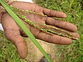
 Tendu Patta (Leaf) collection in Chhattisgarh, India.
 -
 Victim of Fluorosis in Raigarh
 -
 Tribal Youth of Bastar
 -
 Native of Chhattisgarh Plains with Neem Branches and Leaves on Hareli Festival
 -
 Adivasi woman and child
 -
 Social Mission Against Blind Faith
 -
 Adivasi Woman at Farasgaon Market
 -
 Natives of Kamar Tribe
 -
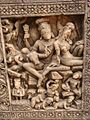 A carving in the 10th- or 11th-century Hindu temple of Malhar village. This area, 40 km from Bilaspur, was supposedly a major Buddhist center in ancient times.
 -
 Pandwani
 -
 Raut Nacha
 -
 Sua Nacha at Khudmudi Village, Chhattisgarh
 -
 Natya Samaroh by IPTA
 -
 Red Velvet Mite is used as Medicine in Traditional Healing of Chhattisgarh
 -
 Chloroxylon is used for Pest Management in Organic Rice Cultivation in Chhattisgarh, India
 -
 Medicinal Rice of Chhattisgarh used as Immune Booster
 -
 Herbal Farming in Chhattisgarh: Aloe vera
 -
 Herbal Farming in Chhattisgarh: Gulbakawali
 -
 Herbal Farming in Chhattisgarh: Safed Musli with Arhar
 -
 Kodo Millet is used as Life Saving Medicine in Chhattisgarh, India
 -
 Bastar Beer prepared from Sulfi
 -
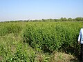
 Flora of Kabirdham District
 -
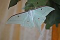 Indian Luna Moth in Chhattisgarh Forest
 -
 Ventilago in Biodiversity Rich Chhattisgarh Forest
 -
 Mahua
Mahua -
 Maikal Hills in Chhattisgarh
 -
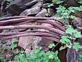
 Mineral Wealth from Chandidongri, Chhattisgarh
 -
 View of Chitrakot Falls, Jagdalpur
 -
 View of Amritdhara falls, Chirmiri
 -
 School children in Chhattisgarh


రాష్ట్రం లోని జిల్లాలు[మార్చు]
ఛత్తీస్గఢ్లో 33 జిల్లాలు ఉన్నాయి. [12] [13] [14] [15] [16] [17] [18] [19]
| వ.సంఖ్య | కోడ్ | జిల్లా | ప్రధాన కార్యాలయం | జనాభా (2011) | Area (చ.కి.మీ) | జనసాంద్రత (చ.కి.మీ.కు) | అధికార వెబ్సైట్ |
|---|---|---|---|---|---|---|---|
| 1 | బాలోద్ జిల్లా | బాలోద్ | 826,165 | 3,527.00 | 234 | http://balod.gov.in/ | |
| 2 | బలోడా బజార్ జిల్లా | బలోడా బజార్ | 1,078,911 | 3,733.87 | 290 | https://balodabazar.gov.in/ | |
| 3 | బలరాంపూర్ జిల్లా | బలరాంపూర్ | 730,491 | 6,016.34 | 100 | http://balrampur.gov.in/ | |
| 4 | BA | బస్తర్ జిల్లా | జగదల్పూర్ | 834,873 | 6,596.90 | 213 | http://bastar.gov.in/ |
| 5 | బెమెతరా జిల్లా | బెమెతరా | 795,759 | 2,854.81 | 279 | http://bemetara.gov.in/ | |
| 6 | బీజాపూర్ జిల్లా | బీజాపూర్ | 255,230 | 6,552.96 | 39 | http://bijapur.gov.in/ | |
| 7 | BI | బిలాస్పూర్ జిల్లా | బిలాస్పూర్ | 1,625,502 | 3,511.10 | 463 | http://bilaspur.gov.in/ |
| 8 | DA | దంతేవాడ జిల్లా | దంతెవాడ | 283,479 | 3,410.50 | 83 | http://dantewada.gov.in/ |
| 9 | DH | ధమ్తారి జిల్లా | ధమ్తారి | 799,781 | 4,081.93 | 196 | http://dhamtari.gov.in/ |
| 10 | DU | దుర్గ్ జిల్లా | దుర్గ్ | 1,721,948 | 2,319.99 | 742 | http://durg.gov.in/ |
| 11 | GB | గరియాబంద్ జిల్లా | గరియాబండ్ | 597,653 | 5,854.94 | 103 | http://gariaband.gov.in/ |
| 12 | GPM | గౌరెల్లా పెండ్రా మార్వాహీ జిల్లా | గౌరెల్లా | 336,420 | 2,307.39 | 166 | https://gaurela-pendra-marwahi.cg.gov.in/ |
| 13 | JC | జాంజ్గిర్ చంపా జిల్లా | జాంజ్గిర్ | 966,671 | 4,466.74 | 360 | http://janjgir-champa.gov.in/ |
| 14 | JA | జష్పూర్ జిల్లా | జష్పూర్ నగర్ | 851,669 | 6,457.41 | 132 | https://jashpur.nic.in/en/ |
| 15 | KW | కబీర్ధామ్ జిల్లా | కవర్ధా | 822,526 | 4,447.05 | 185 | http://kawardha.gov.in/ |
| 16 | KK | కాంకేర్ జిల్లా | కాంకేర్ | 748,941 | 6,432.68 | 117 | http://kanker.gov.in/ |
| 17 | కొండగావ్ జిల్లా | కొండగావ్ | 578,326 | 6,050.73 | 96 | http://kondagaon.gov.in/ | |
| 18 | KCG | ఖైరాఘఢ్ చుయిఖదాన్ గండై జిల్లా | ఖైరాగఢ్ | 368,444 | - | - | |
| 19 | KB | కోర్బా జిల్లా | కోర్బా | 1,206,640 | 7,145.44 | 169 | http://korba.gov.in/ |
| 20 | KJ | కోరియా జిల్లా | బైకుంఠ్పూర్ | 247,427 | 2378 | 37 | http://korea.gov.in/ |
| 21 | MA | మహాసముంద్ జిల్లా | మహాసముంద్ | 1,032,754 | 4,963.01 | 208 | http://mahasamund.gov.in/ |
| 22 | MCB | మనేంద్రగఢ్ చిర్మిరి భరత్పూర్ జిల్లా | మనేంద్రగఢ్ | 376000 | 4226 | - | |
| 23 | MM | మొహ్లా మన్పూర్ అంబాగఢ్ చౌకీ జిల్లా | మొహ్లా | 283,947 | - | - | |
| 24 | ముంగేలి జిల్లా | ముంగేలి | 701,707 | 2,750.36 | 255 | http://mungeli.gov.in | |
| 25 | నారాయణపూర్ జిల్లా | నారాయణపూర్ | 139,820 | 6,922.68 | 20 | http://narayanpur.gov.in/ | |
| 26 | RG | రాయగఢ్ జిల్లా | రాయగఢ్ | 1,112,982 | - | - | http://raigarh.gov.in/ |
| 27 | RP | రాయ్పూర్ జిల్లా | రాయ్పూర్ | 2,160,876 | 2,914.37 | 742 | http://raipur.gov.in/ |
| 28 | RN | రాజ్నంద్గావ్ జిల్లా | రాజ్నంద్గావ్ | 884,742 | 8,070 | 110 | http://rajnandgaon.gov.in/ |
| 29 | SB | సారన్గఢ్ బిలాయిగఢ్ జిల్లా | సారన్గఢ్ | 607,434 | - | - | |
| 30 | Skt | శక్తి జిల్లా | శక్తి | 653,036 | - | - | |
| 31 | SK | సుకుమ జిల్లా | సుక్మా | 250,159 | 5,767.02 | 43 | https://sukma.gov.in/ |
| 32 | SJ | సూరజ్పూర్ జిల్లా | సూరజ్పూర్ | 789,043 | 4,998.26 | 158 | http://surajpur.gov.in/ |
| 33 | SU | సుర్గుజా జిల్లా | అంబికాపూర్ | 840,352 | 5,019.80 | 167 | http://surguja.gov.in/ |
వీటిలో బీజాపూర్, నారాయణ్ పూర్ లను 2007 మే 2 న రాష్ట్ర ప్రభుత్వం చే పరిపాలనా సౌలభ్యానికై విభజించబడ్డాయి.
మూలాలు[మార్చు]
- ↑ "Chhattisgarh State Song : अरपा पैरी के धार... बना छत्तीसगढ़ का राजगीत". Nai Dunia. 4 November 2019. Archived from the original on 21 March 2020. Retrieved 21 March 2020.
- ↑ "Chattisgarh's official song to play after Vande Mataram to mark commencement of assembly session". ANI News. Archived from the original on 21 March 2020. Retrieved 21 March 2020.
- ↑ "Vishnu Deo Sai to be Chief Minister of Chhattisgarh: Sources". India Today (in ఇంగ్లీష్). Archived from the original on 10 December 2023. Retrieved 2023-12-10.
- ↑ "Official site of the Ministry of Statistics and Programme Implementation, India". Archived from the original on 3 December 2013. Retrieved 20 July 2013.
- ↑ "छत्तीसगढ़ के सर्वोच्च शिखर गौरलाटा पर 5 वर्ष की एडविना कांत". Nai Dunia (in హిందీ). 2015-05-17. Archived from the original on 24 March 2023. Retrieved 2023-03-24.
- ↑ "Projected Population of Indian States" (PDF). Archived (PDF) from the original on 16 January 2019.
- ↑ "The Chhattisgarh Official Language (Amendment) Act, 2007" (PDF). indiacode.nic.in. 2008. Archived (PDF) from the original on 25 December 2022. Retrieved 25 December 2022.
- ↑ 8.0 8.1 ఉల్లేఖన లోపం: చెల్లని
<ref>ట్యాగు;Chhattisgarh_Budget_Analysis_2023-24అనే పేరుగల ref లలో పాఠ్యమేమీ ఇవ్వలేదు - ↑ "Standard: ISO 3166 — Codes for the representation of names of countries and their subdivisions". Archived from the original on 17 June 2016. Retrieved 24 November 2023.
- ↑ "State of Literacy" (PDF). Census of India. p. 114. Archived from the original (PDF) on 7 May 2012.
- ↑ "Sex ratio of State and Union Territories of India as per National Health survey (2019-2021)". Ministry of Health and Family Welfare, India. Archived from the original on 8 January 2023. Retrieved 8 January 2023.
- ↑ Anita (2 January 2012). "Chhattisgarh gets New Year gift - 9 new districts!". Oneindia. Retrieved 16 February 2016.
- ↑ "Electoral rolls". Office of the Chief Electoral Officer, Chhattisgarh. Archived from the original on 2012-03-05.
- ↑ Chhattisgarh at a glance-2002 Archived 2012-04-04 at the Wayback Machine Govt. of Chhattisgarh official website.
- ↑ List of Chhattisgarh District Centres Archived 2012-02-20 at the Wayback Machine at'NIC, Chhattisgarh official Portal
- ↑ Mathew, K.M. (ed.). Manorama Yearbook 2008, Kottayam: Malayala Manorama, ISSN 0542-5778, p.518
- ↑ "Gaurela-Pendra-Marwahi to become Chhattisgarh's 28th district on February 10". The New Indian Express. Express News Service. 31 December 2019. Retrieved 26 February 2020.
- ↑ "Gaurela-Pendra-Marwahi inaugurated as C'garh's 28th district". Business Standard. Press Trust of India. 10 February 2020. Retrieved 26 February 2020.
- ↑ Ravish Pal Singh (August 15, 2021). "Chhattisgarh CM Bhupesh Baghel announces 4 new districts, 18 tehsils". India Today. Retrieved 2021-10-01.
బయటి లింకులు[మార్చు]
 ఛత్తీస్గఢ్ travel guide from Wikivoyage
- Chhattisgarh News
- Chhattisgarh's traditional Recipes/Food/Cusine
| రాష్ట్రాలు | ఆంధ్రప్రదేశ్ · అరుణాచల్ ప్రదేశ్ · అసోం · బీహార్ · ఛత్తీస్గఢ్ · గోవా · గుజరాత్ · హర్యానా · హిమాచల్ ప్రదేశ్ · జార్ఖండ్ · కర్ణాటక · కేరళ · మధ్య ప్రదేశ్ · మహారాష్ట్ర · మణిపూర్ · మేఘాలయ · మిజోరాం · నాగాలాండ్ · ఒరిస్సా · పంజాబ్ · రాజస్థాన్ · సిక్కిం · తమిళనాడు · తెలంగాణ · త్రిపుర · ఉత్తరాంచల్ · ఉత్తర ప్రదేశ్ · పశ్చిమ బెంగాల్ |
|---|---|
| కేంద్రపాలిత ప్రాంతాలు | |
- Pages with non-numeric formatnum arguments
- మూలాల లోపాలున్న పేజీలు
- CS1 హిందీ-language sources (hi)
- విస్తరించవలసిన వ్యాసాలు
- November 2017 from Use Indian English
- All Wikipedia articles written in Indian English
- క్లుప్త వివరణ ఉన్న articles
- Commons category link from Wikidata
- ఛత్తీస్గఢ్
- భారతదేశ రాష్ట్రాలు, ప్రాంతాలు