దస్త్రం:Astronaut Photograph - Pearl Harbor, Hawaii.jpg
Jump to navigation
Jump to search

ఈ మునుజూపు పరిమాణం: 800 × 531 పిక్సెళ్ళు. ఇతర రిజల్యూషన్లు: 320 × 212 పిక్సెళ్ళు | 640 × 425 పిక్సెళ్ళు | 1,024 × 679 పిక్సెళ్ళు | 1,280 × 849 పిక్సెళ్ళు | 3,072 × 2,038 పిక్సెళ్ళు.
అసలు దస్త్రం (3,072 × 2,038 పిక్సెళ్ళు, ఫైలు పరిమాణం: 1.78 MB, MIME రకం: image/jpeg)
This is a file from the Wikimedia Commons. Information from its description page there is shown below. Commons is a freely licensed media file repository. You can help. |
సారాంశం
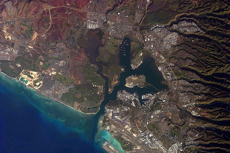
| వివరణ |
English: This detailed astronaut photograph illustrates the southern coastline of the Hawaiian island Oahu, including Pearl Harbour. The urban areas of Waipahu, Pearl City, and Aliamanu border the harbour to the north-west, north, and east. The built-up areas, recognizable by linear streets and white rooftops, contrast sharply with the reddish volcanic soils and green vegetation on the surrounding hills.
|
||||||||||||||||||||||||||||||||||||||||||||||||||
| తేదీ | |||||||||||||||||||||||||||||||||||||||||||||||||||
| మూలం | NASA Earth Observatory | ||||||||||||||||||||||||||||||||||||||||||||||||||
| కర్త | This image was taken by the NASA Expedition 21 crew | ||||||||||||||||||||||||||||||||||||||||||||||||||
| ఇతర కూర్పులు |
|
||||||||||||||||||||||||||||||||||||||||||||||||||

| Camera location | | View this and other nearby images on: OpenStreetMap |
|---|
This image or video was catalogued by Johnson Space Center of the United States National Aeronautics and Space Administration (NASA) under Photo ID: ISS021-E-15710. This tag does not indicate the copyright status of the attached work. A normal copyright tag is still required. See Commons:Licensing. Other languages:
|
Image aquired with a Nikon D2Xs digital camera fitted with a 400 mm lens, and is provided by the ISS Crew Earth Observations experiment and Image Science & Analysis Laboratory, Johnson Space Centre.
Lopa!
- kopb
లైసెన్సింగ్
| This file is in the public domain in the United States because it was solely created by NASA. NASA copyright policy states that "NASA material is not protected by copyright unless noted". (See Template:PD-USGov, NASA copyright policy page or JPL Image Use Policy.) | ||
 |
Warnings:
|
| Annotations | This image is annotated: View the annotations at Commons |
ఫైలు చరితం
తేదీ/సమయం ను నొక్కి ఆ సమయాన ఫైలు ఎలా ఉండేదో చూడవచ్చు.
| తేదీ/సమయం | నఖచిత్రం | కొలతలు | వాడుకరి | వ్యాఖ్య | |
|---|---|---|---|---|---|
| ప్రస్తుత | 09:41, 9 జూన్ 2010 | | 3,072 × 2,038 (1.78 MB) | Originalwana | higher res |
| 13:20, 7 డిసెంబరు 2009 |  | 1,440 × 960 (745 KB) | Originalwana | {{Information |Description={{en|1=This detailed astronaut photograph illustrates the southern coastline of the Hawaiian island Oahu, including Pearl Harbour. The urban areas of Waipahu, Pearl City, and Aliamanu border the harbour to the north-west, north, |
లింకులు
ఈ ఫైలును వాడుతున్న పేజీలు లేవు.
సార్వత్రిక ఫైలు వాడుక
ఈ దస్త్రాన్ని ఈ క్రింది ఇతర వికీలు ఉపయోగిస్తున్నాయి:
- hi.wikipedia.org లో వాడుక
- vi.wikipedia.org లో వాడుక