దస్త్రం:Colonisation 1800.png
Jump to navigation
Jump to search
ఈ మునుజూపు పరిమాణం: 800 × 351 పిక్సెళ్ళు. ఇతర రిజల్యూషన్లు: 320 × 140 పిక్సెళ్ళు | 640 × 281 పిక్సెళ్ళు | 1,425 × 625 పిక్సెళ్ళు.
అసలు దస్త్రం (1,425 × 625 పిక్సెళ్ళు, ఫైలు పరిమాణం: 42 KB, MIME రకం: image/png)
This is a file from the Wikimedia Commons. Information from its description page there is shown below. Commons is a freely licensed media file repository. You can help. |
సారాంశం
| వివరణ |
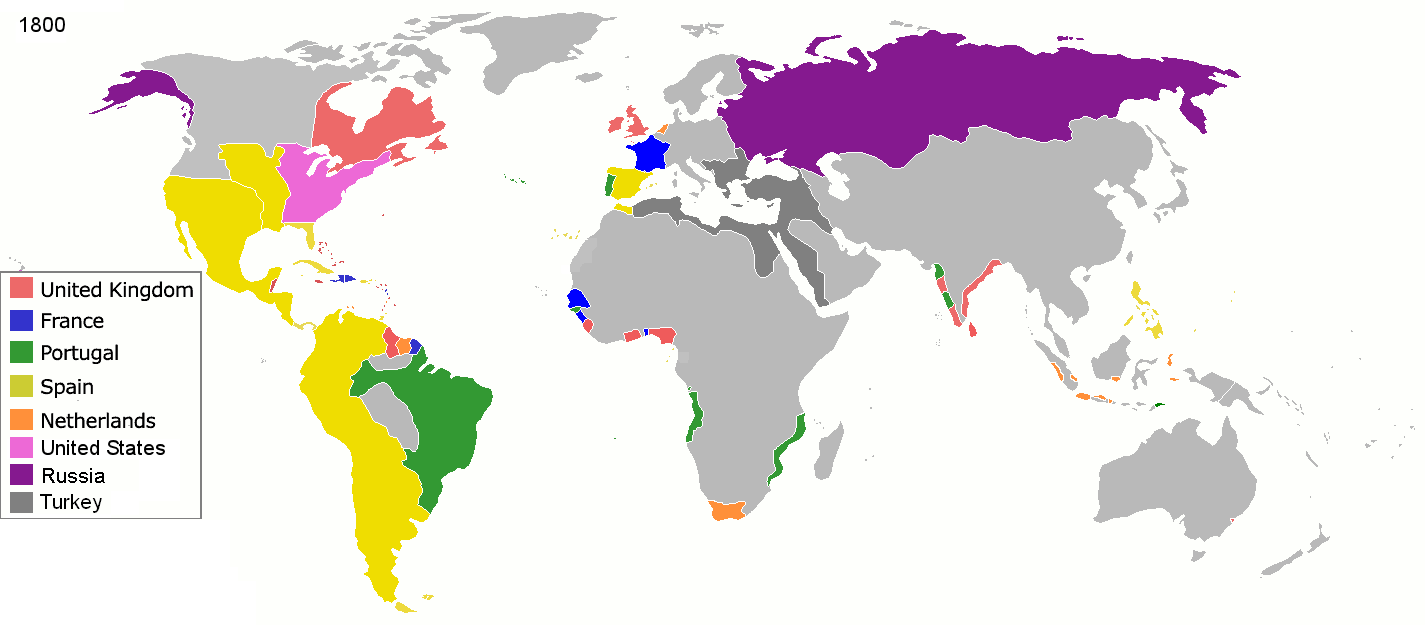
English: Colonial empires in 1800 Français : Empires coloniaux en 1800 Español: Imperios coloniales en 1800 Português: Impérios Coloniais em 1800
United Kingdom
France
Portugal
Spain
Netherlands
United States
Russia
Turkey
|
||||||||||||||||
| తేదీ | |||||||||||||||||
| మూలం | స్వంత కృతి | ||||||||||||||||
| కర్త | Jluisrs | ||||||||||||||||
| అనుమతి (ఈ దస్త్రాన్ని పునర్వినియోగించుకోవడం) |
|
||||||||||||||||
.jpg)
._LOC_2001620596.jpg)

|
File:Colonial empires in 1800.svg is a vector version of this file. It should be used in place of this PNG file when not inferior.
File:Colonisation 1800.png → File:Colonial empires in 1800.svg
For more information, see Help:SVG. |
 |
| Annotations | This image is annotated: View the annotations at Commons |
ఫైలు చరితం
తేదీ/సమయం ను నొక్కి ఆ సమయాన ఫైలు ఎలా ఉండేదో చూడవచ్చు.
| తేదీ/సమయం | నఖచిత్రం | కొలతలు | వాడుకరి | వ్యాఖ్య | |
|---|---|---|---|---|---|
| ప్రస్తుత | 19:28, 1 మే 2016 | | 1,425 × 625 (42 KB) | Mega-light | Dominican Republic was a French colonia between 1795 and 1808 through Treaty of Basilea. |
| 19:21, 1 మే 2016 |  | 1,425 × 625 (42 KB) | Mega-light | Dominican Republic was a French colonia between 1795 and 1808. | |
| 23:55, 27 సెప్టెంబరు 2014 |  | 1,425 × 625 (42 KB) | Leftcry | minor | |
| 05:48, 16 మే 2013 |  | 1,425 × 625 (40 KB) | Kraj35 | British settlement in Australia - Sydney and Parramatta. | |
| 03:30, 16 జనవరి 2012 |  | 1,425 × 625 (52 KB) | Quigley | cleaner legend | |
| 14:07, 29 ఏప్రిల్ 2010 |  | 1,425 × 625 (49 KB) | Kieran4 | Border changes | |
| 14:06, 29 ఏప్రిల్ 2010 |  | 1,425 × 625 (49 KB) | Kieran4 | Dutch claims in Indonesia were exaggerated and Cape Colony was too small. | |
| 14:06, 29 ఏప్రిల్ 2010 |  | 1,425 × 625 (49 KB) | Kieran4 | Dutch claims in Indonesia were exaggerated and Cape Colony was too small. | |
| 16:50, 15 ఫిబ్రవరి 2009 |  | 1,425 × 625 (49 KB) | EuroHistoryTeacher | lousiana was spanish in 1800, would be french officially in 1803 then sold to USA. no spanish settlement in western sahara, or spanish guinea. USA was not a colonisation power. | |
| 20:38, 21 జనవరి 2009 |  | 1,425 × 625 (49 KB) | TashkentFox | {{Information |Description= |Source= |Date= |Author= |Permission= |other_versions= }} |
లింకులు
ఈ ఫైలును వాడుతున్న పేజీలు లేవు.
సార్వత్రిక ఫైలు వాడుక
ఈ దస్త్రాన్ని ఈ క్రింది ఇతర వికీలు ఉపయోగిస్తున్నాయి:
- af.wikipedia.org లో వాడుక
- ast.wikipedia.org లో వాడుక
- av.wikipedia.org లో వాడుక
- az.wikipedia.org లో వాడుక
- ba.wikipedia.org లో వాడుక
- be.wikipedia.org లో వాడుక
- ca.wikipedia.org లో వాడుక
- ce.wikipedia.org లో వాడుక
- cs.wikipedia.org లో వాడుక
- da.wikipedia.org లో వాడుక
- en.wikipedia.org లో వాడుక
- eo.wikipedia.org లో వాడుక
- es.wikipedia.org లో వాడుక
- eu.wikipedia.org లో వాడుక
- fi.wikipedia.org లో వాడుక
- fr.wikipedia.org లో వాడుక
- gl.wikipedia.org లో వాడుక
- ha.wikipedia.org లో వాడుక
- he.wikipedia.org లో వాడుక
- hy.wikipedia.org లో వాడుక
- id.wikipedia.org లో వాడుక
- io.wikipedia.org లో వాడుక
- it.wikipedia.org లో వాడుక
- ja.wikipedia.org లో వాడుక
- ka.wikipedia.org లో వాడుక
ఈ దస్త్రపు మరింత సార్వత్రిక వాడుకను చూడండి.