దస్త్రం:Dromaius novaehollandiae map distribution 2.svg
Jump to navigation
Jump to search

ఈ ఫైలు SVG కు చెందిన ఈ మునుజూపు PNG పరిమాణం: 736 × 600 పిక్సెళ్ళు. ఇతర రిజల్యూషన్లు: 295 × 240 పిక్సెళ్ళు | 589 × 480 పిక్సెళ్ళు | 942 × 768 పిక్సెళ్ళు | 1,257 × 1,024 పిక్సెళ్ళు | 2,513 × 2,048 పిక్సెళ్ళు | 1,108 × 903 పిక్సెళ్ళు.
అసలు దస్త్రం (SVG ఫైలు, నామమాత్రంగా 1,108 × 903 పిక్సెళ్ళు, ఫైలు పరిమాణం: 114 KB)
This is a file from the Wikimedia Commons. Information from its description page there is shown below. Commons is a freely licensed media file repository. You can help. |
సారాంశం
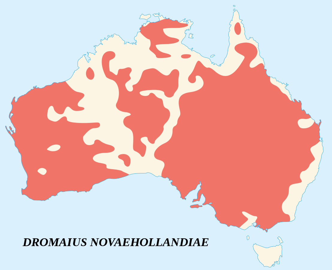
| వివరణ |
English: Emu's recorded observations map (Dromaius Novaehollandiae).
Areas where emu has been recorded. Français : Carte d'observations de l'Émeu d'Australie (Dromaius Novaehollandiae).
Zones où des émeus ont été observés. |
||
| తేదీ | |||
| మూలం |
English:
Français : |
||
| కర్త | Sémhur (talk) | ||
| ఆపాదింపు (required by the license) | © Sémhur / Wikimedia Commons / | ||
| SVG | W3C-validity not checked.
|
||
| Atelier graphique |

| Camera location | | View this and other nearby images on: OpenStreetMap |
|---|
లైసెన్సింగ్
నేను, ఈ కృతి యొక్క కాపీహక్కుదారుని, దీన్ని ఇందుమూలముగా ఈ లైసెన్సుల క్రింద ప్రచురిస్తున్నాను:
| కాపీలెఫ్ట్: ఇది స్వేచ్ఛా కృతి; దీన్ని మీరు స్వేచ్ఛా కళ లైసెన్సు నియామాలకు లోబడి పునఃపంపిణీ చేయవచ్చు మరియు/లేదా మార్చుకోవచ్చు. ఈ లైసెన్సు యొక్క ప్రతిని కాపీలెఫ్ట్ అట్టిట్యూడ్ సైటు లోనూ మరియు ఇతర సైట్లలోనూ చూడవచ్చు. |
This file is licensed under the Creative Commons Attribution-Share Alike 4.0 International, 3.0 Unported, 2.5 Generic, 2.0 Generic and 1.0 Generic license.
- ఇలా చేసేందుకు మీకు స్వేచ్ఛ ఉంది:
- పంచుకోడానికి – ఈ కృతిని కాపీ చేసుకోవచ్చు, పంపిణీ చేయవచ్చు, ప్రసారమూ చేయవచ్చు
- రీమిక్స్ చేయడానికి – కృతిని అనుకరించడానికి
- క్రింది షరతులకు లోబడి:
- ఆపాదింపు – సముచితమైన శ్రేయస్సును ఇవ్వాలి, లైసెన్సుకు లింకు ఇవ్వాలి, మార్పులేమైనా చేస్తే వాటిని సూచించాలి. అందుకు సముచితమైన పద్ధతి దేన్నైనా అవలంబించవచ్చు. కానీ మీకూ మీ వాడుకకూ హక్కుదారు అనుమతించారు అనే అర్థం వచ్చేటట్లుగా మాత్రం కాదు.
- share alike – మీరు ఈ కృతిని అనుకరిస్తే, మారిస్తే, లేదా మెరుగుపరిస్తే తత్ఫలిత కృతిని ఇదే లైసెన్సు లేదా దీనికి అనుగుణ్యమైన లైసెన్సు క్రింద మాత్రమే పంపిణీ చేయాలి.
పైవాటిలో మీకు నచ్చిన లైసెన్సునును ఎంచుకోవచ్చు.
ఫైలు చరితం
తేదీ/సమయం ను నొక్కి ఆ సమయాన ఫైలు ఎలా ఉండేదో చూడవచ్చు.
| తేదీ/సమయం | నఖచిత్రం | కొలతలు | వాడుకరి | వ్యాఖ్య | |
|---|---|---|---|---|---|
| ప్రస్తుత | 15:09, 25 జూన్ 2007 | | 1,108 × 903 (114 KB) | Sémhur | better coast lines |
| 11:29, 24 జూన్ 2007 |  | 1,108 × 903 (72 KB) | Sémhur | {{Information |Description= {{fr|Carte d'observations de l'émeu (''Dromaius Novaehollandiae'').<br/>Légende : en marron, zones où des émeus ont été observés.}} {{en|Emu's recorded observations map (''Dromaius Novaehollandiae'').<br/>Legend : maroon |
లింకులు
కింది పేజీలలో ఈ ఫైలుకు లింకులు ఉన్నాయి:
సార్వత్రిక ఫైలు వాడుక
ఈ దస్త్రాన్ని ఈ క్రింది ఇతర వికీలు ఉపయోగిస్తున్నాయి:
- an.wikipedia.org లో వాడుక
- ar.wikipedia.org లో వాడుక
- arz.wikipedia.org లో వాడుక
- ast.wikipedia.org లో వాడుక
- be.wikipedia.org లో వాడుక
- bg.wikipedia.org లో వాడుక
- bn.wikipedia.org లో వాడుక
- ca.wikipedia.org లో వాడుక
- ceb.wikipedia.org లో వాడుక
- cs.wikipedia.org లో వాడుక
- cy.wikipedia.org లో వాడుక
- de.wikipedia.org లో వాడుక
- en.wikipedia.org లో వాడుక
- eo.wikipedia.org లో వాడుక
- et.wikipedia.org లో వాడుక
- eu.wikipedia.org లో వాడుక
- fa.wikipedia.org లో వాడుక
- fi.wikipedia.org లో వాడుక
- ga.wikipedia.org లో వాడుక
- gl.wikipedia.org లో వాడుక
- gu.wikipedia.org లో వాడుక
- he.wikipedia.org లో వాడుక
- hr.wikipedia.org లో వాడుక
- hu.wikipedia.org లో వాడుక
- hy.wikipedia.org లో వాడుక
- id.wikipedia.org లో వాడుక
- incubator.wikimedia.org లో వాడుక
- is.wikipedia.org లో వాడుక
- ja.wikipedia.org లో వాడుక
- jv.wikipedia.org లో వాడుక
- ka.wikipedia.org లో వాడుక
- kk.wikipedia.org లో వాడుక
- kn.wikipedia.org లో వాడుక
- ko.wikipedia.org లో వాడుక
- kw.wikipedia.org లో వాడుక
- la.wikipedia.org లో వాడుక
- lt.wikipedia.org లో వాడుక
- lv.wikipedia.org లో వాడుక
- mk.wikipedia.org లో వాడుక
- ml.wikipedia.org లో వాడుక
- ms.wikipedia.org లో వాడుక
- my.wikipedia.org లో వాడుక
- nn.wikipedia.org లో వాడుక
- no.wikipedia.org లో వాడుక
- nv.wikipedia.org లో వాడుక
- or.wikipedia.org లో వాడుక
ఈ దస్త్రపు మరింత సార్వత్రిక వాడుకను చూడండి.