దస్త్రం:Floristic regions in Europe (english).png
Jump to navigation
Jump to search

ఈ మునుజూపు పరిమాణం: 751 × 600 పిక్సెళ్ళు. ఇతర రిజల్యూషన్లు: 301 × 240 పిక్సెళ్ళు | 601 × 480 పిక్సెళ్ళు | 962 × 768 పిక్సెళ్ళు | 1,280 × 1,022 పిక్సెళ్ళు | 1,797 × 1,435 పిక్సెళ్ళు.
అసలు దస్త్రం (1,797 × 1,435 పిక్సెళ్ళు, ఫైలు పరిమాణం: 1.95 MB, MIME రకం: image/png)
This is a file from the Wikimedia Commons. Information from its description page there is shown below. Commons is a freely licensed media file repository. You can help. |
.png)
సారాంశం
| వివరణ |
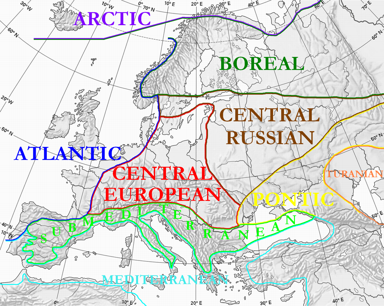
English: Floristic regions in Europe and western Siberia, according to Wolfgang Frey and Rainer Lösch
Français : Régions floristiques européennes actuelles (Europe et Siberie occidentale), selon Wolfgang Frey et Rainer Lösch |
| తేదీ | |
| మూలం | స్వంత కృతి |
| కర్త | User:Olahus |
| ఇతర కూర్పులు | Derivative works of this file: Floristic regions in Europe-de.png |

|
This biogeographical map image could be re-created using vector graphics as an SVG file. This has several advantages; see Commons:Media for cleanup for more information. If an SVG form of this image is available, please upload it and afterwards replace this template with
{{vector version available|new image name}}.
It is recommended to name the SVG file “Floristic regions in Europe (english).svg”—then the template Vector version available (or Vva) does not need the new image name parameter. |
లైసెన్సింగ్
| నేను, ఈ కృతి యొక్క కాపీహక్కుదారుని, ఈ కృతిని సార్వజనీనం'గా విడుదల చేస్తున్నాను. ఇది ప్రపంచవ్యాప్తంగా వర్తిస్తుంది. కొన్ని దేశాల్లో ఇది చట్టబద్ధంగా సాధ్యంకాకపోవచ్చు; అయితే: ఈ కృతిని ఎటువంటి షరతులు లేకుండా, అట్టి షరతులు చట్టం వల్ల తప్పనిసరి అయితే తప్ప, ఏ ఉద్దేశానికైనా ఉపయోగించుకునే హక్కును ఎవరికైనా నేను ప్రదానం చేస్తున్నాను. |
ఫైలు చరితం
తేదీ/సమయం ను నొక్కి ఆ సమయాన ఫైలు ఎలా ఉండేదో చూడవచ్చు.
| తేదీ/సమయం | నఖచిత్రం | కొలతలు | వాడుకరి | వ్యాఖ్య | |
|---|---|---|---|---|---|
| ప్రస్తుత | 00:36, 3 జూలై 2010 | | 1,797 × 1,435 (1.95 MB) | Ras67 | cropped |
| 22:15, 28 మార్చి 2008 |  | 1,800 × 1,442 (2.17 MB) | Olahus | {{Information |Description=Floristic regions in Europe and western Siberia, according to Wolfgang Frey and Rainer Lösch |Source=own work |Date=2008 |Author= Olahus |Permission= |other_versions= }} |
లింకులు
ఈ ఫైలును వాడుతున్న పేజీలు లేవు.
సార్వత్రిక ఫైలు వాడుక
ఈ దస్త్రాన్ని ఈ క్రింది ఇతర వికీలు ఉపయోగిస్తున్నాయి:
- ar.wikipedia.org లో వాడుక
- bn.wikipedia.org లో వాడుక
- br.wikipedia.org లో వాడుక
- bs.wikipedia.org లో వాడుక
- ca.wikipedia.org లో వాడుక
- cs.wikipedia.org లో వాడుక
- el.wikipedia.org లో వాడుక
- en.wikipedia.org లో వాడుక
- eo.wikipedia.org లో వాడుక
- es.wikipedia.org లో వాడుక
- fa.wikipedia.org లో వాడుక
- fi.wikipedia.org లో వాడుక
- frp.wikipedia.org లో వాడుక
- fr.wikipedia.org లో వాడుక
- gl.wikipedia.org లో వాడుక
- hi.wikipedia.org లో వాడుక
- hu.wikipedia.org లో వాడుక
- hy.wikipedia.org లో వాడుక
- it.wikipedia.org లో వాడుక
- ja.wikipedia.org లో వాడుక
- kk.wikipedia.org లో వాడుక
- ko.wikipedia.org లో వాడుక
ఈ దస్త్రపు మరింత సార్వత్రిక వాడుకను చూడండి.
.png)
.png)