దస్త్రం:Hacha grande from papagayo pano.jpg
Jump to navigation
Jump to search
ఈ మునుజూపు పరిమాణం: 800 × 181 పిక్సెళ్ళు. ఇతర రిజల్యూషన్లు: 320 × 72 పిక్సెళ్ళు | 640 × 145 పిక్సెళ్ళు | 1,024 × 231 పిక్సెళ్ళు | 4,000 × 904 పిక్సెళ్ళు.
అసలు దస్త్రం (4,000 × 904 పిక్సెళ్ళు, ఫైలు పరిమాణం: 1.79 MB, MIME రకం: image/jpeg)
This is a file from the Wikimedia Commons. Information from its description page there is shown below. Commons is a freely licensed media file repository. You can help. |
Hacha Grande detta anche Cima Segantini
|

సారాంశం
| Camera location | | View this and other nearby images on: OpenStreetMap |
|---|
| వివరణ |
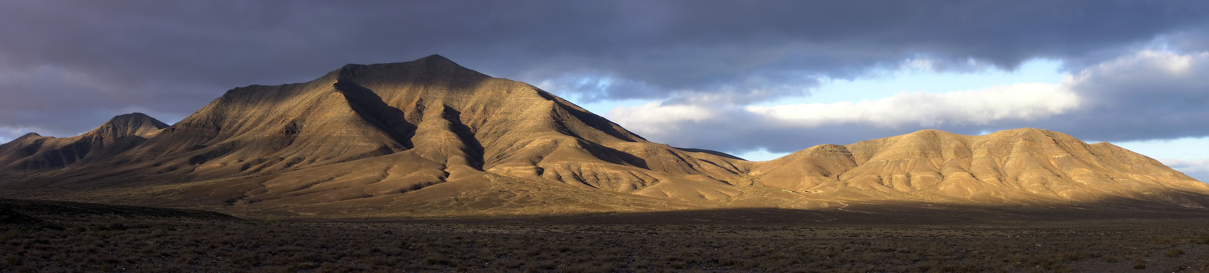
English: Hacha Grande (562m), the Degollada Valle Perdomo, Montaña Breña Estesa and the Morros de Hacha Chica (left to right) viewed across the arid plain of El Rubicón from the road to the Monumento Natural de los Ajaches (Punta de Papagayo), on the Canary Island of Lanzarote. Pico Redondo (562m) is visible on the far left. Lanzarote is a volcanic island with very low rainfall; much of the south of the island is desert and a barren expanse of lava flows. Lanzarote (Canary Islands, Spain).
Français : De gauche à droite : Pico Redondo (loin à gauche, 562m), Hacha Grande (562m), la Degollada Valle Perdomo, la Montaña Breña Estesa et les Morros de Hacha Chica, vus derrière les plaines arides d'El Rubicón depuis la route menant au Monumento Natural de los Ajaches (Punta de Papagayo), sur l'île de Lanzarote, dans les Canaries (Espagne). Lanzarote est une île volcanique et aride, le sud de l'île est un désert de laves. |
| తేదీ | |
| మూలం | స్వంత కృతి |
| కర్త | Yummifruitbat |
| అనుమతి (ఈ దస్త్రాన్ని పునర్వినియోగించుకోవడం) |
See license details |
Location from Wikipedia en:Hacha_Grande.
లైసెన్సింగ్
నేను, ఈ కృతి యొక్క కాపీహక్కుదారుని, దీన్ని ఈ లైసెన్సు క్రింద ఇందుమూలముగా ప్రచురిస్తున్నాను:
ఈ దస్త్రం క్రియేటివ్ కామన్స్ ఆపాదింపు-యథాతథ పంచుకోలు 2.5 సాధారణం లైసెన్సు క్రింద లభ్యం.
- ఇలా చేసేందుకు మీకు స్వేచ్ఛ ఉంది:
- పంచుకోడానికి – ఈ కృతిని కాపీ చేసుకోవచ్చు, పంపిణీ చేయవచ్చు, ప్రసారమూ చేయవచ్చు
- రీమిక్స్ చేయడానికి – కృతిని అనుకరించడానికి
- క్రింది షరతులకు లోబడి:
- ఆపాదింపు – సముచితమైన శ్రేయస్సును ఇవ్వాలి, లైసెన్సుకు లింకు ఇవ్వాలి, మార్పులేమైనా చేస్తే వాటిని సూచించాలి. అందుకు సముచితమైన పద్ధతి దేన్నైనా అవలంబించవచ్చు. కానీ మీకూ మీ వాడుకకూ హక్కుదారు అనుమతించారు అనే అర్థం వచ్చేటట్లుగా మాత్రం కాదు.
- share alike – మీరు ఈ కృతిని అనుకరిస్తే, మారిస్తే, లేదా మెరుగుపరిస్తే తత్ఫలిత కృతిని ఇదే లైసెన్సు లేదా దీనికి అనుగుణ్యమైన లైసెన్సు క్రింద మాత్రమే పంపిణీ చేయాలి.
| Annotations | This image is annotated: View the annotations at Commons |
ఫైలు చరితం
తేదీ/సమయం ను నొక్కి ఆ సమయాన ఫైలు ఎలా ఉండేదో చూడవచ్చు.
| తేదీ/సమయం | నఖచిత్రం | కొలతలు | వాడుకరి | వ్యాఖ్య | |
|---|---|---|---|---|---|
| ప్రస్తుత | 19:21, 31 జూలై 2006 | 4,000 × 904 (1.79 MB) | Yummifruitbat | {{Information |Description=Hacha Grande (562m), the Degollada Valle Perdomo, Montaña Breña Estesa and the Morros de Hacha Chica (left to right) viewed across the arid plain of El Rubicón from the road to the Monumento Natural de los Ajaches (Punta de |
లింకులు
కింది పేజీలలో ఈ ఫైలుకు లింకులు ఉన్నాయి:
సార్వత్రిక ఫైలు వాడుక
ఈ దస్త్రాన్ని ఈ క్రింది ఇతర వికీలు ఉపయోగిస్తున్నాయి:
- bn.wikipedia.org లో వాడుక
- ceb.wikipedia.org లో వాడుక
- de.wikipedia.org లో వాడుక
- el.wikipedia.org లో వాడుక
- en.wikipedia.org లో వాడుక
- Canary Islands
- Lanzarote
- Yaiza (municipality)
- Wikipedia:Featured pictures thumbs/04
- Wikipedia:Picture of the day/October 2006
- Wikipedia:Featured picture candidates/Hacha grande from papagayo pano.jpg
- Wikipedia:Featured picture candidates/August-2006
- Hacha Grande
- Wikipedia:Wikipedia Signpost/2006-08-14/Features and admins
- Wikipedia:Picture of the day/October 4, 2006
- Wikipedia:POTD/October 4, 2006
- Wikipedia:POTD column/October 4, 2006
- Wikipedia:POTD row/October 4, 2006
- Wikipedia:Featured pictures/Places/Panorama
- User talk:Yummifruitbat/Archive 1
- Portal:Spain/Exemplary content
- Portal:Europe/Selected panorama
- Portal:Europe/Selected panorama/6
- Wikipedia:WikiProject Volcanoes/Content
- Wikipedia:WikiProject Spain/Recognized content
- User:Godspeed1715/sandbox
- Wikipedia:Wikipedia Signpost/Single/2006-08-14
- en.wikivoyage.org లో వాడుక
- eu.wikipedia.org లో వాడుక
- fa.wikipedia.org లో వాడుక
- fi.wikipedia.org లో వాడుక
- fy.wikipedia.org లో వాడుక
- id.wikipedia.org లో వాడుక
- it.wikipedia.org లో వాడుక
- lb.wikipedia.org లో వాడుక
- lld.wikipedia.org లో వాడుక
- lt.wikipedia.org లో వాడుక
- mk.wikipedia.org లో వాడుక
- nn.wikipedia.org లో వాడుక
- pl.wikipedia.org లో వాడుక
ఈ దస్త్రపు మరింత సార్వత్రిక వాడుకను చూడండి.