దస్త్రం:Haveri region Tourism attractions map 10.11.2008.jpg
Jump to navigation
Jump to search

ఈ మునుజూపు పరిమాణం: 774 × 600 పిక్సెళ్ళు. ఇతర రిజల్యూషన్లు: 310 × 240 పిక్సెళ్ళు | 620 × 480 పిక్సెళ్ళు | 991 × 768 పిక్సెళ్ళు | 1,280 × 992 పిక్సెళ్ళు | 1,537 × 1,191 పిక్సెళ్ళు.
అసలు దస్త్రం (1,537 × 1,191 పిక్సెళ్ళు, ఫైలు పరిమాణం: 315 KB, MIME రకం: image/jpeg)
This is a file from the Wikimedia Commons. Information from its description page there is shown below. Commons is a freely licensed media file repository. You can help. |

|
This file was moved to Wikimedia Commons from en.wikipedia using a bot script. All source information is still present. It requires review. Additionally, there may be errors in any or all of the information fields; information on this file should not be considered reliable and the file should not be used until it has been reviewed and any needed corrections have been made. Once the review has been completed, this template should be removed. For details about this file, see below. Check now! |
సారాంశం
| వివరణ |
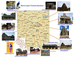
English: Haveri region Tourism attractions map
Source and Author : Manjunath Doddamani, Gajendragad / Hubli, Karnataka(India) |
| తేదీ | 10 నవంబరు 2008 (original upload date) |
| మూలం |
స్వంత కృతి Transferred from en.wikipedia |
| కర్త | Manjunath Doddamani Gajendragad at en.wikipedia |
లైసెన్సింగ్
| |
ఈ కృతిని కృతికర్త, Manjunath Doddamani Gajendragad, at the ఇంగ్లీష్ వికీపీడియా project, సార్వజనీనంగా విడుదల చేసారు. ఇది ప్రపంచవ్యాప్తంగా వర్తిస్తుంది. In case this is not legally possible: |
అసలు ఎక్కింపుల చిట్టా
The original description page was here. All following user names refer to en.wikipedia.
- 2008-11-10 16:26 Manjunath Doddamani Gajendragad 1537×1191 (322207 bytes) Haveri region Tourism attactions map Source and Author: Manjunath Doddamani, Gajendragad / Hubli, Karnataka(India)
ఫైలు చరితం
తేదీ/సమయం ను నొక్కి ఆ సమయాన ఫైలు ఎలా ఉండేదో చూడవచ్చు.
| తేదీ/సమయం | నఖచిత్రం | కొలతలు | వాడుకరి | వ్యాఖ్య | |
|---|---|---|---|---|---|
| ప్రస్తుత | 13:32, 6 నవంబరు 2011 | | 1,537 × 1,191 (315 KB) | MGA73bot2 | {{BotMoveToCommons|en.wikipedia|year={{subst:CURRENTYEAR}}|month={{subst:CURRENTMONTHNAME}}|day={{subst:CURRENTDAY}}}} == {{int:filedesc}} == {{Information |description={{en|1=Haveri region Tourism attractions map Source and Author : Manjunath Doddamani |
లింకులు
కింది పేజీలలో ఈ ఫైలుకు లింకులు ఉన్నాయి:
సార్వత్రిక ఫైలు వాడుక
ఈ దస్త్రాన్ని ఈ క్రింది ఇతర వికీలు ఉపయోగిస్తున్నాయి:
- bn.wikipedia.org లో వాడుక
- en.wikipedia.org లో వాడుక
- hi.wikipedia.org లో వాడుక
- sat.wikipedia.org లో వాడుక