దస్త్రం:Mopitt first year carbon monoxide.jpg
Jump to navigation
Jump to search

ఈ మునుజూపు పరిమాణం: 514 × 600 పిక్సెళ్ళు. ఇతర రిజల్యూషన్లు: 206 × 240 పిక్సెళ్ళు | 540 × 630 పిక్సెళ్ళు.
అసలు దస్త్రం (540 × 630 పిక్సెళ్ళు, ఫైలు పరిమాణం: 61 KB, MIME రకం: image/jpeg)
ఫైలు చరితం
తేదీ/సమయం ను నొక్కి ఆ సమయాన ఫైలు ఎలా ఉండేదో చూడవచ్చు.
| తేదీ/సమయం | నఖచిత్రం | కొలతలు | వాడుకరి | వ్యాఖ్య | |
|---|---|---|---|---|---|
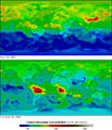
| ప్రస్తుత | 10:30, 18 మే 2005 |  | 540 × 630 (61 KB) | ChVA | From english Wikipedia The MOPITT sensor aboard NASA’s Terra satellite has assembled the first view of carbon monoxide in the Earth's atmosphere. The false colors represent levels of carbon monoxide in the lower atmosphere, ranging from about 390 part |
లింకులు
కింది పేజీలలో ఈ ఫైలుకు లింకులు ఉన్నాయి:
సార్వత్రిక ఫైలు వాడుక
ఈ దస్త్రాన్ని ఈ క్రింది ఇతర వికీలు ఉపయోగిస్తున్నాయి:
- ar.wikipedia.org లో వాడుక
- az.wikipedia.org లో వాడుక
- bn.wikipedia.org లో వాడుక
- cs.wikipedia.org లో వాడుక
- cs.wikibooks.org లో వాడుక
- el.wikipedia.org లో వాడుక
- en.wikipedia.org లో వాడుక
- fa.wikipedia.org లో వాడుక
- fr.wikipedia.org లో వాడుక
- gl.wikipedia.org లో వాడుక
- gu.wikipedia.org లో వాడుక
- ha.wikipedia.org లో వాడుక
- hy.wikipedia.org లో వాడుక
- id.wikipedia.org లో వాడుక
- ml.wikipedia.org లో వాడుక
- nds.wikipedia.org లో వాడుక
- pt.wikipedia.org లో వాడుక
- ro.wikipedia.org లో వాడుక
- ru.wikipedia.org లో వాడుక
- sh.wikipedia.org లో వాడుక
- sk.wikipedia.org లో వాడుక
- sl.wikipedia.org లో వాడుక
- sr.wikipedia.org లో వాడుక
- ta.wikipedia.org లో వాడుక
- th.wikipedia.org లో వాడుక
- vi.wikipedia.org లో వాడుక
- zh.wikipedia.org లో వాడుక

