దస్త్రం:Munnar Top station.jpg
Jump to navigation
Jump to search

ఈ మునుజూపు పరిమాణం: 800 × 494 పిక్సెళ్ళు. ఇతర రిజల్యూషన్లు: 320 × 197 పిక్సెళ్ళు | 640 × 395 పిక్సెళ్ళు | 1,024 × 632 పిక్సెళ్ళు | 1,246 × 769 పిక్సెళ్ళు.
అసలు దస్త్రం (1,246 × 769 పిక్సెళ్ళు, ఫైలు పరిమాణం: 905 KB, MIME రకం: image/jpeg)
This is a file from the Wikimedia Commons. Information from its description page there is shown below. Commons is a freely licensed media file repository. You can help. |
సారాంశం
| వివరణ |
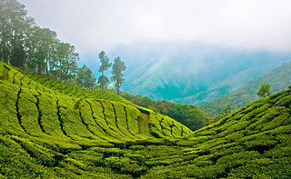
English: Top station, 41 km (1hr) from Munnar is aptly named, as it is home to some of the highest tea plantations in India. It lies on the state border between Kerala and Tamilnadu and commands a panoramic view of rolling green hills. |
||
| తేదీ | |||
| మూలం | Top Station - Munnar | ||
| కర్త | Bimal K C from Cochin, India | ||
| అనుమతి (ఈ దస్త్రాన్ని పునర్వినియోగించుకోవడం) |
ఈ దస్త్రం క్రియేటివ్ కామన్స్ ఆపాదింపు 2.0 సాధారణ లైసెన్సు క్రింద లభ్యం.
|
|
ఫైలు చరితం
తేదీ/సమయం ను నొక్కి ఆ సమయాన ఫైలు ఎలా ఉండేదో చూడవచ్చు.
| తేదీ/సమయం | నఖచిత్రం | కొలతలు | వాడుకరి | వ్యాఖ్య | |
|---|---|---|---|---|---|
| ప్రస్తుత | 13:05, 6 ఏప్రిల్ 2011 | | 1,246 × 769 (905 KB) | Ras67 | cropped |
| 12:03, 12 ఆగస్టు 2008 |  | 1,280 × 803 (952 KB) | Challiyan | {{Information |Description= Top station, 41 km (1hr) from Munnar is aptly named, as it is home to some of the highest tea plantations in India. It lies on the state border between Kerala and Tamilnadu and commands a panoramic view of rolling green hills. |
లింకులు
కింది పేజీలలో ఈ ఫైలుకు లింకులు ఉన్నాయి:
సార్వత్రిక ఫైలు వాడుక
ఈ దస్త్రాన్ని ఈ క్రింది ఇతర వికీలు ఉపయోగిస్తున్నాయి:
- bo.wikipedia.org లో వాడుక
- cs.wikipedia.org లో వాడుక
- de.wikipedia.org లో వాడుక
- en.wikipedia.org లో వాడుక
- en.wikivoyage.org లో వాడుక
- es.wikipedia.org లో వాడుక
- fr.wikipedia.org లో వాడుక
- gu.wikipedia.org లో వాడుక
- id.wikipedia.org లో వాడుక
- incubator.wikimedia.org లో వాడుక
- kn.wikipedia.org లో వాడుక
- ml.wikipedia.org లో వాడుక
- കേരളം
- മൂന്നാർ
- വിക്കിപീഡിയ:തിരഞ്ഞെടുക്കാവുന്ന ചിത്രങ്ങൾ/നിലവറ 19
- വിക്കിപീഡിയ:തിരഞ്ഞെടുത്ത ചിത്രങ്ങൾ/മേയ് 2016
- വിക്കിപീഡിയ:തിരഞ്ഞെടുത്ത ചിത്രങ്ങൾ/08-05-2016
- വിക്കിപീഡിയ:തിരഞ്ഞെടുത്ത ചിത്രങ്ങൾ/09-05-2016
- വിക്കിപീഡിയ:തിരഞ്ഞെടുത്ത ചിത്രങ്ങൾ/10-05-2016
- വിക്കിപീഡിയ:തിരഞ്ഞെടുത്ത ചിത്രങ്ങൾ/11-05-2016
- വിക്കിപീഡിയ:തിരഞ്ഞെടുത്ത ചിത്രങ്ങൾ/12-05-2016
- വിക്കിപീഡിയ:തിരഞ്ഞെടുത്ത ചിത്രങ്ങൾ/13-05-2016
- വിക്കിപീഡിയ:തിരഞ്ഞെടുത്ത ചിത്രങ്ങൾ/14-05-2016
- nl.wikipedia.org లో వాడుక
- no.wiktionary.org లో వాడుక
- pl.wikipedia.org లో వాడుక
- ru.wikipedia.org లో వాడుక
- sa.wikipedia.org లో వాడుక
- sv.wikipedia.org లో వాడుక
- ta.wikipedia.org లో వాడుక
- ur.wikipedia.org లో వాడుక
- war.wikipedia.org లో వాడుక