దస్త్రం:Punjabdoabs1.jpg
Jump to navigation
Jump to search

ఈ మునుజూపు పరిమాణం: 800 × 574 పిక్సెళ్ళు. ఇతర రిజల్యూషన్లు: 320 × 229 పిక్సెళ్ళు | 640 × 459 పిక్సెళ్ళు | 1,024 × 734 పిక్సెళ్ళు | 1,280 × 918 పిక్సెళ్ళు | 1,583 × 1,135 పిక్సెళ్ళు.
అసలు దస్త్రం (1,583 × 1,135 పిక్సెళ్ళు, ఫైలు పరిమాణం: 268 KB, MIME రకం: image/jpeg)
This is a file from the Wikimedia Commons. Information from its description page there is shown below. Commons is a freely licensed media file repository. You can help. |


సారాంశం

|
This locator map image could be re-created using vector graphics as an SVG file. This has several advantages; see Commons:Media for cleanup for more information. If an SVG form of this image is available, please upload it and afterwards replace this template with
{{vector version available|new image name}}.
It is recommended to name the SVG file “Punjabdoabs1.svg”—then the template Vector version available (or Vva) does not need the new image name parameter. |

|
This file has been superseded by PunjabDoabs.png. It is recommended to use the other file. Please note that deleting superseded images requires consent.
|

|
| వివరణ |
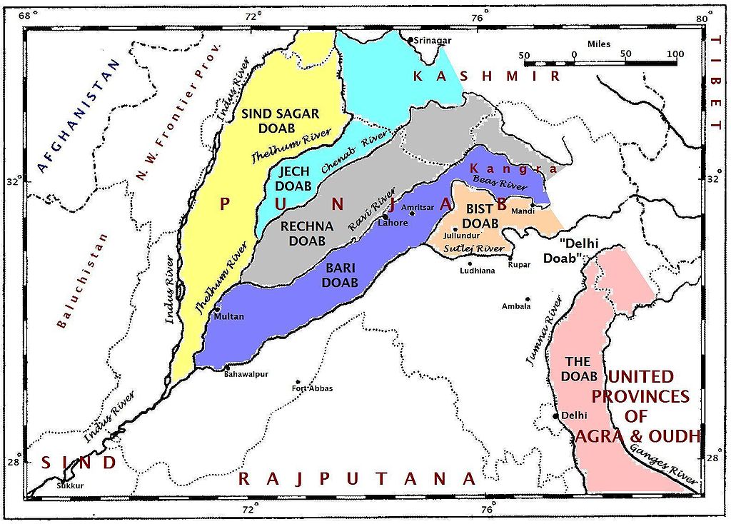
English: This map of the doabs is based on the map in the paper, "Partition of the Punjab and of Bengal," by O. H. G. Spate, The Geographical Journal, 110(4-6):201-218, November 1947. The journal was published in the United Kingdom. |
| తేదీ | |
| మూలం | స్వంత కృతి |
| కర్త | Fowler&fowler |
లైసెన్సింగ్
నేను, ఈ కృతి యొక్క కాపీహక్కుదారుని, దీన్ని ఇందుమూలముగా ఈ లైసెన్సుల క్రింద ప్రచురిస్తున్నాను:
ఈ దస్త్రం క్రియేటివ్ కామన్స్ Attribution-Share Alike 3.0 Unported లైసెన్సు క్రింద లభ్యం.
- ఇలా చేసేందుకు మీకు స్వేచ్ఛ ఉంది:
- పంచుకోడానికి – ఈ కృతిని కాపీ చేసుకోవచ్చు, పంపిణీ చేయవచ్చు, ప్రసారమూ చేయవచ్చు
- రీమిక్స్ చేయడానికి – కృతిని అనుకరించడానికి
- క్రింది షరతులకు లోబడి:
- ఆపాదింపు – సముచితమైన శ్రేయస్సును ఇవ్వాలి, లైసెన్సుకు లింకు ఇవ్వాలి, మార్పులేమైనా చేస్తే వాటిని సూచించాలి. అందుకు సముచితమైన పద్ధతి దేన్నైనా అవలంబించవచ్చు. కానీ మీకూ మీ వాడుకకూ హక్కుదారు అనుమతించారు అనే అర్థం వచ్చేటట్లుగా మాత్రం కాదు.
- share alike – మీరు ఈ కృతిని అనుకరిస్తే, మారిస్తే, లేదా మెరుగుపరిస్తే తత్ఫలిత కృతిని ఇదే లైసెన్సు లేదా దీనికి అనుగుణ్యమైన లైసెన్సు క్రింద మాత్రమే పంపిణీ చేయాలి.

|
ఈ కృతి యొక్క కర్తనైన నేను, ఇక నుండీ ఈ కృతిని కాపీ చేసుకోవడానికి, పంచి పెట్టడానికి మరియు/లేదా మార్పులు-చేర్పులు చేసుకోవడానికి GFDL, లైసెన్సు వెర్షను 1.2 లేదా దాని తరువాత స్వేచ్చా సాఫ్టువేరు ఫౌండేషను విడుదలచేసే ఏ GFDL లైసెన్సు ద్వారా నయినా అనుమతి ఇస్తున్నాను; ఈ కృతిలో మార్చకూడని బాగాలు లేవు, Front-Cover పాఠం లేదు, Back-Cover పాఠం లేదు. ఈ లైసెన్సు యొక్క పత్రం నకలును "జిఎన్యూ ఉచిత డాక్యుమెంటేషను లైసెన్సు" అని పిలుస్తున్న విభాగంలో ఉంది. |
పైవాటిలో మీకు నచ్చిన లైసెన్సునును ఎంచుకోవచ్చు.
ఫైలు చరితం
తేదీ/సమయం ను నొక్కి ఆ సమయాన ఫైలు ఎలా ఉండేదో చూడవచ్చు.
| తేదీ/సమయం | నఖచిత్రం | కొలతలు | వాడుకరి | వ్యాఖ్య | |
|---|---|---|---|---|---|
| ప్రస్తుత | 23:18, 4 ఫిబ్రవరి 2009 | | 1,583 × 1,135 (268 KB) | Fowler&fowler | {{Information |Description={{en|1=This map of the ''doabs'' is based on the map in the paper, "Partition of the Punjab and of Bengal," by O. H. G. Spate, The Geographical Journal, 110(4-6):201-218, November 1947. The journal was published in the Unit |
లింకులు
కింది పేజీలలో ఈ ఫైలుకు లింకులు ఉన్నాయి:
సార్వత్రిక ఫైలు వాడుక
ఈ దస్త్రాన్ని ఈ క్రింది ఇతర వికీలు ఉపయోగిస్తున్నాయి:
- ar.wikipedia.org లో వాడుక
- ast.wikipedia.org లో వాడుక
- azb.wikipedia.org లో వాడుక
- bg.wikipedia.org లో వాడుక
- bn.wikipedia.org లో వాడుక
- ca.wikipedia.org లో వాడుక
- de.wikipedia.org లో వాడుక
- el.wikipedia.org లో వాడుక
- en.wikipedia.org లో వాడుక
- es.wikipedia.org లో వాడుక
- fa.wikipedia.org లో వాడుక
- fr.wikipedia.org లో వాడుక
- gu.wikipedia.org లో వాడుక
- hi.wikipedia.org లో వాడుక
- it.wikipedia.org లో వాడుక
- ka.wikipedia.org లో వాడుక
- kk.wikipedia.org లో వాడుక
- ml.wikipedia.org లో వాడుక
- nl.wikipedia.org లో వాడుక
- or.wikipedia.org లో వాడుక
- pa.wikipedia.org లో వాడుక
ఈ దస్త్రపు మరింత సార్వత్రిక వాడుకను చూడండి.