దస్త్రం:TahitiMooreaMap.png
Jump to navigation
Jump to search

ఈ మునుజూపు పరిమాణం: 800 × 598 పిక్సెళ్ళు. ఇతర రిజల్యూషన్లు: 320 × 239 పిక్సెళ్ళు | 640 × 479 పిక్సెళ్ళు | 979 × 732 పిక్సెళ్ళు.
అసలు దస్త్రం (979 × 732 పిక్సెళ్ళు, ఫైలు పరిమాణం: 16 KB, MIME రకం: image/png)
This is a file from the Wikimedia Commons. Information from its description page there is shown below. Commons is a freely licensed media file repository. You can help. |
సారాంశం
| వివరణ |
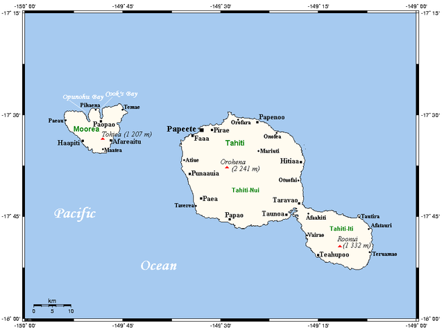
English: A map of Tahiti and Moorea in the Society Islands (French Polynesia) showing main centres and peaks |
| తేదీ | not specified |
| మూలం | This map's source is here (select Papeete in the search box), with the uploader's modifications, and the GMT homepage says that the tools are released under the GNU General Public License |
| కర్త | Kelisi at en.wikipedia |

|
This map image could be re-created using vector graphics as an SVG file. This has several advantages; see Commons:Media for cleanup for more information. If an SVG form of this image is available, please upload it and afterwards replace this template with
{{vector version available|new image name}}.
It is recommended to name the SVG file “TahitiMooreaMap.svg”—then the template Vector version available (or Vva) does not need the new image name parameter. |
లైసెన్సింగ్
Kelisi from en.wikipedia.org, ఈ కృతి యొక్క కాపీహక్కుదారు, దీన్ని ఇందుమూలముగా ఈ లైసెన్సు క్రింద ప్రచురిస్తున్నారు:
| ఈ దస్త్రం క్రియేటివ్ కామన్స్ Attribution-Share Alike 3.0 Unported లైసెన్సు క్రింద లభ్యం. Subject to disclaimers. | ||
| ఆపాదింపు: Kelisi from en.wikipedia.org | ||
| ||
| GFDL లైసెన్సు తాజాకరణలో భాగంగా ఈ దస్త్రానికి ఈ లైసెన్సింగు ట్యాగుని చేర్చారు. |

|
ఈ కృతి యొక్క కర్తనైన నేను, ఇక నుండీ ఈ కృతిని కాపీ చేసుకోవడానికి, పంచి పెట్టడానికి మరియు/లేదా మార్పులు-చేర్పులు చేసుకోవడానికి GFDL, లైసెన్సు వెర్షను 1.2 లేదా దాని తరువాత స్వేచ్చా సాఫ్టువేరు ఫౌండేషను విడుదలచేసే ఏ GFDL లైసెన్సు ద్వారా నయినా అనుమతి ఇస్తున్నాను; ఈ కృతిలో మార్చకూడని బాగాలు లేవు, Front-Cover పాఠం లేదు, Back-Cover పాఠం లేదు. ఈ లైసెన్సు యొక్క పత్రం నకలును "జిఎన్యూ ఉచిత డాక్యుమెంటేషను లైసెన్సు" అని పిలుస్తున్న విభాగంలో ఉంది. Subject to disclaimers. |
అసలు ఎక్కింపుల చిట్టా
All following user names refer to en.wikipedia.
- 2006-04-22 16:30 Kelisi 972×732×8 (16 KB) (Map of Tahiti and Moorea showing main centres, peaks. This map's source is [http://www.aquarius.geomar.de/omc/make_map.html here], with the uploader's modifications, and the [http://gmt.soest.hawaii.edu/ GMT homepage] says that the tools are released unde)
ఫైలు చరితం
తేదీ/సమయం ను నొక్కి ఆ సమయాన ఫైలు ఎలా ఉండేదో చూడవచ్చు.
| తేదీ/సమయం | నఖచిత్రం | కొలతలు | వాడుకరి | వ్యాఖ్య | |
|---|---|---|---|---|---|
| ప్రస్తుత | 08:47, 11 ఫిబ్రవరి 2009 | | 979 × 732 (16 KB) | Telim tor | == Information == {{Information |Description={{en|A map of Tahiti and Moorea in the Society Islands, French Polynesia}} |Source=This map's source is [http://www.aquarius.ifm-geomar.de/ here], with the uploader's modifications, and the [http://gmt.soest.ha |
లింకులు
ఈ ఫైలును వాడుతున్న పేజీలు లేవు.
సార్వత్రిక ఫైలు వాడుక
ఈ దస్త్రాన్ని ఈ క్రింది ఇతర వికీలు ఉపయోగిస్తున్నాయి:
- af.wikipedia.org లో వాడుక
- en.wikipedia.org లో వాడుక
- es.wikipedia.org లో వాడుక
- fa.wikipedia.org లో వాడుక
- fi.wikipedia.org లో వాడుక
- fr.wikipedia.org లో వాడుక
- gl.wikipedia.org లో వాడుక
- hu.wikipedia.org లో వాడుక
- id.wikipedia.org లో వాడుక
- it.wikipedia.org లో వాడుక
- ja.wikipedia.org లో వాడుక
- ka.wikipedia.org లో వాడుక
- kn.wikipedia.org లో వాడుక
- lt.wikipedia.org లో వాడుక
- mk.wikipedia.org లో వాడుక
- nl.wikipedia.org లో వాడుక
- no.wikipedia.org లో వాడుక
- pl.wikivoyage.org లో వాడుక
- pt.wikipedia.org లో వాడుక
- ro.wikipedia.org లో వాడుక
- ru.wikipedia.org లో వాడుక
- ty.wikipedia.org లో వాడుక
- uk.wikipedia.org లో వాడుక
- xmf.wikipedia.org లో వాడుక
- zh-yue.wikipedia.org లో వాడుక
- zh.wikipedia.org లో వాడుక