దస్త్రం:Volcano Map.png
Jump to navigation
Jump to search
మరింత స్పష్టమైన బొమ్మ లేదు.
Volcano_Map.png (611 × 273 పిక్సెళ్ళు, ఫైలు పరిమాణం: 22 KB, MIME రకం: image/png)
This is a file from the Wikimedia Commons. Information from its description page there is shown below. Commons is a freely licensed media file repository. You can help. |
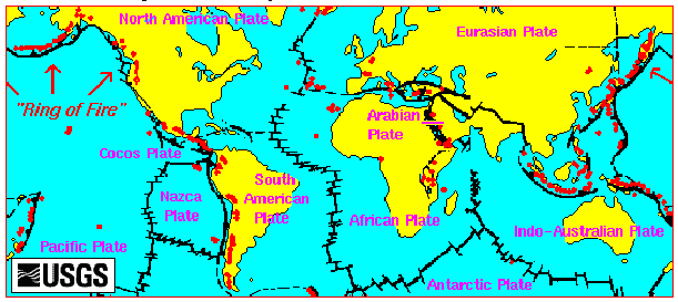
సారాంశం
English: Volcano Map from the USGS site.
లైసెన్సింగ్
This image is in the public domain in the United States because it only contains materials that originally came from the United States Geological Survey, an agency of the United States Department of the Interior. For more information, see the official USGS copyright policy.
|
ఫైలు చరితం
తేదీ/సమయం ను నొక్కి ఆ సమయాన ఫైలు ఎలా ఉండేదో చూడవచ్చు.
| తేదీ/సమయం | నఖచిత్రం | కొలతలు | వాడుకరి | వ్యాఖ్య | |
|---|---|---|---|---|---|
| ప్రస్తుత | 17:14, 29 సెప్టెంబరు 2008 | | 611 × 273 (22 KB) | Rvd4life | Volcano Map {{PD-USGov-Interior-USGS}} <!--{{ImageUpload|basic}}--> |
లింకులు
ఈ ఫైలును వాడుతున్న పేజీలు లేవు.
సార్వత్రిక ఫైలు వాడుక
ఈ దస్త్రాన్ని ఈ క్రింది ఇతర వికీలు ఉపయోగిస్తున్నాయి:
- bn.wikipedia.org లో వాడుక
- bs.wikipedia.org లో వాడుక
- cs.wikipedia.org లో వాడుక
- de.wikipedia.org లో వాడుక
- en.wikipedia.org లో వాడుక
- et.wikipedia.org లో వాడుక
- ga.wikipedia.org లో వాడుక
- gu.wikipedia.org లో వాడుక
- ha.wikipedia.org లో వాడుక
- he.wikipedia.org లో వాడుక
- hr.wikipedia.org లో వాడుక
- pnb.wikipedia.org లో వాడుక
- ru.wikipedia.org లో వాడుక
- sh.wikipedia.org లో వాడుక
- simple.wikipedia.org లో వాడుక
- ta.wikipedia.org లో వాడుక
- th.wikipedia.org లో వాడుక
- uk.wikipedia.org లో వాడుక
- ur.wikipedia.org లో వాడుక