దస్త్రం:NATO partnerships.svg
Jump to navigation
Jump to search

ఈ ఫైలు SVG కు చెందిన ఈ మునుజూపు PNG పరిమాణం: 800 × 360 పిక్సెళ్ళు. ఇతర రిజల్యూషన్లు: 320 × 144 పిక్సెళ్ళు | 640 × 288 పిక్సెళ్ళు | 1,024 × 461 పిక్సెళ్ళు | 1,280 × 576 పిక్సెళ్ళు | 2,560 × 1,152 పిక్సెళ్ళు.
అసలు దస్త్రం (SVG ఫైలు, నామమాత్రంగా 800 × 360 పిక్సెళ్ళు, ఫైలు పరిమాణం: 1.6 MB)
This is a file from the Wikimedia Commons. Information from its description page there is shown below. Commons is a freely licensed media file repository. You can help. |
సారాంశం
| వివరణ |
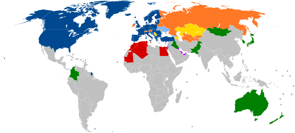
English: A global map of NATO partners around the world (with all the sovereign states that are under 20,000 km2 in area represented by a circle)
NATO member states #3131FC #2A7FFF thin solid transparent #88B7FF thin solid transparent #FFD900 thin solid transparent #FF7826 thin solid transparent #D40000 thin solid transparent #C0F thin solid transparent #008000 thin solid transparent [[:w:NATO Français : Carte montrant les affiliations actuelles des pays européens avec l'OTAN. Les pays de moins de 20000 km2 sont représentés par un cercle.
Membres actuels #3131FC #3584fd #88b7ff #FFD900 thin solid transparent #FF7826 thin solid transparent #D40000 thin solid transparent #C0F thin solid transparent #008000 thin solid transparent Partenariat
Português: Mapa mostrando as afiliações atuais dos países europeus com a OTAN. Os países com menos de 20.000 km2 são representados por um círculo.
Estados-membros da NATO #3131FC #2a7fff #88b7ff #ffd900 #ff7826 #d40000 #cc00ff #008000 Parceiros |
| తేదీ | |
| మూలం |
This file was derived from: NATO cooperations partners.svg: |
| కర్త | Patrick |
| ఇతర కూర్పులు |
Derivative works of this file: Peak positions of Adele's 21 in worldwide charts.svg Derivative works of this file: NATO partnerships - 2.svg |
| SVG పెరుగుదల |
Notes
- ↑ Partnership Interoperability Initiative. NATO (22 February 2022). Retrieved on 23 March 2022.
లైసెన్సింగ్
నేను, ఈ కృతి యొక్క కాపీహక్కుదారుని, దీన్ని ఈ లైసెన్సు క్రింద ఇందుమూలముగా ప్రచురిస్తున్నాను:
ఈ దస్త్రం క్రియేటివ్ కామన్స్ Attribution-Share Alike 3.0 Unported లైసెన్సు క్రింద లభ్యం.
- ఇలా చేసేందుకు మీకు స్వేచ్ఛ ఉంది:
- పంచుకోడానికి – ఈ కృతిని కాపీ చేసుకోవచ్చు, పంపిణీ చేయవచ్చు, ప్రసారమూ చేయవచ్చు
- రీమిక్స్ చేయడానికి – కృతిని అనుకరించడానికి
- క్రింది షరతులకు లోబడి:
- ఆపాదింపు – సముచితమైన శ్రేయస్సును ఇవ్వాలి, లైసెన్సుకు లింకు ఇవ్వాలి, మార్పులేమైనా చేస్తే వాటిని సూచించాలి. అందుకు సముచితమైన పద్ధతి దేన్నైనా అవలంబించవచ్చు. కానీ మీకూ మీ వాడుకకూ హక్కుదారు అనుమతించారు అనే అర్థం వచ్చేటట్లుగా మాత్రం కాదు.
- share alike – మీరు ఈ కృతిని అనుకరిస్తే, మారిస్తే, లేదా మెరుగుపరిస్తే తత్ఫలిత కృతిని ఇదే లైసెన్సు లేదా దీనికి అనుగుణ్యమైన లైసెన్సు క్రింద మాత్రమే పంపిణీ చేయాలి.
అసలు ఎక్కింపుల చిట్టా
This image is a derivative work of the following images:
- NATO cooperations partners.svg licensed with Cc-by-sa-3.0
- 2012-02-06T21:37:21Z Patrickneil 800x360 (1681649 Bytes) Kosovo in gray
- 2012-02-06T21:34:07Z Patrickneil 800x360 (1681641 Bytes) Forgot Finland and Sweden
- 2012-02-06T21:26:54Z Patrickneil 800x360 (1692374 Bytes) Darker gray for non-affiliated countries
- 2012-02-06T21:23:31Z Patrickneil 800x360 (1682546 Bytes) trimming some of Micronesia for standard width of 800px
- 2012-02-06T21:11:00Z Patrickneil 842x358 (1688505 Bytes) == {{int:filedesc}} == {{Information |Description={{en|1=A global map of the world, with all the [[:en:List of countries and outlying territories by total area|sovereign states that are under 20,000 km2 in area]] represented
Uploaded with derivativeFX
ఫైలు చరితం
తేదీ/సమయం ను నొక్కి ఆ సమయాన ఫైలు ఎలా ఉండేదో చూడవచ్చు.
| తేదీ/సమయం | నఖచిత్రం | కొలతలు | వాడుకరి | వ్యాఖ్య | |
|---|---|---|---|---|---|
| ప్రస్తుత | 15:45, 7 మార్చి 2024 | | 800 × 360 (1.6 MB) | Janitoalevic | Sweden added |
| 21:59, 3 ఏప్రిల్ 2023 |  | 800 × 360 (1.6 MB) | Louloumra59 | FIN | |
| 16:00, 3 ఏప్రిల్ 2023 |  | 800 × 360 (1.6 MB) | CD967119 | They will join Tuesday, not today. | |
| 15:13, 3 ఏప్రిల్ 2023 |  | 800 × 360 (1.6 MB) | Edroeh | FIN | |
| 14:02, 31 మార్చి 2023 |  | 800 × 360 (1.6 MB) | Invinciblewalnut | Reverted to version as of 07:57, 10 August 2022 (UTC) | |
| 13:39, 31 మార్చి 2023 |  | 800 × 360 (1.55 MB) | Invinciblewalnut | changed color of sweden and finland to reflect ongoing accession process | |
| 07:57, 10 ఆగస్టు 2022 |  | 800 × 360 (1.6 MB) | Zarwada | == {{int:filedesc}} == {{Information |Description={{en|1=A global map of NATO partners around the world, with all the {{W|List of countries and outlying territories by total area|sovereign states that are under 20,000 km<sup>2</sup> in area}} represented by a circle. {{legtab|#004990 thin solid transparent|NATO {{W|Member states of NATO|member}} states |#2A7FFF thin solid transparent|{{W|Membership Action Plan}} |#88B7FF thin solid transparent|Enhanced Opportunities Partner<ref>{{cite web |... | |
| 19:43, 24 జూలై 2022 |  | 800 × 360 (1.6 MB) | Kwamikagami | rs. recent fixes, rm. non-countries | |
| 19:21, 24 జూలై 2022 |  | 800 × 360 (1.6 MB) | Kwamikagami | restore Kosovo - Reverted to version as of 16:21, 27 March 2020 (UTC) | |
| 09:29, 22 జూలై 2022 |  | 2,754 × 1,398 (1.09 MB) | Kwamikagami | NATO blue, #004990 |
లింకులు
కింది పేజీలలో ఈ ఫైలుకు లింకులు ఉన్నాయి:
సార్వత్రిక ఫైలు వాడుక
ఈ దస్త్రాన్ని ఈ క్రింది ఇతర వికీలు ఉపయోగిస్తున్నాయి:
- af.wikipedia.org లో వాడుక
- ar.wikipedia.org లో వాడుక
- حلف شمال الأطلسي
- حوار متوسطي
- الشراكة من أجل السلام
- علاقات حلف الناتو الخارجية
- قالب:علاقات حلف الناتو
- جمعية حلف الأطلسي
- مجلس الشراكة الأوروبية الأطلسية
- مبادرة اسطنبول للتعاون
- العلاقات بين روسيا وحلف شمال الأطلسي
- علاقات ألبانيا والناتو
- العلاقات بين أوكرانيا وحلف الناتو
- العلاقات بين جورجيا والناتو
- انضمام البوسنة والهرسك إلى الناتو
- العلاقات بين السويد وحلف الناتو
- العلاقات بين النمسا وحلف الناتو
- ast.wikipedia.org లో వాడుక
- az.wikipedia.org లో వాడుక
- be-tarask.wikipedia.org లో వాడుక
- bg.wikipedia.org లో వాడుక
- ca.wikipedia.org లో వాడుక
- cs.wikipedia.org లో వాడుక
- da.wikipedia.org లో వాడుక
- de.wikipedia.org లో వాడుక
- el.wikipedia.org లో వాడుక
- en.wikipedia.org లో వాడుక
- NATO
- Euro-Atlantic Partnership Council
- Partnership for Peace
- Atlantic Treaty Association
- Mediterranean Dialogue
- Individual Partnership Action Plan
- Istanbul Cooperation Initiative
- Georgia–NATO relations
- Romania in NATO
- Canada in NATO
- Ukraine–NATO relations
- Russia–NATO relations
- Talk:NATO
- Croatia–NATO relations
- Albania–NATO relations
- Montenegro–NATO relations
- North Macedonia–NATO relations
- Template:NATO relations
- Talk:NATO/Archive 3
- Moldova–NATO relations
- Bosnia and Herzegovina–NATO relations
- NATO logistics in the Afghan War
- User:Patrickneil/NATO
- Foreign relations of NATO
- Pakistan–NATO relations
ఈ దస్త్రపు మరింత సార్వత్రిక వాడుకను చూడండి.