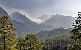
అంజావ్ జిల్లా
Anjaw district | |||||
|---|---|---|---|---|---|
Lohit river and Kibithu | |||||
 Location in Arunachal Pradesh | |||||
| Country | |||||
| State | Arunachal Pradesh | ||||
| Headquarters | Hawai | ||||
| Government | |||||
| • Lok Sabha constituencies | Arunachal East | ||||
| • Vidhan Sabha constituencies | Hayuliang | ||||
| Area | |||||
| • Total | 6,190 km2 (2,390 sq mi) | ||||
| Population (2011) | |||||
| • Total | 21,167 | ||||
| • Density | 3.4/km2 (8.9/sq mi) | ||||
| Demographics | |||||
| • Literacy | 59.4% | ||||
| • Sex ratio | 805 | ||||
| Time zone | UTC+05:30 (IST) | ||||
అంజావ్ జిల్లా, భారతదేశం, అరుణాచల్ ప్రదేశ్ రాష్ట్రానికి చెందిన జిల్లాలలో ఇది ఒకటి.[1] లోహిత్ జిల్లా లోని కొంత భూభాగం 2004 ఫిబ్రవరి 16న వేరుచేసి అంజావ్ జిల్లా రూపొందించబడింది.[2] జిల్లా ఉత్తర సరిహద్దులో చైనా ఉంది. హవాయ్ సముద్రమట్టానికి 1296 మీ ఎత్తున ఉంది. ఇది జిల్లాకు కేంద్రంగా ఉంది. ఇది బ్రహ్మపుత్ర నది ఉపనది అయిన లోహిత్ నదీతీరంలో ఉంది. ఇది తూర్పు భారతదేశ చివరిభాగంలో ఉంది.[3] అంజావ్ జిల్లా తూర్పు సరిహద్దులో డాంగ్ (అరుణాచల్ ప్రదేశ్) .[4] భారతదేశంలోని అత్యల్ప జనసాంధ్రత కలిగిన జిల్లాలలో ఇది రెండవది.[5]
చరిత్ర[మార్చు]

1962 యుద్ధం సమయంలో, అంజావ్ లోని కొన్ని ప్రాంతాలను చైనా కొంతకాలం ఆక్రమించింది.[6] వివాదాస్పద సరిహద్దు ప్రాంతం కావడంతో అంజావ్ జిల్లాలో భారత సైన్యం ఎప్పుడూ ఉంటుంది. 2020 చైనా-భారత్ వాగ్వివాదాల సమయంలో ఈ ప్రాంతానికి అదనపు దళాలను మోహరించారు.[7]
జనాభా గణాంకాలు (2011)[మార్చు]
2011 జనాభా లెక్కల ప్రకారం అరుణాచల్ ప్రదేశ్లోని అంజావ్ జిల్లాలో మొత్తం జనాభా 21,167. వీరిలో 11,507 మంది పురుషులు కాగా, 9,660 మంది మహిళలు ఉన్నారు. జిల్లాలో మొత్తం 4,612 కుటుంబాలు ఉన్నాయి. అంజావ్ జిల్లా సగటు లింగ నిష్పత్తి 839. మొత్తం జనాభాలో 4.6% మంది పట్టణ ప్రాంతాల్లో నివసిస్తుండగా, 95.4% మంది గ్రామీణ ప్రాంతాల్లో నివసిస్తున్నారు. పట్టణ ప్రాంతాల్లో సగటు అక్షరాస్యత రేటు 80.3% కాగా గ్రామీణ ప్రాంతాల్లో 55.2%. అలాగే జిల్లాలోని పట్టణ ప్రాంతాల లింగ నిష్పత్తి 571 కాగా గ్రామీణ ప్రాంతాల వారిది 855. 0-6 సంవత్సరాల వయస్సు గల పిల్లల జనాభా 3472, ఇది మొత్తం జనాభాలో 16%. 0-6 సంవత్సరాల మధ్య 1744 మంది మగ పిల్లలు, 1728 మంది ఆడ పిల్లలు ఉన్నారు. పిల్లల లింగ నిష్పత్తి 991, ఇది అంజావ్ జిల్లాలోని సగటు లింగ నిష్పత్తి (839) కంటే ఎక్కువ. జిల్లా మొత్తం అక్షరాస్యత రేటు 56.46%. అంజావ్ జిల్లాలో పురుషుల అక్షరాస్యత రేటు 56.69%, స్త్రీల అక్షరాస్యత రేటు 35.89%.[8]
పరిపాలనా విభాగాలు[మార్చు]
ఉప విభాగాలు[మార్చు]
జిల్లా 2 ఉపవిభాగాలుగా విభజించబడి ఉంది.[9]
బ్లాకులు[మార్చు]
జిల్లా 4 బ్లాకులుగా విభజించబడి ఉంది.[9]
తాలూకాలు[మార్చు]
పరిపాలనను సులభతరం చేయడానికి, అంజావ్ జిల్లా 8 సర్కిల్లుగా విభజించబడింది (తాలూకా/తహసీల్/తహశీల్) ఇవి ఉప-జిల్లాలను సూచించే పరిపాలనా విభాగాలు. సర్కిల్లు బహుళ గ్రామాలు, కొన్ని పట్టణాలను కలిగి ఉంటాయి.[10]
శాసన వ్యవస్థ[మార్చు]
శాసనసభ నియోజక వర్గాలు[మార్చు]
హయులియాంగ్ శాసనసభ నియోజకవర్గం.[11]
లోక్సభ నియోజకవర్గాలు[మార్చు]
ఈ జిల్లా అరుణాచల్ తూర్పు లోక్సభ నియోజకవర్గంలో భాగంగా ఉంది.
జిల్లాలో ప్రధాన పంటలు: మొక్కజొన్న, వరి, బీన్స్, ఏలకులు, ఆరెంజ్, బఠాణీ, ఆఫిల్.[12]
గిరిజనులు[మార్చు]
మిష్మి, జాఖ్రింగ్. (వీరిని జిల్లాలో ప్రధాన గిరిజనులుగా పరిగణిస్తారు).[13]
వృక్షజాలం, జంతుజాలం[మార్చు]
జిల్లా జంతుజాలంలో సుసంపన్నమై ఉంది. జిల్లాలో అరుదైన క్షీరదాలైన మిష్మి తకిన్, రెడ్ గొరల్, గాంగ్షన్ ముంత్జాక్, లీఫ్ ముంత్జాక్ ఉన్నాయి. అలాగే జిల్లాలో అరుదైన స్కేటర్ మోనల్, ఎ పైన్, పినస్ మెర్కుసి వంటి పక్షులు ఇక్కడ మాత్రమే కనిపిస్తుంటాయి.[14] సైన్సు ప్రపంచానికి సరికొత్తది అయినా ఎగిరే ఉడుత ఇక్కడ కనిపిస్తుంది. దీనికి " మిష్మి హిల్స్ జైంట్ ఫ్లైంగ్ స్క్వైరల్ ", పెట్ ఉరిస్టా మిష్మియంసిస్" అనవచ్చు.[15]
మూలాలు[మార్చు]
- ↑ "Districts list of Arunachal Pradesh". web.archive.org. 2023-04-17. Archived from the original on 2023-04-17. Retrieved 2023-09-19.
{{cite web}}: CS1 maint: bot: original URL status unknown (link) - ↑ Law, Gwillim (25 September 2011). "Districts of India". Statoids. Retrieved 2011-10-11.
- ↑ "Anjaw District". Archived from the original on 2006-11-14. Retrieved 2014-05-25.
- ↑ *Gokhale, Nitin A. (20 August 2001). "Dong". Outlook India. Retrieved 2012-12-16.
- ↑ "District Census 2011". Census2011.co.in. 2011. Retrieved 2011-09-30.
- ↑ Sharma, Shantanu Nandan (22 June 2020). "What's it like to live in villages along the India-China border?". The Economic Times. Retrieved 2020-09-03.
- ↑ "India secures its east after western Himalayan clashes with China". Hindustan Times (in ఇంగ్లీష్). Reuters. 2020-09-02. Retrieved 2020-09-03.
{{cite web}}: CS1 maint: others (link) - ↑ "Anjaw District Population Religion - Arunachal Pradesh, Anjaw Literacy, Sex Ratio - Census India". www.censusindia.co.in (in అమెరికన్ ఇంగ్లీష్). Retrieved 2023-09-19.
- ↑ 9.0 9.1 "Subdivision & Blocks | District Anjaw, Government of Arunachal Pradesh | India" (in అమెరికన్ ఇంగ్లీష్). Retrieved 2023-09-19.
- ↑ "List of sub-district of Anjaw district". web.archive.org. 2023-04-17. Archived from the original on 2023-04-17. Retrieved 2023-09-19.
{{cite web}}: CS1 maint: bot: original URL status unknown (link) - ↑ "Assembly Constituencies allocation w.r.t District and Parliamentary Constituencies". Chief Electoral Officer, Arunachal Pradesh website. Archived from the original on 13 August 2011. Retrieved 21 March 2011.
- ↑ "Anjaw". indiangos.com. Archived from the original on 2007-03-12. Retrieved 2014-05-25.
- ↑ "Zakhring". Ethnologue.com. Archived from the original on 11 November 2006. Retrieved 2006-10-27.
- ↑ Choudhury, Anwaruddin (2008) Survey of mammals and birds in Dihang-Dibang biosphere reserve, Arunachal Pradesh. Final report to Ministry of Environment & Forests, Government of India. The Rhino Foundation for nature in NE India, Guwahati, India. 70pp.
- ↑ Choudhury,Anwaruddin (2009). One more new flying squirrel of the genus Petaurista Link, 1795 from Arunachal Pradesh in north-east India. The Newsletter and Journal of the RhinoFoundation for nat. in NE India 8: 26–34, plates.
వెలుపలి లంకెలు[మార్చు]
- మూసలను పిలవడంలో డూప్లికేటు ఆర్గ్యుమెంట్లను వాడుతున్న పేజీలు
- CS1 అమెరికన్ ఇంగ్లీష్-language sources (en-us)
- క్లుప్త వివరణ ఉన్న articles
- Pages using infobox settlement with bad settlement type
- Pages using infobox settlement with no coordinates
- అరుణాచల్ ప్రదేశ్ జిల్లాలు
- అంజావ్ జిల్లా
- 2004 స్థాపితాలు
- భారతదేశం లోని జిల్లాలు

