దర్రాంగ్ జిల్లా
Darrang district
দৰং | |
|---|---|
 An entrance to Manas National Park, Darrang | |
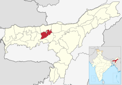
 Darrang district's location in Assam | |
| Country | |
| State | అసోం |
| ప్రధాన కార్యాలయం | Mangaldoi |
| Population (2011) | |
| • Total | 9,08,090 |
| Time zone | UTC+05:30 (IST) |
| ISO 3166 code | IN-AS-DA |
| Website | http://darrang.gov.in/ |
అస్సాం రాష్ట్ర 27 జిల్లాలలో దర్రాంగ్ జిల్లా (అస్సాం: দৰং) జిల్లా ఒకటి. జిల్లా కేంద్రంగా మంగళ్డోయీ పట్టణం ఉంది. జిల్లా వైశాల్యం 3481 చ.కి.మీ..
చరిత్ర[మార్చు]
1983లో దరాంగ్ జిల్లా నుండి సోనిత్పూర్ జిల్లా ఏర్పాటు చేయబడింది.[1] తరువాత 2004 జూన్ 14 న ఉదల్గురి జిల్లా రూపొందింది[1]
భౌగోళికం[మార్చు]
దర్రాంగ్ జిల్లా వైశాల్యం 348చ.కిమీ.[2]
అభయారణ్యం[మార్చు]
- మనాస్ పార్క్ (కొంతభాగం)
- ఒరంగ్ నేషనల్ పార్క్ (కొంతభాగం)
విభాగాలు[మార్చు]
జిల్లాలో 4 అసింబ్లీ నియోజకవర్గాలు ఉన్నాయి: కలైగయాన్, సిపఝర్, మంగల్డోయి, డాల్గయాన్.[3] మంగళ్డొయీ షెడ్యూల్డ్ కులాలకు ప్రత్యేకించబడింది.[4]
2001 లో గణాంకాలు[మార్చు]
| విషయాలు | వివరణలు |
|---|---|
| జిల్లా జనసంఖ్య . | 908,090, [5] |
| ఇది దాదాపు. | ఫిజి దేశ జనసంఖ్యకు సమానం.[6] |
| అమెరికాలోని. | డెలావర్ నగర జనసంఖ్యకు సమం.[7] |
| 640 భారతదేశ జిల్లాలలో. | 463 వ స్థానంలో ఉంది.[5] |
| 1చ.కి.మీ జనసాంద్రత. | 491 [5] |
| 2001-11 కుటుంబనియంత్రణ శాతం. | 19.51%.[5] |
| స్త్రీ పురుష నిష్పత్తి. | 923:1000 [5] |
| జాతియ సరాసరి (928) కంటే. | తక్కువ |
| అక్షరాస్యత శాతం. | 64.55%.[5] |
| జాతియ సరాసరి (72%) కంటే. | తక్కువ |
| ముస్లిములు | 534,658 (35.54%) |
| హిందువులు | 868,532 (57.74%) |
| క్రైస్తవులు | 97,306 (1.75%) [8] |
వృక్షజాలం, జంతుజాలం[మార్చు]
1990లో దర్రాంగ్ జిల్లాలో 500 చ.కి.మీ వైశాల్యంలో " మానస్ నేషనల్ పార్క్ " ఏర్పాటు చేయబడింది.[9] ఇది ఈ పార్కును 4 ఇతర జిల్లాలతో పంచుకుంటుంది. జీల్లాలో అదనంగా " ఒరంగ్ నేషనల్ పార్క్ " ఉంది. దీనీని సోనిత్పూర్ జిల్లాతో పంచుకుంటుంది. ఒరంగ్ 1999లో 79చ.కి.మీ వైశాల్యంలో స్థాపించబడింది.[9] నేషనల్ పార్కులతో జిల్లాలో బర్రాండి వద్ద " విల్డ్లైఫ్ శాంక్చ్యురీ " ఉంది.[9]
మూలాలు[మార్చు]
- ↑ 1.0 1.1 Law, Gwillim (2011-09-25). "Districts of India". Statoids. Retrieved 2011-10-11.
- ↑ Srivastava, Dayawanti (2010). "States and Union Territories: Assam: Government". India 2010: A Reference Annual (54th ed.). New Delhi, India: Additional Director General, Publications Division, Ministry of Information and Broadcasting (India), Government of India. pp. 1116. ISBN 978-81-230-1617-7. Retrieved 2011-10-11.
- ↑ "List of Assembly Constituencies showing their Revenue & Election District wise break - up" (PDF). Chief Electoral Officer, Assam website. Archived from the original (PDF) on 22 మార్చి 2012. Retrieved 26 September 2011.
- ↑ "List of Assembly Constituencies showing their Parliamentary Constituencies wise break - up" (PDF). Chief Electoral Officer, Assam website. Archived from the original (PDF) on 22 మార్చి 2012. Retrieved 26 September 2011.
- ↑ 5.0 5.1 5.2 5.3 5.4 5.5 "District Census 2011". Census2011.co.in. 2011. Retrieved 2011-09-30.
- ↑ US Directorate of Intelligence. "Country Comparison:Population". Archived from the original on 2011-09-27. Retrieved 2011-10-01.
Fiji 883,125 July 2011 est.
- ↑ "2010 Resident Population Data". U. S. Census Bureau. Archived from the original on 2011-08-23. Retrieved 2011-09-30.
Delaware 897,934
- ↑ "Demographic Features of the District". Archived from the original on 2009-03-07. Retrieved 2009-10-19.
- ↑ 9.0 9.1 9.2 Indian Ministry of Forests and Environment. "Protected areas: Assam". Archived from the original on 2011-08-23. Retrieved September 25, 2011.
భౌగోళిక స్థానం[మార్చు]
వెలుపలి లింకులు[మార్చు]