దస్త్రం:1700 CE world map.PNG
Jump to navigation
Jump to search

ఈ మునుజూపు పరిమాణం: 800 × 397 పిక్సెళ్ళు. ఇతర రిజల్యూషన్లు: 320 × 159 పిక్సెళ్ళు | 640 × 318 పిక్సెళ్ళు | 1,024 × 508 పిక్సెళ్ళు | 1,280 × 635 పిక్సెళ్ళు | 2,560 × 1,271 పిక్సెళ్ళు | 4,500 × 2,234 పిక్సెళ్ళు.
అసలు దస్త్రం (4,500 × 2,234 పిక్సెళ్ళు, ఫైలు పరిమాణం: 364 KB, MIME రకం: image/png)
This is a file from the Wikimedia Commons. Information from its description page there is shown below. Commons is a freely licensed media file repository. You can help. |
సారాంశం
| వివరణ |
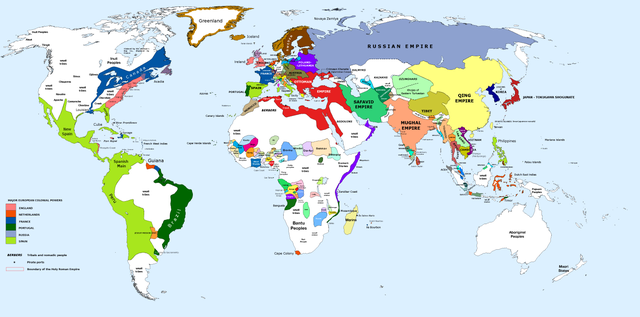
English: 1700 AD: An illustrative map of the world in the early colonial period. The Mughal Empire in India is at its greatest territorial extent. |
||
| తేదీ | |||
| మూలం | Own work. Blank map from File:World_Map_Blank.svg. | ||
| కర్త | Urnanabha | ||
| ఇతర కూర్పులు |
|

| Maps of world history | |
| BC | |
|
| |
| AD |
1 · 50 · 100 · 200 · 250 · 300 · 400 · 500 · 700 · 750 · 820 · 900 · 1200 · 1500 · 1556 · 1648 · 1700 · 1750 · 1815 · 1859 · 1871 · 1914 · 1935 · 1954 · 1989 · 2000 · |
|
Maps of colonization history | |
|
see also: Eastern Hemisphere only maps template (1300BC-1500AD) | |
| (this template: · view · discuss ) | |
.jpg)
._LOC_2001620596.jpg)
లైసెన్సింగ్
నేను, ఈ కృతి యొక్క కాపీహక్కుదారుని, దీన్ని ఈ లైసెన్సు క్రింద ఇందుమూలముగా ప్రచురిస్తున్నాను:
ఈ దస్త్రం క్రియేటివ్ కామన్స్ Attribution-Share Alike 3.0 Unported లైసెన్సు క్రింద లభ్యం.
- ఇలా చేసేందుకు మీకు స్వేచ్ఛ ఉంది:
- పంచుకోడానికి – ఈ కృతిని కాపీ చేసుకోవచ్చు, పంపిణీ చేయవచ్చు, ప్రసారమూ చేయవచ్చు
- రీమిక్స్ చేయడానికి – కృతిని అనుకరించడానికి
- క్రింది షరతులకు లోబడి:
- ఆపాదింపు – సముచితమైన శ్రేయస్సును ఇవ్వాలి, లైసెన్సుకు లింకు ఇవ్వాలి, మార్పులేమైనా చేస్తే వాటిని సూచించాలి. అందుకు సముచితమైన పద్ధతి దేన్నైనా అవలంబించవచ్చు. కానీ మీకూ మీ వాడుకకూ హక్కుదారు అనుమతించారు అనే అర్థం వచ్చేటట్లుగా మాత్రం కాదు.
- share alike – మీరు ఈ కృతిని అనుకరిస్తే, మారిస్తే, లేదా మెరుగుపరిస్తే తత్ఫలిత కృతిని ఇదే లైసెన్సు లేదా దీనికి అనుగుణ్యమైన లైసెన్సు క్రింద మాత్రమే పంపిణీ చేయాలి.
ఫైలు చరితం
తేదీ/సమయం ను నొక్కి ఆ సమయాన ఫైలు ఎలా ఉండేదో చూడవచ్చు.
| తేదీ/సమయం | నఖచిత్రం | కొలతలు | వాడుకరి | వ్యాఖ్య | |
|---|---|---|---|---|---|
| ప్రస్తుత | 10:00, 29 మార్చి 2023 | | 4,500 × 2,234 (364 KB) | Yourlocallordandsavior | Slightly adjusted Mainland SE Asia borders. |
| 01:49, 28 ఫిబ్రవరి 2019 |  | 4,500 × 2,234 (380 KB) | KnightxxArrow | Fixed inaccurate Cambodian border. | |
| 22:37, 4 ఏప్రిల్ 2017 |  | 4,500 × 2,234 (401 KB) | Chamboz | Fixed wildly inaccurate Ottoman southern border. | |
| 00:10, 26 జనవరి 2014 |  | 4,500 × 2,234 (328 KB) | Ukabia | Added states | |
| 21:31, 24 జనవరి 2014 |  | 4,500 × 2,234 (38.36 MB) | Ukabia | Added African states | |
| 05:36, 13 జనవరి 2013 |  | 4,500 × 2,234 (325 KB) | Urnanabha | User created page with UploadWizard |
లింకులు
కింది పేజీలలో ఈ ఫైలుకు లింకులు ఉన్నాయి:
సార్వత్రిక ఫైలు వాడుక
ఈ దస్త్రాన్ని ఈ క్రింది ఇతర వికీలు ఉపయోగిస్తున్నాయి:
- azb.wikipedia.org లో వాడుక
- bs.wikipedia.org లో వాడుక
- ce.wikipedia.org లో వాడుక
- de.wikipedia.org లో వాడుక
- en.wikipedia.org లో వాడుక
- eo.wikipedia.org లో వాడుక
- es.wikipedia.org లో వాడుక
- et.wikipedia.org లో వాడుక
- eu.wikipedia.org లో వాడుక
- fi.wikipedia.org లో వాడుక
- fr.wikipedia.org లో వాడుక
- gl.wikipedia.org లో వాడుక
- he.wikipedia.org లో వాడుక
- hy.wikipedia.org లో వాడుక
- id.wikipedia.org లో వాడుక
- io.wikipedia.org లో వాడుక
- it.wikipedia.org లో వాడుక
- it.wikiquote.org లో వాడుక
- ja.wikipedia.org లో వాడుక
- lv.wikipedia.org లో వాడుక
- my.wikipedia.org లో వాడుక
- pap.wikipedia.org లో వాడుక
- pnb.wikipedia.org లో వాడుక
- ro.wikipedia.org లో వాడుక
- ru.wikipedia.org లో వాడుక
- shn.wikipedia.org లో వాడుక
- ur.wikipedia.org లో వాడుక
- vi.wikipedia.org లో వాడుక