దస్త్రం:1864 Mitchell Map of India, Tibet, China and Southeast Asia - Geographicus - India-mitchell-1864.jpg
Jump to navigation
Jump to search

ఈ మునుజూపు పరిమాణం: 737 × 600 పిక్సెళ్ళు. ఇతర రిజల్యూషన్లు: 295 × 240 పిక్సెళ్ళు | 590 × 480 పిక్సెళ్ళు | 944 × 768 పిక్సెళ్ళు | 1,259 × 1,024 పిక్సెళ్ళు | 2,518 × 2,048 పిక్సెళ్ళు | 4,000 × 3,254 పిక్సెళ్ళు.
అసలు దస్త్రం (4,000 × 3,254 పిక్సెళ్ళు, ఫైలు పరిమాణం: 2.79 MB, MIME రకం: image/jpeg)
This is a file from the Wikimedia Commons. Information from its description page there is shown below. Commons is a freely licensed media file repository. You can help. |
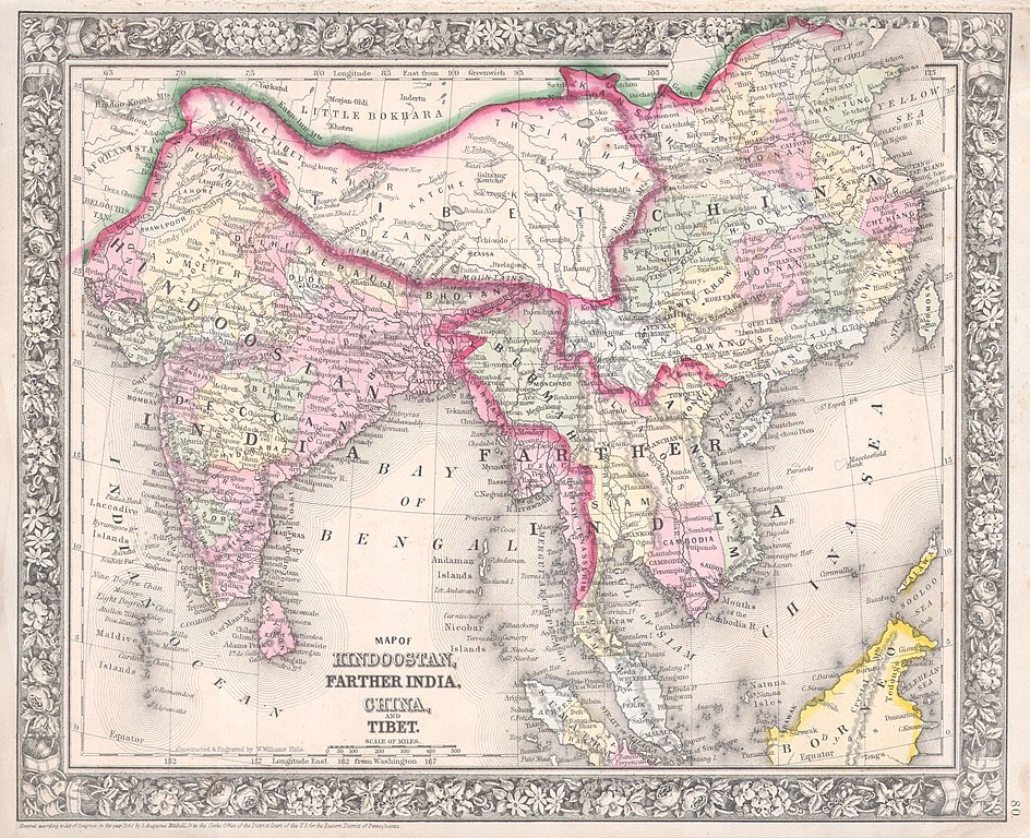
| Samuel Augustus Mitchell: Map of Hindoostan, Farther India, China, and Tibet.
( |
||||||||||||||||||||
|---|---|---|---|---|---|---|---|---|---|---|---|---|---|---|---|---|---|---|---|---|
| కృతికర్త |
|
|||||||||||||||||||
| శీర్షిక |
Map of Hindoostan, Farther India, China, and Tibet. |
|||||||||||||||||||
| వివరణ |
English: A beautiful example of S. A. Mitchell Jr.’s 1864 map of the India, Tibet, China and Southeast Asia, including Burma, Thailand, Cambodia, and Vietnam. Covers the region in considerable detail with parts of Malaysia, Sumatra, and Borneo included. One of the most attractive American atlas maps of this region to appear in the mid 19th century. Features the floral border typical of Mitchell maps from the 1860-65 period. Prepared by W. Williams for inclusion as plate 80 in the 1864 issue of Mitchell’s New General Atlas . Dated and copyrighted, “Entered according to Act of Congress in the Year 1860 by S. Augustus Mitchell in the Clerk’s Office of the District Court of the U.S. for the Eastern District of Pennsylvania. |
|||||||||||||||||||
| తేదీ | 1860 (dated) | |||||||||||||||||||
| కొలతలు | ఎత్తు: ౧౧.౫ in (౨౯.౨ cm); వెడల్పు: ౧౩.౭ in (౩౪.౯ cm) | |||||||||||||||||||
| Accession number |
Geographicus link: India-mitchell-1864 |
|||||||||||||||||||
| Source/Photographer |
Mitchell's New General Atlas, containing Maps of the Various Countries of the World, Plans of Cities, Etc., Embraced in Fifty-three Quarto Maps, forming a series of Eighty-Four Map and Plans, together with Valuable Statistical Tables. (1864 Edition)
|
|||||||||||||||||||
| అనుమతి (ఈ దస్త్రాన్ని పునర్వినియోగించుకోవడం) |
|
|||||||||||||||||||
| ఇతర కూర్పులు | ||||||||||||||||||||
.jpg)
ఫైలు చరితం
తేదీ/సమయం ను నొక్కి ఆ సమయాన ఫైలు ఎలా ఉండేదో చూడవచ్చు.
| తేదీ/సమయం | నఖచిత్రం | కొలతలు | వాడుకరి | వ్యాఖ్య | |
|---|---|---|---|---|---|
| ప్రస్తుత | 14:17, 16 మార్చి 2011 | | 4,000 × 3,254 (2.79 MB) | BotMultichill | {{subst:User:Multichill/Geographicus |link=http://www.geographicus.com/P/AntiqueMap/India-mitchell-1864 |product_name=1864 Mitchell Map of India, Tibet, China and Southeast Asia |map_title=Map of Hindoostan, Farther India, China, and Tibet. |description=A |
లింకులు
కింది పేజీలలో ఈ ఫైలుకు లింకులు ఉన్నాయి:
సార్వత్రిక ఫైలు వాడుక
ఈ దస్త్రాన్ని ఈ క్రింది ఇతర వికీలు ఉపయోగిస్తున్నాయి:
- ca.wikipedia.org లో వాడుక
- en.wikipedia.org లో వాడుక
- en.wiktionary.org లో వాడుక
- fr.wikipedia.org లో వాడుక
- hi.wikipedia.org లో వాడుక
- id.wikipedia.org లో వాడుక
- it.wikipedia.org లో వాడుక
- ms.wikipedia.org లో వాడుక
- nl.wikipedia.org లో వాడుక
- pt.wikipedia.org లో వాడుక
- sh.wikipedia.org లో వాడుక
- vi.wikipedia.org లో వాడుక
- zh.wikipedia.org లో వాడుక