దస్త్రం:2014 Russo-ukrainian-conflict map.svg
Jump to navigation
Jump to search

ఈ ఫైలు SVG కు చెందిన ఈ మునుజూపు PNG పరిమాణం: 552 × 599 పిక్సెళ్ళు. ఇతర రిజల్యూషన్లు: 221 × 240 పిక్సెళ్ళు | 442 × 480 పిక్సెళ్ళు | 707 × 768 పిక్సెళ్ళు | 943 × 1,024 పిక్సెళ్ళు | 1,886 × 2,048 పిక్సెళ్ళు | 4,126 × 4,480 పిక్సెళ్ళు.
అసలు దస్త్రం (SVG ఫైలు, నామమాత్రంగా 4,126 × 4,480 పిక్సెళ్ళు, ఫైలు పరిమాణం: 2.75 MB)
This is a file from the Wikimedia Commons. Information from its description page there is shown below. Commons is a freely licensed media file repository. You can help. |
సారాంశం
| వివరణ |
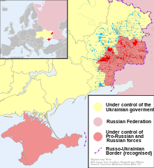
English: Map of the '2014 Russo-Ukrainian War', '2014 Russian invasion of Ukraine' or '2014 Russian military intervention in Ukraine'.
(Includes '2014 Crimean Crisis' and 'War in Donbass') |
| తేదీ | |
| మూలం | స్వంత కృతి |
| కర్త | Niele |
| ఇతర కూర్పులు |
[]
|
| SVG పెరుగుదల |


.png)


లైసెన్సింగ్
నేను, ఈ కృతి యొక్క కాపీహక్కుదారుని, దీన్ని ఈ లైసెన్సు క్రింద ఇందుమూలముగా ప్రచురిస్తున్నాను:
This file is licensed under the Creative Commons Attribution-Share Alike 4.0 International license.
- ఇలా చేసేందుకు మీకు స్వేచ్ఛ ఉంది:
- పంచుకోడానికి – ఈ కృతిని కాపీ చేసుకోవచ్చు, పంపిణీ చేయవచ్చు, ప్రసారమూ చేయవచ్చు
- రీమిక్స్ చేయడానికి – కృతిని అనుకరించడానికి
- క్రింది షరతులకు లోబడి:
- ఆపాదింపు – సముచితమైన శ్రేయస్సును ఇవ్వాలి, లైసెన్సుకు లింకు ఇవ్వాలి, మార్పులేమైనా చేస్తే వాటిని సూచించాలి. అందుకు సముచితమైన పద్ధతి దేన్నైనా అవలంబించవచ్చు. కానీ మీకూ మీ వాడుకకూ హక్కుదారు అనుమతించారు అనే అర్థం వచ్చేటట్లుగా మాత్రం కాదు.
- share alike – మీరు ఈ కృతిని అనుకరిస్తే, మారిస్తే, లేదా మెరుగుపరిస్తే తత్ఫలిత కృతిని ఇదే లైసెన్సు లేదా దీనికి అనుగుణ్యమైన లైసెన్సు క్రింద మాత్రమే పంపిణీ చేయాలి.
ఫైలు చరితం
తేదీ/సమయం ను నొక్కి ఆ సమయాన ఫైలు ఎలా ఉండేదో చూడవచ్చు.
| తేదీ/సమయం | నఖచిత్రం | కొలతలు | వాడుకరి | వ్యాఖ్య | |
|---|---|---|---|---|---|
| ప్రస్తుత | 16:03, 9 అక్టోబరు 2014 | | 4,126 × 4,480 (2.75 MB) | Mondolkiri1 | Marinka and Novotroitske - http://militarymaps.info/ |
| 03:27, 9 అక్టోబరు 2014 |  | 4,126 × 4,480 (2.75 MB) | Mondolkiri1 | Update according to http://militarymaps.info/ and other sources provided in File:East Ukraine Conflict.svg | |
| 23:30, 6 అక్టోబరు 2014 |  | 4,126 × 4,480 (2.74 MB) | Mondolkiri1 | Corrected Zolote and added Novoslapa | |
| 23:20, 6 అక్టోబరు 2014 |  | 4,126 × 4,480 (2.74 MB) | Mondolkiri1 | Update according to http://militarymaps.info/ , http://www.segodnya.ua/regions/donetsk/moskal-boeviki-obyavili-na-menya-ohotu-558223.html and other sources in my talk page | |
| 07:13, 5 అక్టోబరు 2014 |  | 4,126 × 4,480 (2.74 MB) | Mondolkiri1 | Update Donbass according to File:East Ukraine Conflict.svg | |
| 17:50, 19 సెప్టెంబరు 2014 |  | 4,126 × 4,480 (2.73 MB) | Hanibal911 | POV Vandalism I revert all unjustified changes which was made based unreliable sources | |
| 07:46, 19 సెప్టెంబరు 2014 |  | 4,126 × 4,480 (2.71 MB) | Niele~commonswiki | - Added Lutuhyne tot the red area as suggested by user Mondolkiri1 - Updated legenda and unclear/conflicting report-colours. This was a constructive way to prevent discussions, edit warring on basis of conflicting sources | |
| 13:26, 18 సెప్టెంబరు 2014 |  | 4,126 × 4,480 (2.73 MB) | Hanibal911 | POV Pushing we not use this not correct maps which contradicts to many sources | |
| 13:01, 18 సెప్టెంబరు 2014 |  | 4,126 × 4,480 (2.7 MB) | Niele~commonswiki | Not true, http://mediarnbo.org/ is the official communication-website of Ukrainean Forces, while http://liveuamap.com is unofficial map hosted from the us.Reverted to version as of 12:40, 18 September 2014 | |
| 12:44, 18 సెప్టెంబరు 2014 |  | 4,126 × 4,480 (2.73 MB) | Mondolkiri1 | Reverted to version as of 12:32, 18 September 2014 Sorry, but the http://liveuamap.com/ is the official Ukrainian ATO site, and as I said, Lutuhyne is in the pink area there, not in the foggy zone! |
లింకులు
కింది పేజీలలో ఈ ఫైలుకు లింకులు ఉన్నాయి:
సార్వత్రిక ఫైలు వాడుక
ఈ దస్త్రాన్ని ఈ క్రింది ఇతర వికీలు ఉపయోగిస్తున్నాయి:
- af.wikipedia.org లో వాడుక
- bn.wikipedia.org లో వాడుక
- cs.wikipedia.org లో వాడుక
- de.wikipedia.org లో వాడుక
- en.wikipedia.org లో వాడుక
- fi.wikipedia.org లో వాడుక
- he.wikipedia.org లో వాడుక
- incubator.wikimedia.org లో వాడుక
- it.wikiquote.org లో వాడుక
- ja.wikipedia.org లో వాడుక
- ka.wikipedia.org లో వాడుక
- lv.wikipedia.org లో వాడుక
- mk.wikipedia.org లో వాడుక
- ne.wikipedia.org లో వాడుక
- nl.wikipedia.org లో వాడుక
- pt.wikipedia.org లో వాడుక
- ru.wikinews.org లో వాడుక
- ru.wikiquote.org లో వాడుక
- sd.wikipedia.org లో వాడుక
- uk.wikipedia.org లో వాడుక
- uk.wikiquote.org లో వాడుక
- vi.wikipedia.org లో వాడుక