దస్త్రం:Adelaide metropolitan area map.svg
Jump to navigation
Jump to search

ఈ ఫైలు SVG కు చెందిన ఈ మునుజూపు PNG పరిమాణం: 246 × 599 పిక్సెళ్ళు. ఇతర రిజల్యూషన్లు: 98 × 240 పిక్సెళ్ళు | 197 × 480 పిక్సెళ్ళు | 315 × 768 పిక్సెళ్ళు | 420 × 1,024 పిక్సెళ్ళు | 840 × 2,048 పిక్సెళ్ళు | 974 × 2,373 పిక్సెళ్ళు.
అసలు దస్త్రం (SVG ఫైలు, నామమాత్రంగా 974 × 2,373 పిక్సెళ్ళు, ఫైలు పరిమాణం: 298 KB)
This is a file from the Wikimedia Commons. Information from its description page there is shown below. Commons is a freely licensed media file repository. You can help. |
సారాంశం
| వివరణ |
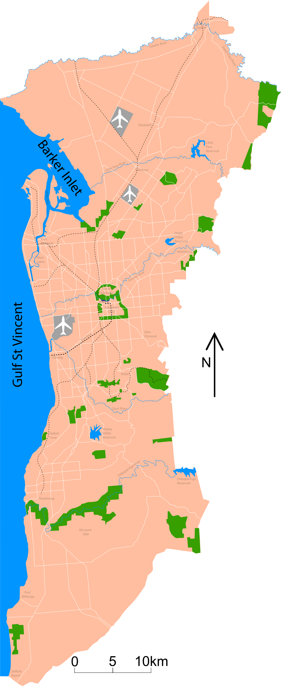
Map of Adelaide Shows major roads (per gregory's 2004 street directory), airports (adelaide, parafield and edinburgh airforce base) and all public reserves or parks > about 130 acres. Council district maps dated from 2004->2007 used to determine the landward boundary |
| తేదీ | |
| మూలం | స్వంత కృతి |
| కర్త | Peripitus |
| SVG పెరుగుదల | This map was created with Adobe Illustrator. |
లైసెన్సింగ్
నేను, ఈ కృతి యొక్క కాపీహక్కుదారుని, దీన్ని ఇందుమూలముగా ఈ లైసెన్సుల క్రింద ప్రచురిస్తున్నాను:

|
ఈ కృతి యొక్క కర్తనైన నేను, ఇక నుండీ ఈ కృతిని కాపీ చేసుకోవడానికి, పంచి పెట్టడానికి మరియు/లేదా మార్పులు-చేర్పులు చేసుకోవడానికి GFDL, లైసెన్సు వెర్షను 1.2 లేదా దాని తరువాత స్వేచ్చా సాఫ్టువేరు ఫౌండేషను విడుదలచేసే ఏ GFDL లైసెన్సు ద్వారా నయినా అనుమతి ఇస్తున్నాను; ఈ కృతిలో మార్చకూడని బాగాలు లేవు, Front-Cover పాఠం లేదు, Back-Cover పాఠం లేదు. ఈ లైసెన్సు యొక్క పత్రం నకలును "జిఎన్యూ ఉచిత డాక్యుమెంటేషను లైసెన్సు" అని పిలుస్తున్న విభాగంలో ఉంది. |
ఈ దస్త్రం క్రియేటివ్ కామన్స్ ఆపాదింపు-యథాతథ పంచుకోలు 3.0 అన్పోర్టెడ్, 2.5 సాధారణం, 2.0 సాధారణం, 1.0 సాధారణం లైసెన్సుల క్రింద లభ్యం.
- ఇలా చేసేందుకు మీకు స్వేచ్ఛ ఉంది:
- పంచుకోడానికి – ఈ కృతిని కాపీ చేసుకోవచ్చు, పంపిణీ చేయవచ్చు, ప్రసారమూ చేయవచ్చు
- రీమిక్స్ చేయడానికి – కృతిని అనుకరించడానికి
- క్రింది షరతులకు లోబడి:
- ఆపాదింపు – సముచితమైన శ్రేయస్సును ఇవ్వాలి, లైసెన్సుకు లింకు ఇవ్వాలి, మార్పులేమైనా చేస్తే వాటిని సూచించాలి. అందుకు సముచితమైన పద్ధతి దేన్నైనా అవలంబించవచ్చు. కానీ మీకూ మీ వాడుకకూ హక్కుదారు అనుమతించారు అనే అర్థం వచ్చేటట్లుగా మాత్రం కాదు.
- share alike – మీరు ఈ కృతిని అనుకరిస్తే, మారిస్తే, లేదా మెరుగుపరిస్తే తత్ఫలిత కృతిని ఇదే లైసెన్సు లేదా దీనికి అనుగుణ్యమైన లైసెన్సు క్రింద మాత్రమే పంపిణీ చేయాలి.
పైవాటిలో మీకు నచ్చిన లైసెన్సునును ఎంచుకోవచ్చు.
ఫైలు చరితం
తేదీ/సమయం ను నొక్కి ఆ సమయాన ఫైలు ఎలా ఉండేదో చూడవచ్చు.
| తేదీ/సమయం | నఖచిత్రం | కొలతలు | వాడుకరి | వ్యాఖ్య | |
|---|---|---|---|---|---|
| ప్రస్తుత | 10:53, 26 జనవరి 2015 | 974 × 2,373 (298 KB) | Wereldburger758 | Valid SVG now. | |
| 02:45, 3 నవంబరు 2007 | 974 × 2,373 (331 KB) | Peripitus | {{Information |Description=Map of Adelaide Shows major roads (per gregory's 2004 street directory), airports (adelaide, parafield and edinburgh airforce base) and all public reserves or parks > about 130 acres. Council district maps dated from 2004->2007 | ||
| 09:13, 24 అక్టోబరు 2007 | 974 × 2,373 (136 KB) | Peripitus | {{Information |Description=Map of Adelaide Shows major roads (per gregory's 2004 street directory), airports (adelaide, parafield and edinburgh airforce base) and all public reserves or parks > about 130 acres. Council district maps dated from 2004->2007 | ||
| 21:32, 23 అక్టోబరు 2007 | 487 × 1,188 (144 KB) | Peripitus | {{Information |Description=Map of Adelaide Shows major roads (per gregory's 2004 street directory), airports (adelaide, parafield and edinburgh airforce base) and all public reserves or parks > about 130 acres. Council district maps dated from 2004->2007 | ||
| 13:38, 23 అక్టోబరు 2007 | 487 × 1,188 (145 KB) | Peripitus | {{Information |Description=Map of Adelaide Shows major roads (per gregory's 2004 street directory), airports (adelaide, parafield and edinburgh airforce base) and all public reserves or parks > about 130 acres. Council district maps dated from 2004->2007 | ||
| 13:35, 23 అక్టోబరు 2007 |  | 749 × 1,188 (145 KB) | Peripitus | Reverted to version as of 13:26, 23 October 2007 | |
| 13:34, 23 అక్టోబరు 2007 | 487 × 1,188 (166 KB) | Peripitus | {{Information |Description=Map of Adelaide Shows major roads (per gregory's 2004 street directory), airports (adelaide, parafield and edinburgh airforce base) and all public reserves or parks > about 130 acres. Council district maps dated from 2004->2007 | ||
| 13:26, 23 అక్టోబరు 2007 |  | 749 × 1,188 (145 KB) | Peripitus | {{Information |Description=Map of Adelaide Shows major roads (per gregory's 2004 street directory), airports (adelaide, parafield and edinburgh airforce base) and all public reserves or parks > about 130 acres. Council district maps dated from 2004->2007 |
లింకులు
ఈ ఫైలును వాడుతున్న పేజీలు లేవు.
సార్వత్రిక ఫైలు వాడుక
ఈ దస్త్రాన్ని ఈ క్రింది ఇతర వికీలు ఉపయోగిస్తున్నాయి:
- af.wikipedia.org లో వాడుక
- ckb.wikipedia.org లో వాడుక
- el.wikipedia.org లో వాడుక
- en.wikipedia.org లో వాడుక
- es.wikipedia.org లో వాడుక
- hr.wikipedia.org లో వాడుక
- ka.wikipedia.org లో వాడుక
- ms.wikipedia.org లో వాడుక
- ru.wikipedia.org లో వాడుక