దస్త్రం:Algeria pipelines map.jpg
Jump to navigation
Jump to search
ఈ మునుజూపు పరిమాణం: 624 × 599 పిక్సెళ్ళు. ఇతర రిజల్యూషన్లు: 250 × 240 పిక్సెళ్ళు | 500 × 480 పిక్సెళ్ళు | 832 × 799 పిక్సెళ్ళు.
అసలు దస్త్రం (832 × 799 పిక్సెళ్ళు, ఫైలు పరిమాణం: 203 KB, MIME రకం: image/jpeg)
This is a file from the Wikimedia Commons. Information from its description page there is shown below. Commons is a freely licensed media file repository. You can help. |

|
This economic map image could be re-created using vector graphics as an SVG file. This has several advantages; see Commons:Media for cleanup for more information. If an SVG form of this image is available, please upload it and afterwards replace this template with
{{vector version available|new image name}}.
It is recommended to name the SVG file “Algeria pipelines map.svg”—then the template Vector version available (or Vva) does not need the new image name parameter. |


| వివరణ |
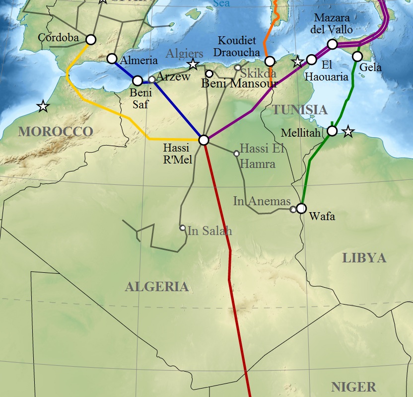
English: Map of gas pipelines across Mediterranee and Sahara : Trans-Saharan, Maghreb–Europe, Medgaz, Galsi, Trans-Mediterranean and Greenstream. Français : Carte des gazoducs traversant le Sahara et la Méditerranée : Trans-saharien, Maghreb–Europe, Gazoduc Medgaz, Galsi, Trans-Méditerranéen et Greenstream. |
| తేదీ | (UTC) |
| మూలం | |
| కర్త |
|
| This is a retouched picture, which means that it has been digitally altered from its original version. Modifications: Algeria pipelines. The original can be viewed here: Gas pipelines across Mediterranee and Sahara map-en.svg:
|
నేను, ఈ కృతి యొక్క కాపీహక్కుదారుని, దీన్ని ఇందుమూలముగా ఈ లైసెన్సుల క్రింద ప్రచురిస్తున్నాను:
ఈ దస్త్రం క్రియేటివ్ కామన్స్ ఆపాదింపు-యథాతథ పంచుకోలు 3.0 అన్పోర్టెడ్, 2.5 సాధారణం, 2.0 సాధారణం, 1.0 సాధారణం లైసెన్సుల క్రింద లభ్యం.
- ఇలా చేసేందుకు మీకు స్వేచ్ఛ ఉంది:
- పంచుకోడానికి – ఈ కృతిని కాపీ చేసుకోవచ్చు, పంపిణీ చేయవచ్చు, ప్రసారమూ చేయవచ్చు
- రీమిక్స్ చేయడానికి – కృతిని అనుకరించడానికి
- క్రింది షరతులకు లోబడి:
- ఆపాదింపు – సముచితమైన శ్రేయస్సును ఇవ్వాలి, లైసెన్సుకు లింకు ఇవ్వాలి, మార్పులేమైనా చేస్తే వాటిని సూచించాలి. అందుకు సముచితమైన పద్ధతి దేన్నైనా అవలంబించవచ్చు. కానీ మీకూ మీ వాడుకకూ హక్కుదారు అనుమతించారు అనే అర్థం వచ్చేటట్లుగా మాత్రం కాదు.
- share alike – మీరు ఈ కృతిని అనుకరిస్తే, మారిస్తే, లేదా మెరుగుపరిస్తే తత్ఫలిత కృతిని ఇదే లైసెన్సు లేదా దీనికి అనుగుణ్యమైన లైసెన్సు క్రింద మాత్రమే పంపిణీ చేయాలి.

|
ఈ కృతి యొక్క కర్తనైన నేను, ఇక నుండీ ఈ కృతిని కాపీ చేసుకోవడానికి, పంచి పెట్టడానికి మరియు/లేదా మార్పులు-చేర్పులు చేసుకోవడానికి GFDL, లైసెన్సు వెర్షను 1.2 లేదా దాని తరువాత స్వేచ్చా సాఫ్టువేరు ఫౌండేషను విడుదలచేసే ఏ GFDL లైసెన్సు ద్వారా నయినా అనుమతి ఇస్తున్నాను; ఈ కృతిలో మార్చకూడని బాగాలు లేవు, Front-Cover పాఠం లేదు, Back-Cover పాఠం లేదు. ఈ లైసెన్సు యొక్క పత్రం నకలును "జిఎన్యూ ఉచిత డాక్యుమెంటేషను లైసెన్సు" అని పిలుస్తున్న విభాగంలో ఉంది. |
పైవాటిలో మీకు నచ్చిన లైసెన్సునును ఎంచుకోవచ్చు.
అసలు ఎక్కింపుల చిట్టా
This image is a derivative work of the following images:
- File:Gas_pipelines_across_Mediterranee_and_Sahara_map-en.svg licensed with Cc-by-sa-3.0,2.5,2.0,1.0, GFDL
- 2009-07-15T14:34:38Z Sémhur 832x1573 (3945956 Bytes) {{Information |Description= {{en|1=Map of gas pipelines across Mediterranee and Sahara : [[:en:Trans-Saharan gas pipeline|Trans-Saharan]], [[:en:Maghreb–Europe Gas Pipeline|Maghreb–Europe]], [[:en:Medgaz|Medgaz]], [[:en:G
Uploaded with derivativeFX
ఫైలు చరితం
తేదీ/సమయం ను నొక్కి ఆ సమయాన ఫైలు ఎలా ఉండేదో చూడవచ్చు.
| తేదీ/సమయం | నఖచిత్రం | కొలతలు | వాడుకరి | వ్యాఖ్య | |
|---|---|---|---|---|---|
| ప్రస్తుత | 12:08, 6 మార్చి 2011 | | 832 × 799 (203 KB) | Mahmoudb1953 | {{Information |Description={{en|1=Map of gas pipelines across Mediterranee and Sahara : Trans-Saharan, Maghreb–Europe, Medgaz, Galsi, [[:en:Trans-Medit |
లింకులు
కింది పేజీలలో ఈ ఫైలుకు లింకులు ఉన్నాయి:
సార్వత్రిక ఫైలు వాడుక
ఈ దస్త్రాన్ని ఈ క్రింది ఇతర వికీలు ఉపయోగిస్తున్నాయి:
- ar.wikipedia.org లో వాడుక
- be-tarask.wikipedia.org లో వాడుక
- be.wikipedia.org లో వాడుక
- bs.wikipedia.org లో వాడుక
- ca.wikipedia.org లో వాడుక
- cy.wikipedia.org లో వాడుక
- de.wikipedia.org లో వాడుక
- el.wikipedia.org లో వాడుక
- en.wikipedia.org లో వాడుక
- eo.wikipedia.org లో వాడుక
- es.wikipedia.org లో వాడుక
- eu.wikipedia.org లో వాడుక
- fr.wikipedia.org లో వాడుక
- hu.wikipedia.org లో వాడుక
- id.wikipedia.org లో వాడుక
- ja.wikipedia.org లో వాడుక
- ka.wikipedia.org లో వాడుక
- lt.wikipedia.org లో వాడుక
- nl.wikipedia.org లో వాడుక
- pt.wikipedia.org లో వాడుక
- ru.wikipedia.org లో వాడుక
- si.wikipedia.org లో వాడుక
- sl.wikipedia.org లో వాడుక
- tum.wikipedia.org లో వాడుక
- uk.wikipedia.org లో వాడుక
- uz.wikipedia.org లో వాడుక
- www.wikidata.org లో వాడుక