దస్త్రం:Amazonie deforestation.jpg
Jump to navigation
Jump to search
ఈ మునుజూపు పరిమాణం: 755 × 600 పిక్సెళ్ళు. ఇతర రిజల్యూషన్లు: 302 × 240 పిక్సెళ్ళు | 604 × 480 పిక్సెళ్ళు | 778 × 618 పిక్సెళ్ళు.
అసలు దస్త్రం (778 × 618 పిక్సెళ్ళు, ఫైలు పరిమాణం: 398 KB, MIME రకం: image/jpeg)
This is a file from the Wikimedia Commons. Information from its description page there is shown below. Commons is a freely licensed media file repository. You can help. |
సారాంశం
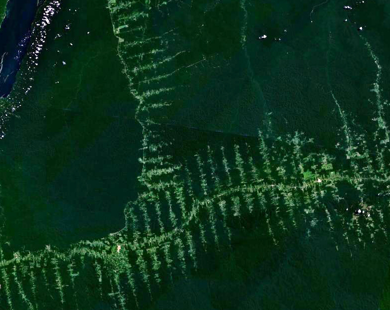
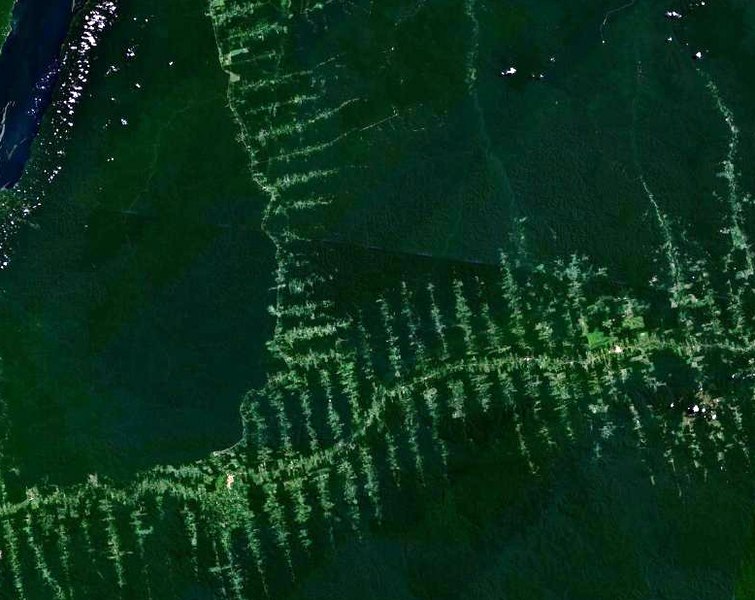
English: Deforestation in Amazonia, seen from satellite. The roads in the forest follow a typical "fish bone" pattern
Français : Déforestation en Amazonie, vu depuis un satellite. Les routes tracées dans la forêt suivent un motif caractéristique similaire à des arêtes de poisson
Deutsch: Entwaldung in Amazonien, aufgenommen vom Satelliten. Die in den Wald getriebenen Schneisen ergeben ein charakteristisches Fischgrätenmuster
లైసెన్సింగ్
| This file is in the public domain in the United States because it was solely created by NASA. NASA copyright policy states that "NASA material is not protected by copyright unless noted". (See Template:PD-USGov, NASA copyright policy page or JPL Image Use Policy.) | ||
 |
Warnings:
|
ఫైలు చరితం
తేదీ/సమయం ను నొక్కి ఆ సమయాన ఫైలు ఎలా ఉండేదో చూడవచ్చు.
| తేదీ/సమయం | నఖచిత్రం | కొలతలు | వాడుకరి | వ్యాఖ్య | |
|---|---|---|---|---|---|
| ప్రస్తుత | 20:02, 20 సెప్టెంబరు 2006 | | 778 × 618 (398 KB) | Dake~commonswiki | {{en|Deforestation in Amazonia, seen from satellite. The roads in the forest follow a typical "fishbone" pattern}} {{fr|Déforestation en Amazonie, vu depuis un satellite. Les routes tracées dans la forêt suivent un motif caractéristique similaire à |
లింకులు
ఈ ఫైలును వాడుతున్న పేజీలు లేవు.
సార్వత్రిక ఫైలు వాడుక
ఈ దస్త్రాన్ని ఈ క్రింది ఇతర వికీలు ఉపయోగిస్తున్నాయి:
- ar.wikipedia.org లో వాడుక
- bn.wikipedia.org లో వాడుక
- ca.wikipedia.org లో వాడుక
- chr.wikipedia.org లో వాడుక
- de.wikipedia.org లో వాడుక
- el.wikipedia.org లో వాడుక
- en.wikipedia.org లో వాడుక
- eo.wikipedia.org లో వాడుక
- es.wikipedia.org లో వాడుక
- eu.wikipedia.org లో వాడుక
- fr.wikipedia.org లో వాడుక
- gu.wikipedia.org లో వాడుక
- id.wikipedia.org లో వాడుక
- ja.wikipedia.org లో వాడుక
- nl.wikipedia.org లో వాడుక
- pa.wikipedia.org లో వాడుక
- pl.wikipedia.org లో వాడుక
- pt.wikipedia.org లో వాడుక
- ro.wikipedia.org లో వాడుక
- ru.wikipedia.org లో వాడుక
- sl.wikipedia.org లో వాడుక
- sq.wikipedia.org లో వాడుక
- ta.wikipedia.org లో వాడుక
- tr.wikipedia.org లో వాడుక
- vi.wikipedia.org లో వాడుక