దస్త్రం:Andorra topographic map-en.svg
Jump to navigation
Jump to search

ఈ ఫైలు SVG కు చెందిన ఈ మునుజూపు PNG పరిమాణం: 750 × 600 పిక్సెళ్ళు. ఇతర రిజల్యూషన్లు: 300 × 240 పిక్సెళ్ళు | 600 × 480 పిక్సెళ్ళు | 960 × 768 పిక్సెళ్ళు | 1,280 × 1,024 పిక్సెళ్ళు | 2,560 × 2,048 పిక్సెళ్ళు | 1,625 × 1,300 పిక్సెళ్ళు.
అసలు దస్త్రం (SVG ఫైలు, నామమాత్రంగా 1,625 × 1,300 పిక్సెళ్ళు, ఫైలు పరిమాణం: 1.56 MB)
This is a file from the Wikimedia Commons. Information from its description page there is shown below. Commons is a freely licensed media file repository. You can help. |
సారాంశం
| వివరణ |
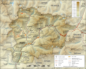
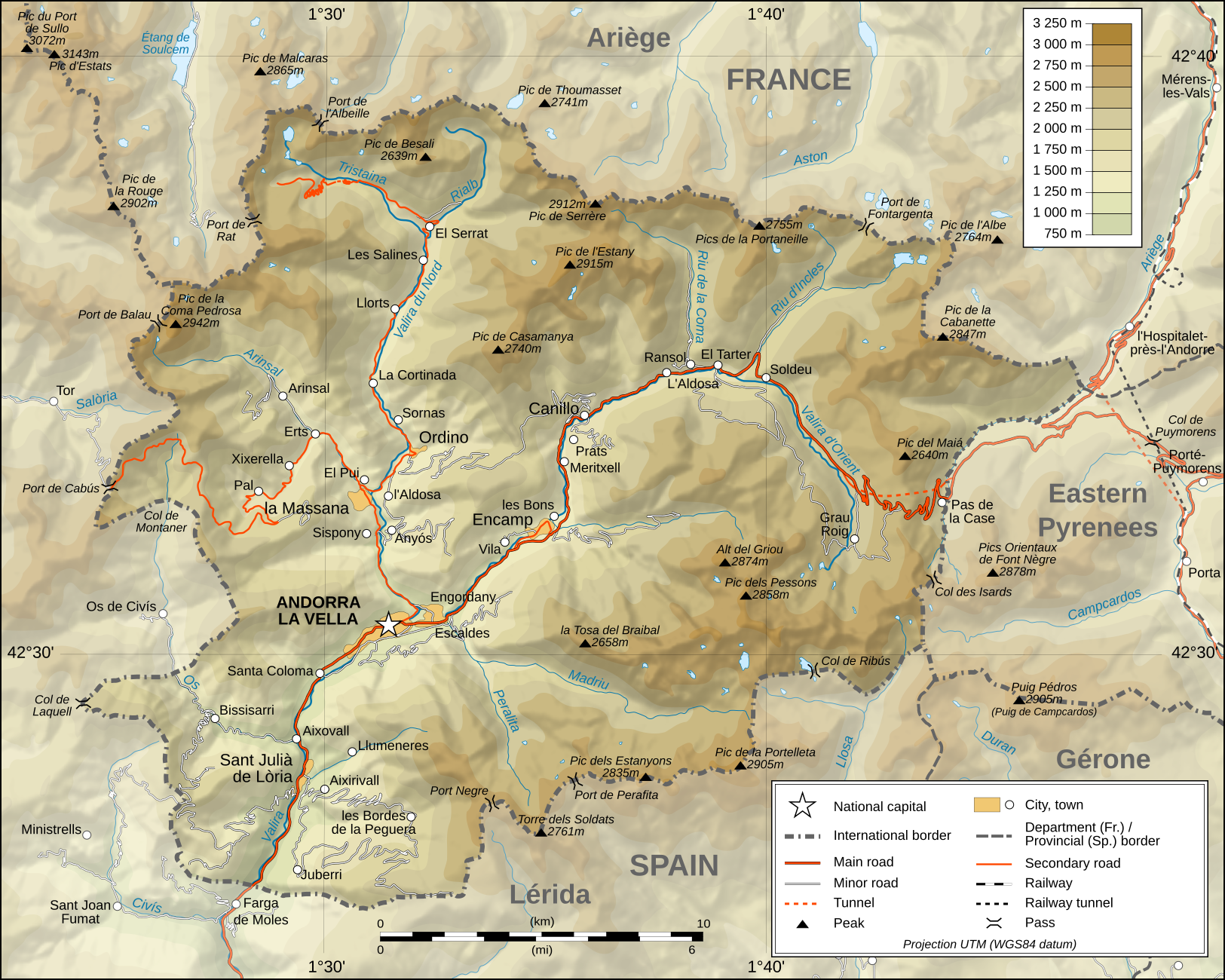
Deutsch: Topographische Karte von Andorra, englische Version English: Topographic map of Andorra Français : Carte topographique en anglais de l'Andorre |
| తేదీ | February 2008 (translation March 2009) |
| మూలం |
English: Own work ; Topographic data from the NASA Shuttle Radar Topography Mission (SRTM3 v.2) (public domain) edited with 3DEM and dlgv32 Pro and vectorized with Inkscape ; UTM projection ; WGS84 datum ; shaded relief (composite image of N-W, W and N lightning positions) ; Reference used for the additional data : * Topographic maps available on the site of the Ministeri d'Urbanisme i Ordenament Territorial of Andorra ; * Géoportail France ; Approximate scale of topographic data : 1:400,000 (accuracy : about 100 m) ; Note : The shaded relief is a raster image embedded in the SVG file. Français : Création personnelle ; Données topographiques de la NASA Shuttle Radar Topography Mission (SRTM3 v.2) (domaine public) éditées avec 3DEM et dlgv32 Pro et vectorisées avec Inkscape ; projection UTM ; WGS84 datum ; relief ombré (image composite d'éclairages du N-O, O et N) ; Références utilisées pour les données complémentaires : * Cartes topographiques disponibles sur le site du Ministeri d'Urbanisme i Ordenament Territorial d'Andorre ; * Géoportail France ; Échelle approximative des données topographiques : 1:400 000 (précision : environ 100 m) ; Note : Le relief ombré est une image bitmap embarquée dans le fichier SVG. Approximate geographic limits of the map (3" close) : * SW corner : 42°24'30"N – 01°22'40"E * SE corner : 42°24'30"N – 01°50'20"E * NE corner : 42°40'55"N – 01°50'25"E * NW corner : 42°40'55"N – 01°22'35"E |
| కర్త | Eric Gaba (Sting - fr:Sting), English translation: User:Goldsztajn |
| అనుమతి (ఈ దస్త్రాన్ని పునర్వినియోగించుకోవడం) |
GFDL / Attribution and Share-Alike required |
| ఇతర కూర్పులు |
[]
|


|
This SVG file contains embedded text that can be translated into your language, using any capable SVG editor, text editor or the SVG Translate tool. For more information see: About translating SVG files. |
లైసెన్సింగ్
నేను, ఈ కృతి యొక్క కాపీహక్కుదారుని, దీన్ని ఇందుమూలముగా ఈ లైసెన్సుల క్రింద ప్రచురిస్తున్నాను:

|
ఈ కృతి యొక్క కర్తనైన నేను, ఇక నుండీ ఈ కృతిని కాపీ చేసుకోవడానికి, పంచి పెట్టడానికి మరియు/లేదా మార్పులు-చేర్పులు చేసుకోవడానికి GFDL, లైసెన్సు వెర్షను 1.2 లేదా దాని తరువాత స్వేచ్చా సాఫ్టువేరు ఫౌండేషను విడుదలచేసే ఏ GFDL లైసెన్సు ద్వారా నయినా అనుమతి ఇస్తున్నాను; ఈ కృతిలో మార్చకూడని బాగాలు లేవు, Front-Cover పాఠం లేదు, Back-Cover పాఠం లేదు. ఈ లైసెన్సు యొక్క పత్రం నకలును "జిఎన్యూ ఉచిత డాక్యుమెంటేషను లైసెన్సు" అని పిలుస్తున్న విభాగంలో ఉంది. |
ఈ దస్త్రం క్రియేటివ్ కామన్స్ Attribution-Share Alike 3.0 Unported లైసెన్సు క్రింద లభ్యం.
- ఇలా చేసేందుకు మీకు స్వేచ్ఛ ఉంది:
- పంచుకోడానికి – ఈ కృతిని కాపీ చేసుకోవచ్చు, పంపిణీ చేయవచ్చు, ప్రసారమూ చేయవచ్చు
- రీమిక్స్ చేయడానికి – కృతిని అనుకరించడానికి
- క్రింది షరతులకు లోబడి:
- ఆపాదింపు – సముచితమైన శ్రేయస్సును ఇవ్వాలి, లైసెన్సుకు లింకు ఇవ్వాలి, మార్పులేమైనా చేస్తే వాటిని సూచించాలి. అందుకు సముచితమైన పద్ధతి దేన్నైనా అవలంబించవచ్చు. కానీ మీకూ మీ వాడుకకూ హక్కుదారు అనుమతించారు అనే అర్థం వచ్చేటట్లుగా మాత్రం కాదు.
- share alike – మీరు ఈ కృతిని అనుకరిస్తే, మారిస్తే, లేదా మెరుగుపరిస్తే తత్ఫలిత కృతిని ఇదే లైసెన్సు లేదా దీనికి అనుగుణ్యమైన లైసెన్సు క్రింద మాత్రమే పంపిణీ చేయాలి.
పైవాటిలో మీకు నచ్చిన లైసెన్సునును ఎంచుకోవచ్చు.
ఫైలు చరితం
తేదీ/సమయం ను నొక్కి ఆ సమయాన ఫైలు ఎలా ఉండేదో చూడవచ్చు.
| తేదీ/సమయం | నఖచిత్రం | కొలతలు | వాడుకరి | వ్యాఖ్య | |
|---|---|---|---|---|---|
| ప్రస్తుత | 01:34, 30 మార్చి 2009 | | 1,625 × 1,300 (1.56 MB) | Goldsztajn | {{Information |Description={{en|1=Map of Andorra}} |Source=http://commons.wikimedia.org/wiki/File:Andorra_topographic_map-fr.svg |Author=User:Sting fr:Utilisateur:Sting, english translation |Date=2009-03-30 |Permission= |other_versions= }} <!--{{ |
లింకులు
కింది పేజీలలో ఈ ఫైలుకు లింకులు ఉన్నాయి:
సార్వత్రిక ఫైలు వాడుక
ఈ దస్త్రాన్ని ఈ క్రింది ఇతర వికీలు ఉపయోగిస్తున్నాయి:
- af.wikipedia.org లో వాడుక
- ar.wikipedia.org లో వాడుక
- azb.wikipedia.org లో వాడుక
- bn.wikipedia.org లో వాడుక
- el.wikipedia.org లో వాడుక
- en.wikipedia.org లో వాడుక
- fa.wikipedia.org లో వాడుక
- fi.wikipedia.org లో వాడుక
- ga.wikipedia.org లో వాడుక
- gl.wikipedia.org లో వాడుక
- hr.wiktionary.org లో వాడుక
- id.wikipedia.org లో వాడుక
- is.wikipedia.org లో వాడుక
- ka.wikipedia.org లో వాడుక
- lt.wikipedia.org లో వాడుక
- ms.wikipedia.org లో వాడుక
- pnb.wikipedia.org లో వాడుక
- ro.wikipedia.org లో వాడుక
- ru.wikipedia.org లో వాడుక
- sv.wikipedia.org లో వాడుక
- trv.wikipedia.org లో వాడుక
- uk.wikipedia.org లో వాడుక
- vep.wikipedia.org లో వాడుక
- vi.wikipedia.org లో వాడుక
- www.wikidata.org లో వాడుక
- zh-min-nan.wikipedia.org లో వాడుక
- zh.wikipedia.org లో వాడుక