దస్త్రం:Baltoro region from space annotated.png
Jump to navigation
Jump to search

ఈ మునుజూపు పరిమాణం: 633 × 600 పిక్సెళ్ళు. ఇతర రిజల్యూషన్లు: 253 × 240 పిక్సెళ్ళు | 507 × 480 పిక్సెళ్ళు | 811 × 768 పిక్సెళ్ళు | 1,081 × 1,024 పిక్సెళ్ళు | 2,336 × 2,213 పిక్సెళ్ళు.
అసలు దస్త్రం (2,336 × 2,213 పిక్సెళ్ళు, ఫైలు పరిమాణం: 9.84 MB, MIME రకం: image/png)
This is a file from the Wikimedia Commons. Information from its description page there is shown below. Commons is a freely licensed media file repository. You can help. |
| వివరణ |
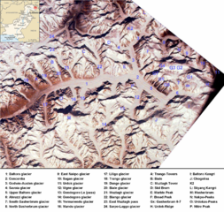
English: Baltoro region from space. Many mountains (e.g. K2, Broad Peak, Gasherbrums, Trango Towers) and glaciers are marked. |
| తేదీ |
(UTC) 2000-02-14 |
| మూలం | |
| కర్త |
|
| ఇతర కూర్పులు | Image:Baltororegion aus dem Weltraum - deutsch.png (deutsche Beschriftung - German Annotations) |
| This is a retouched picture, which means that it has been digitally altered from its original version. Modifications: ISS-image rotated, cropped, marked, pk-map.png included, region marked with a red circle. The original can be viewed here: Karakoram ISS.jpg:
|
| This is a retouched picture, which means that it has been digitally altered from its original version. Modifications: ISS-image rotated, cropped, marked, pk-map.png included, region marked with a red circle. The original can be viewed here: Pk-map.png:
|
ఈ దస్త్రం క్రియేటివ్ కామన్స్ Attribution-Share Alike 3.0 Unported లైసెన్సు క్రింద లభ్యం.
- ఇలా చేసేందుకు మీకు స్వేచ్ఛ ఉంది:
- పంచుకోడానికి – ఈ కృతిని కాపీ చేసుకోవచ్చు, పంపిణీ చేయవచ్చు, ప్రసారమూ చేయవచ్చు
- రీమిక్స్ చేయడానికి – కృతిని అనుకరించడానికి
- క్రింది షరతులకు లోబడి:
- ఆపాదింపు – సముచితమైన శ్రేయస్సును ఇవ్వాలి, లైసెన్సుకు లింకు ఇవ్వాలి, మార్పులేమైనా చేస్తే వాటిని సూచించాలి. అందుకు సముచితమైన పద్ధతి దేన్నైనా అవలంబించవచ్చు. కానీ మీకూ మీ వాడుకకూ హక్కుదారు అనుమతించారు అనే అర్థం వచ్చేటట్లుగా మాత్రం కాదు.
- share alike – మీరు ఈ కృతిని అనుకరిస్తే, మారిస్తే, లేదా మెరుగుపరిస్తే తత్ఫలిత కృతిని ఇదే లైసెన్సు లేదా దీనికి అనుగుణ్యమైన లైసెన్సు క్రింద మాత్రమే పంపిణీ చేయాలి.
అసలు ఎక్కింపుల చిట్టా
This image is a derivative work of the following images:
- Image:Pk-map.png licensed with PD-USGov-CIA-WF
- 2005-03-04T20:56:46Z Alfio 330x354 (14233 Bytes) CIA map of Pakistan
Uploaded with derivativeFX
ఫైలు చరితం
తేదీ/సమయం ను నొక్కి ఆ సమయాన ఫైలు ఎలా ఉండేదో చూడవచ్చు.
| తేదీ/సమయం | నఖచిత్రం | కొలతలు | వాడుకరి | వ్యాఖ్య | |
|---|---|---|---|---|---|
| ప్రస్తుత | 15:56, 21 నవంబరు 2008 | | 2,336 × 2,213 (9.84 MB) | Rupert Pupkin | {{Information |Description={{en|1=Baltoro region from space. Many mountains (e.g. K2, Broad Peak, Gasherbrums, Trango Towers) and glaciers are marked. |Source=*Image:Pk-map.png |Date=2008-11-21 15:50 (UTC) |Author=*derivative work: ~~~ *[[:Image:Pk- |
లింకులు
ఈ ఫైలును వాడుతున్న పేజీలు లేవు.
సార్వత్రిక ఫైలు వాడుక
ఈ దస్త్రాన్ని ఈ క్రింది ఇతర వికీలు ఉపయోగిస్తున్నాయి:
- arz.wikipedia.org లో వాడుక
- az.wikipedia.org లో వాడుక
- bn.wikipedia.org లో వాడుక
- ca.wikipedia.org లో వాడుక
- da.wikipedia.org లో వాడుక
- de.wikipedia.org లో వాడుక
- en.wikipedia.org లో వాడుక
- es.wikipedia.org లో వాడుక
- eu.wikipedia.org లో వాడుక
- fa.wikipedia.org లో వాడుక
- fr.wikipedia.org లో వాడుక
- gl.wikipedia.org లో వాడుక
- hi.wikipedia.org లో వాడుక
- hu.wikipedia.org లో వాడుక
- incubator.wikimedia.org లో వాడుక
- it.wikipedia.org లో వాడుక
- ja.wikipedia.org లో వాడుక
- ko.wikipedia.org లో వాడుక
- lld.wikipedia.org లో వాడుక
- mai.wikipedia.org లో వాడుక
ఈ దస్త్రపు మరింత సార్వత్రిక వాడుకను చూడండి.