దస్త్రం:British Decolonisation in Africa.png
Jump to navigation
Jump to search
ఈ మునుజూపు పరిమాణం: 600 × 600 పిక్సెళ్ళు. ఇతర రిజల్యూషన్లు: 240 × 240 పిక్సెళ్ళు | 480 × 480 పిక్సెళ్ళు | 768 × 768 పిక్సెళ్ళు | 1,024 × 1,024 పిక్సెళ్ళు | 2,000 × 2,000 పిక్సెళ్ళు.
అసలు దస్త్రం (2,000 × 2,000 పిక్సెళ్ళు, ఫైలు పరిమాణం: 406 KB, MIME రకం: image/png)
This is a file from the Wikimedia Commons. Information from its description page there is shown below. Commons is a freely licensed media file repository. You can help. |
సారాంశం

|
This historical map image could be re-created using vector graphics as an SVG file. This has several advantages; see Commons:Media for cleanup for more information. If an SVG form of this image is available, please upload it and afterwards replace this template with
{{vector version available|new image name}}.
It is recommended to name the SVG file “British Decolonisation in Africa.svg”—then the template Vector version available (or Vva) does not need the new image name parameter. |
| వివరణ |
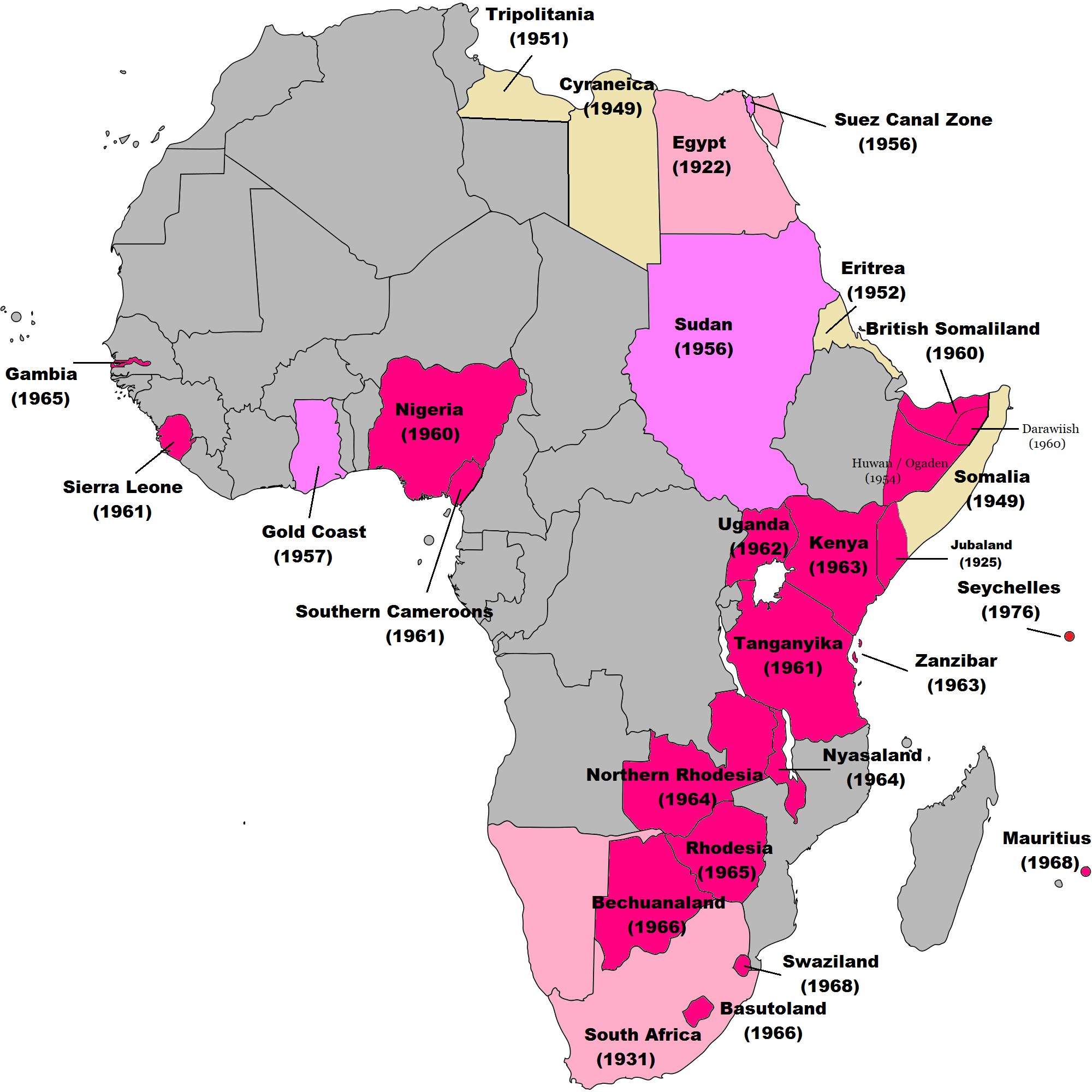
English: Map of British decolonisation in Africa. The beige areas were under British military administration after WW2. The different shades of pink refer to the stages of decolonization according to decades. |
| తేదీ | 1 నవంబరు 2008 (original upload date) |
| మూలం |
Transferred from en.wikipedia; transfer was stated to be made by User:Hejsa. Blank map from File:BlankMap-World3.svg . Original text:
|
| కర్త | The Red Hat of Pat Ferrick t (log) |
| అనుమతి (ఈ దస్త్రాన్ని పునర్వినియోగించుకోవడం) |
Released into the public domain (by the author). |
లైసెన్సింగ్
| |
ఈ కృతిని కృతికర్త, The Red Hat of Pat Ferrick, at the ఇంగ్లీష్ వికీపీడియా project, సార్వజనీనంగా విడుదల చేసారు. ఇది ప్రపంచవ్యాప్తంగా వర్తిస్తుంది. In case this is not legally possible: |
అసలు ఎక్కింపుల చిట్టా
The original description page was here. All following user names refer to en.wikipedia.
- 2008-11-02 00:56 The Red Hat of Pat Ferrick 757×785× (171674 bytes) {{Information |Description=Map of British decolonisation in Africa. |Source=I created this work entirely by myself. |Date=1 November 2008 |Author=~~~ |other_versions= }}
ఫైలు చరితం
తేదీ/సమయం ను నొక్కి ఆ సమయాన ఫైలు ఎలా ఉండేదో చూడవచ్చు.
| తేదీ/సమయం | నఖచిత్రం | కొలతలు | వాడుకరి | వ్యాఖ్య | |
|---|---|---|---|---|---|
| ప్రస్తుత | 08:49, 8 నవంబరు 2021 | | 2,000 × 2,000 (406 KB) | Randomastwritter | ogaden |
| 03:23, 30 అక్టోబరు 2021 |  | 2,000 × 2,000 (399 KB) | Randomastwritter | juba | |
| 01:38, 7 డిసెంబరు 2013 |  | 2,000 × 2,000 (396 KB) | Zello | corrected map that better reflects historical realities (for example South-West Africa, Rhodesia), also Mauritius and Seychelle added, and new colour for territories under temporary military administration after WW2 | |
| 18:52, 22 నవంబరు 2013 |  | 757 × 785 (159 KB) | Zello | Somalia became a UN Trust Territory under Italian administration in 1949. The correction was requested also on the talk page. | |
| 16:08, 13 సెప్టెంబరు 2009 |  | 757 × 785 (168 KB) | Hejsa | {{Information |Description={{en|Map of British decolonisation in Africa.}} |Source=Transferred from [http://en.wikipedia.org en.wikipedia]; transfer was stated to be made by User:Hejsa. |Date=1 November 2008<br/> ({{Date|2008|11|02}} (original upload |
లింకులు
ఈ ఫైలును వాడుతున్న పేజీలు లేవు.
సార్వత్రిక ఫైలు వాడుక
ఈ దస్త్రాన్ని ఈ క్రింది ఇతర వికీలు ఉపయోగిస్తున్నాయి:
- ar.wikipedia.org లో వాడుక
- ast.wikipedia.org లో వాడుక
- azb.wikipedia.org లో వాడుక
- az.wikipedia.org లో వాడుక
- ba.wikipedia.org లో వాడుక
- cs.wikipedia.org లో వాడుక
- da.wikipedia.org లో వాడుక
- de.wikipedia.org లో వాడుక
- el.wikipedia.org లో వాడుక
- en.wikipedia.org లో వాడుక
- eu.wikipedia.org లో వాడుక
- fr.wikipedia.org లో వాడుక
- fr.wikiversity.org లో వాడుక
- hy.wikipedia.org లో వాడుక
- id.wikipedia.org లో వాడుక
- it.wikipedia.org లో వాడుక
- ka.wikipedia.org లో వాడుక
- ko.wikipedia.org లో వాడుక
- lv.wikipedia.org లో వాడుక
- ms.wikipedia.org లో వాడుక
- nl.wikipedia.org లో వాడుక
- no.wikipedia.org లో వాడుక
- pl.wikipedia.org లో వాడుక
- pt.wikipedia.org లో వాడుక
- ru.wikipedia.org లో వాడుక
- th.wikipedia.org లో వాడుక
- tr.wikipedia.org లో వాడుక
- uk.wikipedia.org లో వాడుక
ఈ దస్త్రపు మరింత సార్వత్రిక వాడుకను చూడండి.