దస్త్రం:Chola map.png
Jump to navigation
Jump to search
మరింత స్పష్టమైన బొమ్మ లేదు.
Chola_map.png (503 × 425 పిక్సెళ్ళు, ఫైలు పరిమాణం: 78 KB, MIME రకం: image/png)
This is a file from the Wikimedia Commons. Information from its description page there is shown below. Commons is a freely licensed media file repository. You can help. |
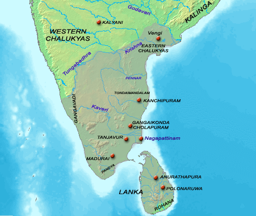
| వివరణ | Map showing the extent of the Chola empire during en:Rajaraja Chola I. | ||||||||
| మూలం |
Source of map: http://www2.demis.nl/mapserver/mapper.asp (mention : "Disclaimer: With this statement DEMIS BV grants you permission to freely copy the PNG images returned by our server and use them for your own purposes, including web pages. We would appreciate a reference to our server but such a reference is not required, nor do we take responsibility for the accuracy or quality of the maps". at http://www2.demis.nl/mapserver/DataSrc.htm) Modified by myself using Adobe Photoshop |
||||||||
| కర్త | User Venu62 on en.wikipedia | ||||||||
| అనుమతి (ఈ దస్త్రాన్ని పునర్వినియోగించుకోవడం) |
Venu62 from en.wikipedia.org, ఈ కృతి యొక్క కాపీహక్కుదారు, దీన్ని ఇందుమూలముగా ఈ లైసెన్సు క్రింద ప్రచురిస్తున్నారు:
|
||||||||
| ఇతర కూర్పులు |
Originally from en.wikipedia; description page is (was) here
|

ఫైలు చరితం
తేదీ/సమయం ను నొక్కి ఆ సమయాన ఫైలు ఎలా ఉండేదో చూడవచ్చు.
| తేదీ/సమయం | నఖచిత్రం | కొలతలు | వాడుకరి | వ్యాఖ్య | |
|---|---|---|---|---|---|
| ప్రస్తుత | 00:08, 28 జూన్ 2006 | | 503 × 425 (78 KB) | Nicke L | {{Information| |Description= == Summary == Map showing the extent of the Chola empire during en:Rajaraja Chola I. Source of map: http://www2.demis.nl/mapserver/mapper.asp (mention : "Disclaimer: With this statement DEMIS BV grants you permission to |
లింకులు
కింది పేజీలలో ఈ ఫైలుకు లింకులు ఉన్నాయి:
సార్వత్రిక ఫైలు వాడుక
ఈ దస్త్రాన్ని ఈ క్రింది ఇతర వికీలు ఉపయోగిస్తున్నాయి:
- ar.wikipedia.org లో వాడుక
- ast.wikipedia.org లో వాడుక
- ba.wikipedia.org లో వాడుక
- be.wikipedia.org లో వాడుక
- ca.wikipedia.org లో వాడుక
- de.wikipedia.org లో వాడుక
- en.wikipedia.org లో వాడుక
- Portal:India/Today's selected article/October 2006
- Portal:India/Today's selected article/December 2006
- Portal:India/Today's selected article/October 3, 2006
- Portal:India/Today's selected article/December 17, 2006
- Chola government
- Portal:India/SC Summary/SA Chola dynasty
- Parakramabahu I
- Portal:India/Today's selected article/March 2007
- Portal:India/Today's selected article/March 1, 2007
- Portal:India/Selected articles/Archive
- Talk:South India/Archive 2
- eo.wikipedia.org లో వాడుక
- fr.wikipedia.org లో వాడుక
- hu.wikipedia.org లో వాడుక
- id.wikipedia.org లో వాడుక
- id.wikibooks.org లో వాడుక
- it.wikipedia.org లో వాడుక
- ja.wikipedia.org లో వాడుక
- ko.wikipedia.org లో వాడుక
- ml.wikipedia.org లో వాడుక
- ms.wikipedia.org లో వాడుక
- pnb.wikipedia.org లో వాడుక
- si.wikipedia.org లో వాడుక
- sq.wikipedia.org లో వాడుక
- sv.wikipedia.org లో వాడుక
- ta.wikipedia.org లో వాడుక
- ta.wiktionary.org లో వాడుక
- www.wikidata.org లో వాడుక
- zh-min-nan.wikipedia.org లో వాడుక