దస్త్రం:Communist countries.svg
Jump to navigation
Jump to search

ఈ ఫైలు SVG కు చెందిన ఈ మునుజూపు PNG పరిమాణం: 800 × 409 పిక్సెళ్ళు. ఇతర రిజల్యూషన్లు: 320 × 164 పిక్సెళ్ళు | 640 × 327 పిక్సెళ్ళు | 1,024 × 524 పిక్సెళ్ళు | 1,280 × 655 పిక్సెళ్ళు | 2,560 × 1,310 పిక్సెళ్ళు | 860 × 440 పిక్సెళ్ళు.
అసలు దస్త్రం (SVG ఫైలు, నామమాత్రంగా 860 × 440 పిక్సెళ్ళు, ఫైలు పరిమాణం: 1.18 MB)
This is a file from the Wikimedia Commons. Information from its description page there is shown below. Commons is a freely licensed media file repository. You can help. |
సారాంశం
| వివరణ |
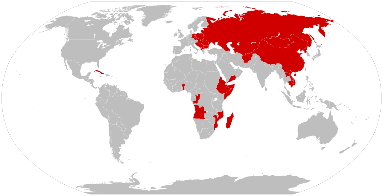
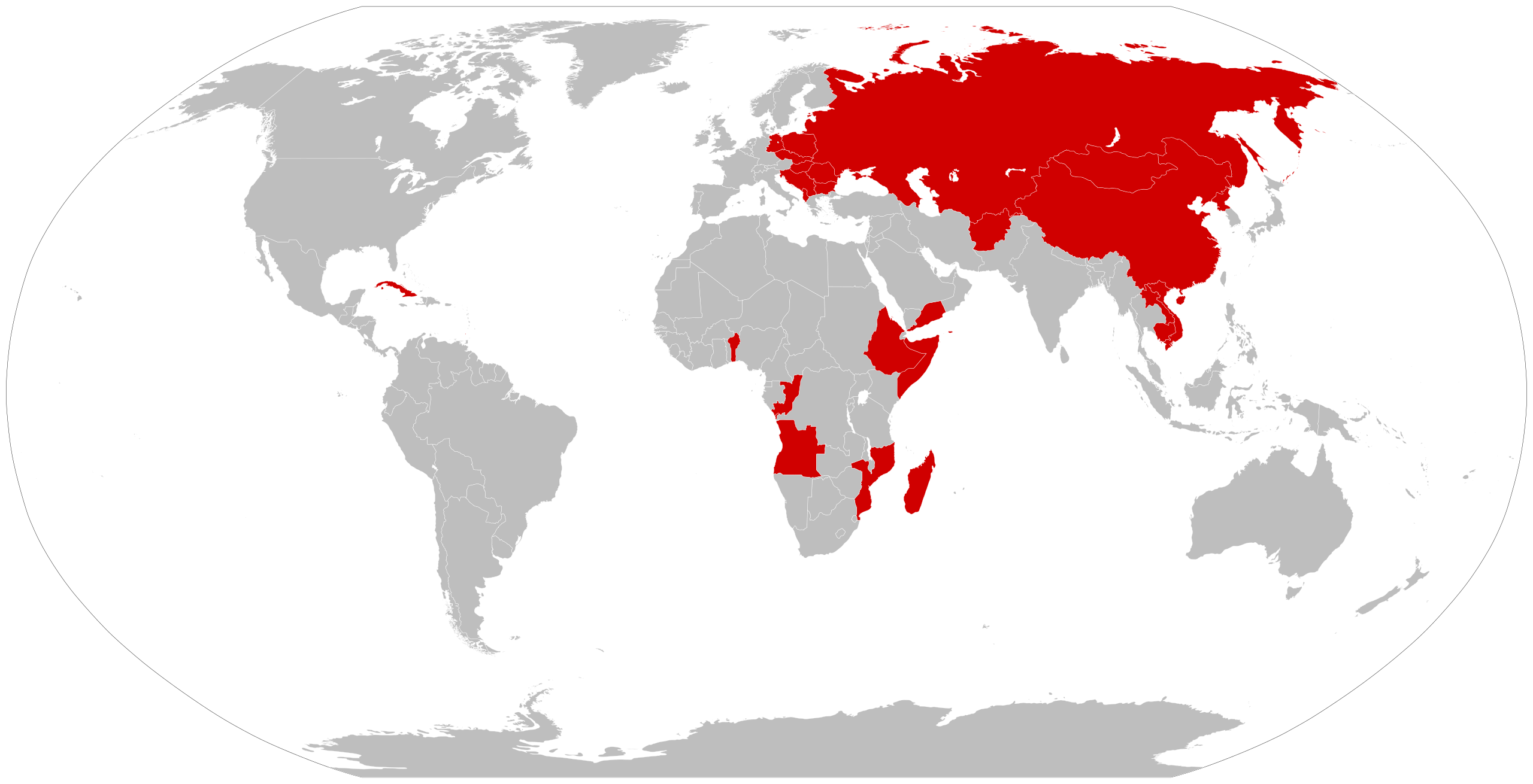
العربية: خريطة قديمة (باستخدام الحدود الحالية) تُظهر الدول التي حُكمت بالماركسية اللينينية ذات حزب واحد في مرحلة ما من تاريخها كانت جميع الأمم الملونة أعلاه تحت سيطرة الشيوعيين الماركسيين اللينينيين في نفس الوقت.
English: An anachronous map of countries (using present-day borders) that have been ruled by a one-party Marxist-Leninist state at some point in their history.
By the time of the 1979-1983 Communist Grenada, all the colored nations above were simultaneously Communist-controlled. |
| తేదీ | |
| మూలం | స్వంత కృతి |
| కర్త | Smurfy |
| ఇతర కూర్పులు |
Derivative works of this file: Communist countries.svg  |
| SVG పెరుగుదల | This vector image was created with Inkscape, or with something else. |
లైసెన్సింగ్
| నేను, ఈ కృతి యొక్క కాపీహక్కుదారుని, ఈ కృతిని సార్వజనీనం'గా విడుదల చేస్తున్నాను. ఇది ప్రపంచవ్యాప్తంగా వర్తిస్తుంది. కొన్ని దేశాల్లో ఇది చట్టబద్ధంగా సాధ్యంకాకపోవచ్చు; అయితే: ఈ కృతిని ఎటువంటి షరతులు లేకుండా, అట్టి షరతులు చట్టం వల్ల తప్పనిసరి అయితే తప్ప, ఏ ఉద్దేశానికైనా ఉపయోగించుకునే హక్కును ఎవరికైనా నేను ప్రదానం చేస్తున్నాను. |
ఫైలు చరితం
తేదీ/సమయం ను నొక్కి ఆ సమయాన ఫైలు ఎలా ఉండేదో చూడవచ్చు.
| తేదీ/సమయం | నఖచిత్రం | కొలతలు | వాడుకరి | వ్యాఖ్య | |
|---|---|---|---|---|---|
| ప్రస్తుత | 18:18, 13 ఏప్రిల్ 2024 | | 860 × 440 (1.18 MB) | Campista2015 | Reverted to version as of 13:08, 22 November 2017 (UTC) |
| 17:34, 20 డిసెంబరు 2017 |  | 860 × 440 (1.18 MB) | Jdx | Reverted to version as of 02:34, 22 October 2016 (UTC) | |
| 13:08, 22 నవంబరు 2017 |  | 860 × 440 (1.18 MB) | Ameet12345 | Reverted to version as of 12:55, 22 November 2017 (UTC) | |
| 13:06, 22 నవంబరు 2017 |  | 940 × 477 (1.55 MB) | Ameet12345 | Reverted to version as of 14:50, 18 July 2010 (UTC) | |
| 12:55, 22 నవంబరు 2017 |  | 860 × 440 (1.18 MB) | Ameet12345 | Reverted to version as of 22:37, 19 July 2010 (UTC) | |
| 02:34, 22 అక్టోబరు 2016 |  | 860 × 440 (1.18 MB) | TriadicRelation98 | Updated to add Madagascar and Grenada | |
| 20:24, 18 సెప్టెంబరు 2011 |  | 860 × 440 (1.18 MB) | Fry1989 | Reverted to version as of 22:37, 19 July 2010 | |
| 17:09, 18 సెప్టెంబరు 2011 | నఖచిత్రం లేదు | 0 × 0 (15.41 MB) | JJ Georges | added Madagascar (included to the list by several scholars) and Grenada | |
| 22:37, 19 జూలై 2010 |  | 860 × 440 (1.18 MB) | Beao | Removed border. | |
| 14:50, 18 జూలై 2010 |  | 940 × 477 (1.55 MB) | Smurfy | {{Information |Description=An anachronous map of countries (using present-day borders) that have been ruled by a one-party Marxist-Leninist state at some point in their history. By the time of the 1979-1983 [ |
లింకులు
కింది పేజీలలో ఈ ఫైలుకు లింకులు ఉన్నాయి:
సార్వత్రిక ఫైలు వాడుక
ఈ దస్త్రాన్ని ఈ క్రింది ఇతర వికీలు ఉపయోగిస్తున్నాయి:
- am.wikipedia.org లో వాడుక
- ar.wikipedia.org లో వాడుక
- bh.wikipedia.org లో వాడుక
- ca.wikipedia.org లో వాడుక
- ckb.wikipedia.org లో వాడుక
- cs.wikipedia.org లో వాడుక
- de.wikipedia.org లో వాడుక
- en.wikipedia.org లో వాడుక
- eo.wikipedia.org లో వాడుక
- it.wikipedia.org లో వాడుక
- ko.wikipedia.org లో వాడుక
- mr.wikipedia.org లో వాడుక
- oc.wikipedia.org లో వాడుక
- simple.wikipedia.org లో వాడుక
- sq.wikipedia.org లో వాడుక
- sr.wikipedia.org లో వాడుక
- th.wikipedia.org లో వాడుక
- uk.wikipedia.org లో వాడుక
- vi.wikipedia.org లో వాడుక
- zh-yue.wikipedia.org లో వాడుక
- zh.wikipedia.org లో వాడుక