దస్త్రం:Dardanelles landsat.jpg
Jump to navigation
Jump to search
మరింత స్పష్టమైన బొమ్మ లేదు.
Dardanelles_landsat.jpg (737 × 584 పిక్సెళ్ళు, ఫైలు పరిమాణం: 593 KB, MIME రకం: image/jpeg)
This is a file from the Wikimedia Commons. Information from its description page there is shown below. Commons is a freely licensed media file repository. You can help. |
సారాంశం
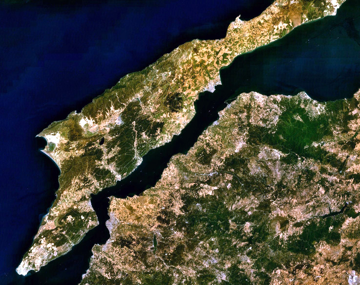
| వివరణ |
English: Landsat 7 image of the Dardanelles and Gallipoli Peninsula, Turkey. |
|||
| తేదీ | ||||
| మూలం | Captured and cropped from NASA World Wind. | |||
| కర్త | NASA | |||
| అనుమతి (ఈ దస్త్రాన్ని పునర్వినియోగించుకోవడం) |
|

ఫైలు చరితం
తేదీ/సమయం ను నొక్కి ఆ సమయాన ఫైలు ఎలా ఉండేదో చూడవచ్చు.
| తేదీ/సమయం | నఖచిత్రం | కొలతలు | వాడుకరి | వ్యాఖ్య | |
|---|---|---|---|---|---|
| ప్రస్తుత | 03:06, 26 సెప్టెంబరు 2013 | | 737 × 584 (593 KB) | Jahoe | improved colour |
| 12:53, 17 సెప్టెంబరు 2006 |  | 737 × 584 (205 KB) | ChrisO | NASA Landsat 7 image of the Dardanelles and Gallipoli Peninsula, Turkey. Category:Satellite images of peninsulas |
లింకులు
కింది పేజీలలో ఈ ఫైలుకు లింకులు ఉన్నాయి:
సార్వత్రిక ఫైలు వాడుక
ఈ దస్త్రాన్ని ఈ క్రింది ఇతర వికీలు ఉపయోగిస్తున్నాయి:
- af.wikipedia.org లో వాడుక
- an.wikipedia.org లో వాడుక
- ar.wikipedia.org లో వాడుక
- arz.wikipedia.org లో వాడుక
- ast.wikipedia.org లో వాడుక
- azb.wikipedia.org లో వాడుక
- be-tarask.wikipedia.org లో వాడుక
- be.wikipedia.org లో వాడుక
- bg.wikipedia.org లో వాడుక
- bo.wikipedia.org లో వాడుక
- ca.wikipedia.org లో వాడుక
- ceb.wikipedia.org లో వాడుక
- ckb.wikipedia.org లో వాడుక
- co.wikipedia.org లో వాడుక
- cs.wikipedia.org లో వాడుక
- cy.wikipedia.org లో వాడుక
- de.wikipedia.org లో వాడుక
- el.wikipedia.org లో వాడుక
- en.wikipedia.org లో వాడుక
- eo.wikipedia.org లో వాడుక
- eo.wikiquote.org లో వాడుక
- es.wikipedia.org లో వాడుక
- eu.wikipedia.org లో వాడుక
- fa.wikipedia.org లో వాడుక
- fr.wikipedia.org లో వాడుక
- ga.wikipedia.org లో వాడుక
- gl.wikipedia.org లో వాడుక
- he.wikipedia.org లో వాడుక
- ja.wikipedia.org లో వాడుక
- kk.wikipedia.org లో వాడుక
- ku.wikipedia.org లో వాడుక
- ky.wikipedia.org లో వాడుక
- lb.wikipedia.org లో వాడుక
- nn.wikipedia.org లో వాడుక
- no.wikipedia.org లో వాడుక
- pl.wikipedia.org లో వాడుక
ఈ దస్త్రపు మరింత సార్వత్రిక వాడుకను చూడండి.