దస్త్రం:Desert Lop Nur 89.00E, 40.30N between Kuruktagh and Astintagh.jpg
Jump to navigation
Jump to search
ఈ మునుజూపు పరిమాణం: 603 × 599 పిక్సెళ్ళు. ఇతర రిజల్యూషన్లు: 241 × 240 పిక్సెళ్ళు | 483 × 480 పిక్సెళ్ళు | 773 × 768 పిక్సెళ్ళు | 1,187 × 1,180 పిక్సెళ్ళు.
అసలు దస్త్రం (1,187 × 1,180 పిక్సెళ్ళు, ఫైలు పరిమాణం: 1.56 MB, MIME రకం: image/jpeg)
This is a file from the Wikimedia Commons. Information from its description page there is shown below. Commons is a freely licensed media file repository. You can help. |
సారాంశం
| వివరణ |
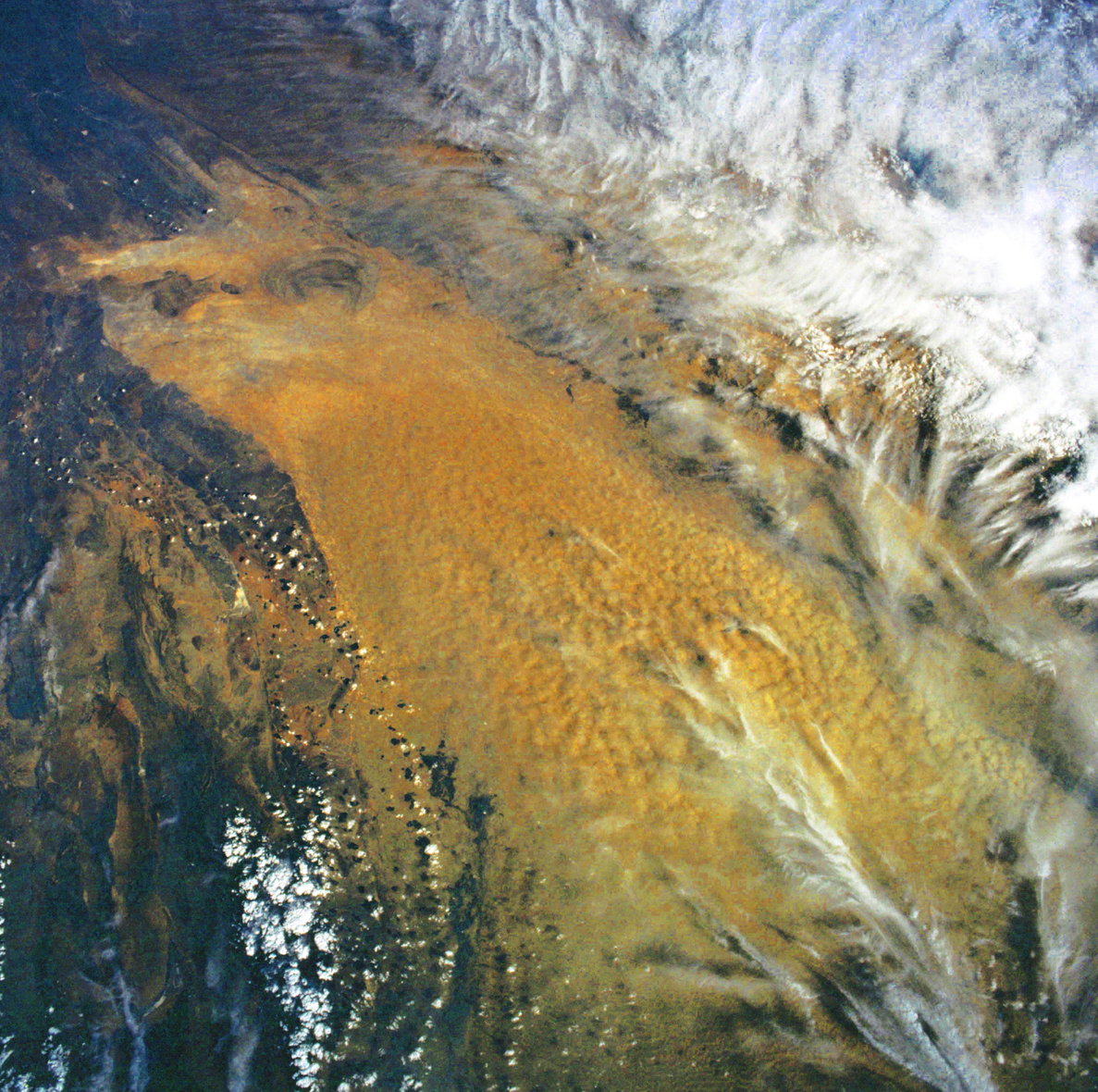
English: China, Xinjiang, desert Lop Nur. Satellite picture of the Desert of Lop with the Basin of the formerly sea Lop Nur. In the left Kuruktagh, in the right Astintagh.
Deutsch: China, Xinjiang, Wüste Lop Nor. Satellitenaufnahme von der Wüste Lop Nor mit dem Seebecken Lop Nor im Hintergrund. Links sieht man das Gebirge Kuruktagh, rechts die tibetische Hochebene des Astintagh. Blick von Westen Richtung Osten. |
| తేదీ | |
| మూలం |
NASA Mission: STS106, Roll-Frame 719 – 6, File name STS106-719-6_3.JPG, Mission ID on the Film or image: STS106, from ISD PhotoCDs. [1]. |
| కర్త | NASA. Image Science and Analysis Laboratory, NASA-Johnson Space Center. 25 Mar. 2005. "Astronaut Photography of Earth - Display Record." Color adjusting of this image (using Adobe Photoshop 6.0): Michael Gaebler, March 11, 2006, own work, all rights released (Public domain). de: Zugrunde liegt ein noch nicht farbrichtiges Astronauten-Foto der NASA. Diese Fotografie wurde von Michael Gaebler am 11. März 2006 im RGB-Modus mit Adobe Photoshop 6.0 mit Farb- und Tonwertkorrekturen überarbeitet. |
| అనుమతి (ఈ దస్త్రాన్ని పునర్వినియోగించుకోవడం) |
PD-USGov-NASA |
This image or video was catalogued by one of the centers of the United States National Aeronautics and Space Administration (NASA) under Photo ID: STS106-719-6. This tag does not indicate the copyright status of the attached work. A normal copyright tag is still required. See Commons:Licensing. Other languages:
|
లైసెన్సింగ్
| This file is in the public domain in the United States because it was solely created by NASA. NASA copyright policy states that "NASA material is not protected by copyright unless noted". (See Template:PD-USGov, NASA copyright policy page or JPL Image Use Policy.) | ||
 |
Warnings:
|
ఫైలు చరితం
తేదీ/సమయం ను నొక్కి ఆ సమయాన ఫైలు ఎలా ఉండేదో చూడవచ్చు.
| తేదీ/సమయం | నఖచిత్రం | కొలతలు | వాడుకరి | వ్యాఖ్య | |
|---|---|---|---|---|---|
| ప్రస్తుత | 15:37, 6 సెప్టెంబరు 2008 | | 1,187 × 1,180 (1.56 MB) | Michael Gäbler | {{Information |Description= |Source= |Date= |Author= |Permission= |other_versions= }} |
| 21:47, 11 మార్చి 2006 |  | 1,209 × 1,200 (1.54 MB) | Michael Gäbler | == Summary == {{Information| |Description = en: China, Xinjiang, desert Lop Nur. Satellite picture of the Desert of Lop with the Basin of the formerly sea Lop Nur. In the left Kuruktagh, in the right Astintagh. de: China, Xinjiang, Wüste Lop Nor. S |
లింకులు
కింది పేజీలలో ఈ ఫైలుకు లింకులు ఉన్నాయి:
సార్వత్రిక ఫైలు వాడుక
ఈ దస్త్రాన్ని ఈ క్రింది ఇతర వికీలు ఉపయోగిస్తున్నాయి:
- ar.wikipedia.org లో వాడుక
- arz.wikipedia.org లో వాడుక
- az.wikipedia.org లో వాడుక
- br.wikipedia.org లో వాడుక
- de.wikipedia.org లో వాడుక
- en.wikipedia.org లో వాడుక
- es.wikipedia.org లో వాడుక
- eu.wikipedia.org లో వాడుక
- fa.wikipedia.org లో వాడుక
- frr.wikipedia.org లో వాడుక
- fr.wikipedia.org లో వాడుక
- he.wikivoyage.org లో వాడుక
- hu.wikipedia.org లో వాడుక
- id.wikipedia.org లో వాడుక
- la.wikipedia.org లో వాడుక
- lt.wikipedia.org లో వాడుక
- lv.wikipedia.org లో వాడుక
- mk.wikipedia.org లో వాడుక
- ml.wikipedia.org లో వాడుక
- pt.wikipedia.org లో వాడుక
- ro.wikipedia.org లో వాడుక
- ru.wikipedia.org లో వాడుక
- sl.wikipedia.org లో వాడుక
- tr.wikipedia.org లో వాడుక
- uk.wikipedia.org లో వాడుక
- www.wikidata.org లో వాడుక