దస్త్రం:Earth's water distribution.svg

అసలు దస్త్రం (SVG ఫైలు, నామమాత్రంగా 430 × 350 పిక్సెళ్ళు, ఫైలు పరిమాణం: 31 KB)
This is a file from the Wikimedia Commons. Information from its description page there is shown below. Commons is a freely licensed media file repository. You can help. |
సారాంశం
This file is translated using SVG <switch> elements. All translations are stored in the same file! Learn more.
For most Wikipedia projects, you can embed the file normally (without a To translate the text into your language, you can use the SVG Translate tool. Alternatively, you can download the file to your computer, add your translations using whatever software you're familiar with, and re-upload it with the same name. You will find help in Graphics Lab if you're not sure how to do this. |
| వివరణ |
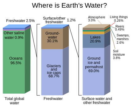
English: Graph of the locations of water on Earth |
| మూలం | https://water.usgs.gov/edu/gallery/watercyclekids/earth-water-distribution.html - traced and redrawn from File:Earth's water distribution.gif |
| కర్త | USGS |
| ఇతర కూర్పులు | Earth's water distribution-gl.svg |
| SVG పెరుగుదల | This vector image was created with Inkscape. |
లైసెన్సింగ్
This image is in the public domain in the United States because it only contains materials that originally came from the United States Geological Survey, an agency of the United States Department of the Interior. For more information, see the official USGS copyright policy.
|
ఫైలు చరితం
తేదీ/సమయం ను నొక్కి ఆ సమయాన ఫైలు ఎలా ఉండేదో చూడవచ్చు.
| తేదీ/సమయం | నఖచిత్రం | కొలతలు | వాడుకరి | వ్యాఖ్య | |
|---|---|---|---|---|---|
| ప్రస్తుత | 22:28, 31 జనవరి 2024 | | 430 × 350 (31 KB) | Asierog | spanish and french translations added |
| 12:32, 22 నవంబరు 2016 |  | 430 × 350 (25 KB) | MaxxL | updated | |
| 14:00, 22 మే 2010 |  | 530 × 368 (202 KB) | Begoon | {{Information |Description={{en|1=Graph of the locations of water on Earth}} |Source=http://ga.water.usgs.gov/edu/waterdistribution.html |Author=USGS |Date= |Permission= |other_versions= }} |
లింకులు
కింది పేజీలలో ఈ ఫైలుకు లింకులు ఉన్నాయి:
సార్వత్రిక ఫైలు వాడుక
ఈ దస్త్రాన్ని ఈ క్రింది ఇతర వికీలు ఉపయోగిస్తున్నాయి:
- el.wikipedia.org లో వాడుక
- en.wikipedia.org లో వాడుక
- en.wikibooks.org లో వాడుక
- en.wikiversity.org లో వాడుక
- es.wikipedia.org లో వాడుక
- et.wikipedia.org లో వాడుక
- eu.wikipedia.org లో వాడుక
- fr.wikipedia.org లో వాడుక
- gu.wikipedia.org లో వాడుక
- hi.wikipedia.org లో వాడుక
- hy.wikipedia.org లో వాడుక
- ka.wikipedia.org లో వాడుక
- ms.wikipedia.org లో వాడుక
- si.wikipedia.org లో వాడుక
- tr.wikipedia.org లో వాడుక
- vi.wikipedia.org లో వాడుక
- zh.wikipedia.org లో వాడుక