దస్త్రం:Goa locator map.svg
Jump to navigation
Jump to search

ఈ ఫైలు SVG కు చెందిన ఈ మునుజూపు PNG పరిమాణం: 274 × 331 పిక్సెళ్ళు. ఇతర రిజల్యూషన్లు: 199 × 240 పిక్సెళ్ళు | 397 × 480 పిక్సెళ్ళు | 636 × 768 పిక్సెళ్ళు | 848 × 1,024 పిక్సెళ్ళు | 1,695 × 2,048 పిక్సెళ్ళు.
అసలు దస్త్రం (SVG ఫైలు, నామమాత్రంగా 274 × 331 పిక్సెళ్ళు, ఫైలు పరిమాణం: 93 KB)
This is a file from the Wikimedia Commons. Information from its description page there is shown below. Commons is a freely licensed media file repository. You can help. |
| శీర్షిక |
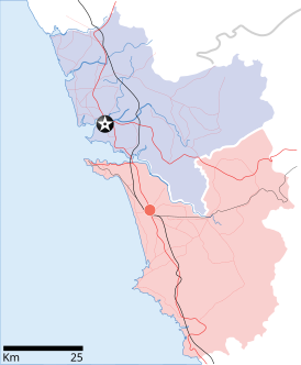
Goa locator map |
| Description |
Locator map for the state of w:Goa. Coordinates: top=15.811, bottom=14.861, left=73.567, right=74.287. |
| తేదీ | |
| మూలం |
స్వంత కృతి |
| స్రష్ట | |
| అనుమతి (ఈ దస్త్రాన్ని పునర్వినియోగించుకోవడం) |
నేను, ఈ కృతి యొక్క కాపీహక్కుదారుని, దీన్ని ఈ లైసెన్సు క్రింద ఇందుమూలముగా ప్రచురిస్తున్నాను: ఈ దస్త్రం క్రియేటివ్ కామన్స్ Attribution-Share Alike 3.0 Unported లైసెన్సు క్రింద లభ్యం.
|
| Geotemporal data | |
| Date depicted | second half of 20 century, 21 century |
| Georeferencing | If inappropriate please set warp_status = skip to hide. |
| Archival data | |
| గమనికలు | Part of WikiProject India Maps |
ఫైలు చరితం
తేదీ/సమయం ను నొక్కి ఆ సమయాన ఫైలు ఎలా ఉండేదో చూడవచ్చు.
| తేదీ/సమయం | నఖచిత్రం | కొలతలు | వాడుకరి | వ్యాఖ్య | |
|---|---|---|---|---|---|
| ప్రస్తుత | 10:48, 26 ఏప్రిల్ 2007 | | 274 × 331 (93 KB) | Planemad | upd |
| 10:40, 26 ఏప్రిల్ 2007 |  | 274 × 331 (80 KB) | Planemad | upd | |
| 18:27, 9 ఏప్రిల్ 2007 |  | 274 × 331 (66 KB) | Planemad | {{WikiProject_India_Maps |Title=Goa locator map |Description=Locator map for the state of [w:Goa]] |Source= [http://www.bombayproperty.com/goamap.jpg Map of Goa], |Date=April 2007 |Author=w:user:Planemad }} Category:WikiProject India State Maps |
లింకులు
కింది పేజీలలో ఈ ఫైలుకు లింకులు ఉన్నాయి:
సార్వత్రిక ఫైలు వాడుక
ఈ దస్త్రాన్ని ఈ క్రింది ఇతర వికీలు ఉపయోగిస్తున్నాయి:
- ar.wikipedia.org లో వాడుక
- ba.wikipedia.org లో వాడుక
- ceb.wikipedia.org లో వాడుక
- cy.wikipedia.org లో వాడుక
- de.wikipedia.org లో వాడుక
- en.wikipedia.org లో వాడుక
- Farmagudi
- Zuari River
- Pilar, Goa
- Bardez
- Sonsogor
- Flora and fauna of Goa
- Sanguem
- Mollem, Goa
- Dabolim
- Template:Goa-geo-stub
- Aquem
- Bambolim
- Bandora, Goa
- Canacona
- Karapur
- Chicalim
- Chimbel
- Colvale
- Curti, Goa
- Davorlim
- Parcem
- Penha de França, Goa
- Queula
- Sancoale
- Sanquelim
- Sanvordem
- São José de Areal
- Valpoi
- Arpora
- Altinho, Goa
- Mardol, Goa
- Gokarna Math
- Baga, Goa
- Baga Creek
- Chapora Beach
- Terekhol River
- Kasarpal
- Revora
- Pale, Goa
- Agaçaim
- Priol
- Betul, Goa
- Bogmalo
- Adas Bank
- St Inez Creek
ఈ దస్త్రపు మరింత సార్వత్రిక వాడుకను చూడండి.