దస్త్రం:Hungary 1941-44 Administrative Map.png
Jump to navigation
Jump to search
ఈ మునుజూపు పరిమాణం: 800 × 431 పిక్సెళ్ళు. ఇతర రిజల్యూషన్లు: 320 × 173 పిక్సెళ్ళు | 640 × 345 పిక్సెళ్ళు | 1,024 × 552 పిక్సెళ్ళు | 1,280 × 690 పిక్సెళ్ళు | 2,560 × 1,380 పిక్సెళ్ళు | 4,000 × 2,157 పిక్సెళ్ళు.
అసలు దస్త్రం (4,000 × 2,157 పిక్సెళ్ళు, ఫైలు పరిమాణం: 2.55 MB, MIME రకం: image/png)
This is a file from the Wikimedia Commons. Information from its description page there is shown below. Commons is a freely licensed media file repository. You can help. |

|
This map image could be re-created using vector graphics as an SVG file. This has several advantages; see Commons:Media for cleanup for more information. If an SVG form of this image is available, please upload it and afterwards replace this template with
{{vector version available|new image name}}.
It is recommended to name the SVG file “Hungary 1941-44 Administrative Map.svg”—then the template Vector version available (or Vva) does not need the new image name parameter. |
సారాంశం
| వివరణ |
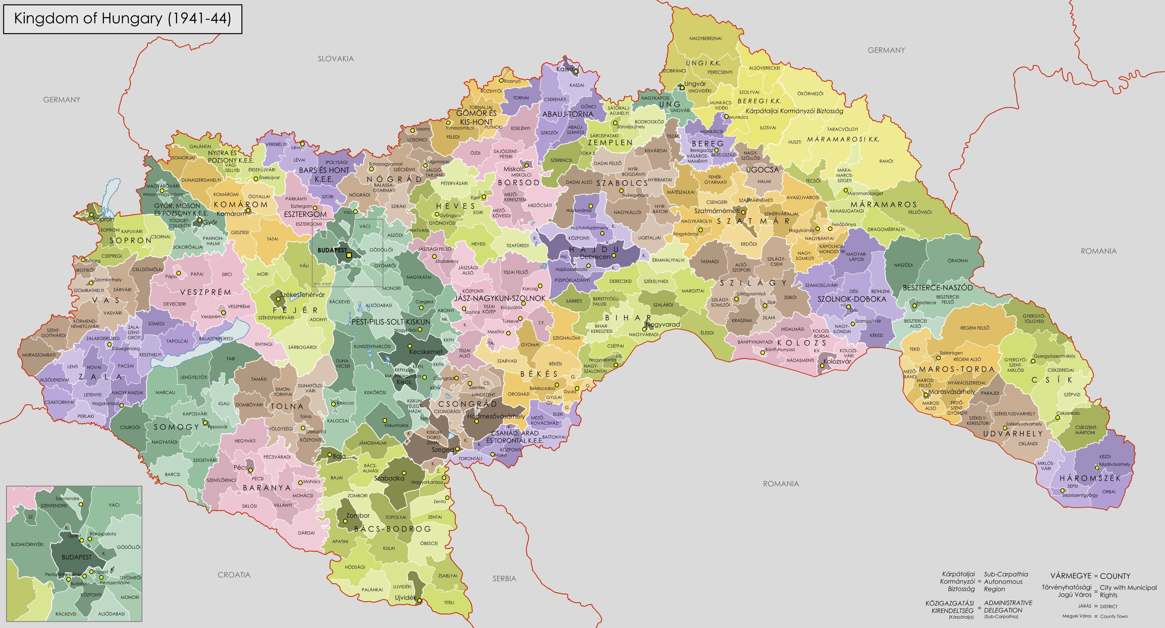
English: Administrative Map of the Kingdom of Hungary from 1941-44. |
| తేదీ | |
| మూలం |
Own work using:
|
| కర్త | XrysD |
లైసెన్సింగ్
నేను, ఈ కృతి యొక్క కాపీహక్కుదారుని, దీన్ని ఇందుమూలముగా ఈ లైసెన్సుల క్రింద ప్రచురిస్తున్నాను:

|
ఈ కృతి యొక్క కర్తనైన నేను, ఇక నుండీ ఈ కృతిని కాపీ చేసుకోవడానికి, పంచి పెట్టడానికి మరియు/లేదా మార్పులు-చేర్పులు చేసుకోవడానికి GFDL, లైసెన్సు వెర్షను 1.2 లేదా దాని తరువాత స్వేచ్చా సాఫ్టువేరు ఫౌండేషను విడుదలచేసే ఏ GFDL లైసెన్సు ద్వారా నయినా అనుమతి ఇస్తున్నాను; ఈ కృతిలో మార్చకూడని బాగాలు లేవు, Front-Cover పాఠం లేదు, Back-Cover పాఠం లేదు. ఈ లైసెన్సు యొక్క పత్రం నకలును "జిఎన్యూ ఉచిత డాక్యుమెంటేషను లైసెన్సు" అని పిలుస్తున్న విభాగంలో ఉంది. |
| ఈ దస్త్రం క్రియేటివ్ కామన్స్ Attribution-Share Alike 3.0 Unported లైసెన్సు క్రింద లభ్యం. | ||
| ||
| GFDL లైసెన్సు తాజాకరణలో భాగంగా ఈ దస్త్రానికి ఈ లైసెన్సింగు ట్యాగుని చేర్చారు. |
పైవాటిలో మీకు నచ్చిన లైసెన్సునును ఎంచుకోవచ్చు.
ఫైలు చరితం
తేదీ/సమయం ను నొక్కి ఆ సమయాన ఫైలు ఎలా ఉండేదో చూడవచ్చు.
| తేదీ/సమయం | నఖచిత్రం | కొలతలు | వాడుకరి | వ్యాఖ్య | |
|---|---|---|---|---|---|
| ప్రస్తుత | 18:04, 25 ఆగస్టు 2016 | | 4,000 × 2,157 (2.55 MB) | XrysD | Fixed typo for Hajduböszörmeny (thanks Tunde). |
| 12:40, 11 ఏప్రిల్ 2009 |  | 4,000 × 2,157 (2.58 MB) | XrysD | Borders edited to be more accurate and spelling mistakes corrected | |
| 21:15, 18 జనవరి 2009 |  | 4,000 × 2,215 (2.47 MB) | XrysD | {{Information |Description= |Source= |Date= |Author= |Permission= |other_versions= }} | |
| 20:50, 18 జనవరి 2009 |  | 4,940 × 2,736 (3.18 MB) | XrysD | {{Information |Description={{en|1=Administrative Map of the Kingdom of Hungary from 1941-44.}} |Source=Own work by uploader |Author=XrysD |Date=18/01/2009 |Permission= |other_versions= }} <!--{{ImageUpload|full}}--> |
లింకులు
కింది పేజీలలో ఈ ఫైలుకు లింకులు ఉన్నాయి:
సార్వత్రిక ఫైలు వాడుక
ఈ దస్త్రాన్ని ఈ క్రింది ఇతర వికీలు ఉపయోగిస్తున్నాయి:
- azb.wikipedia.org లో వాడుక
- bn.wikipedia.org లో వాడుక
- cy.wikipedia.org లో వాడుక
- de.wikipedia.org లో వాడుక
- en.wikipedia.org లో వాడుక
- eu.wikipedia.org లో వాడుక
- fr.wikipedia.org లో వాడుక
- hu.wikipedia.org లో వాడుక
- hy.wikipedia.org లో వాడుక
- id.wikipedia.org లో వాడుక
- it.wikipedia.org లో వాడుక
- ja.wikipedia.org లో వాడుక
- mk.wikipedia.org లో వాడుక
- nl.wikipedia.org లో వాడుక
- pl.wikipedia.org లో వాడుక
- pt.wikipedia.org లో వాడుక
- ro.wikipedia.org లో వాడుక
- ru.wikipedia.org లో వాడుక
- sh.wikipedia.org లో వాడుక
- sl.wikipedia.org లో వాడుక
- sr.wikipedia.org లో వాడుక
- th.wikipedia.org లో వాడుక
- uk.wikipedia.org లో వాడుక
- zh.wikipedia.org లో వాడుక