దస్త్రం:India Karnataka location map.svg
Jump to navigation
Jump to search

ఈ ఫైలు SVG కు చెందిన ఈ మునుజూపు PNG పరిమాణం: 423 × 600 పిక్సెళ్ళు. ఇతర రిజల్యూషన్లు: 169 × 240 పిక్సెళ్ళు | 338 × 480 పిక్సెళ్ళు | 542 × 768 పిక్సెళ్ళు | 722 × 1,024 పిక్సెళ్ళు | 1,445 × 2,048 పిక్సెళ్ళు | 898 × 1,273 పిక్సెళ్ళు.
అసలు దస్త్రం (SVG ఫైలు, నామమాత్రంగా 898 × 1,273 పిక్సెళ్ళు, ఫైలు పరిమాణం: 759 KB)
This is a file from the Wikimedia Commons. Information from its description page there is shown below. Commons is a freely licensed media file repository. You can help. |
| వివరణ |
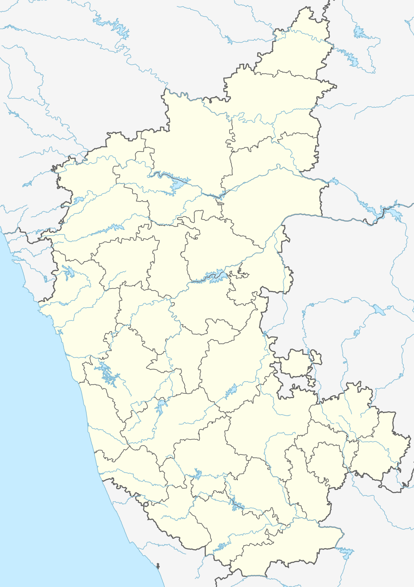
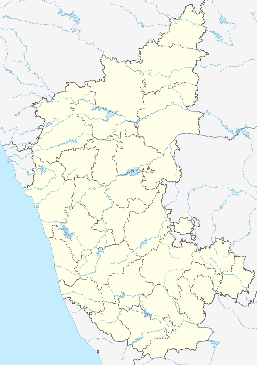
Location map of Karnataka Geographic limits of the map:
|
| తేదీ | (UTC) |
| మూలం | |
| కర్త |
|
| ఇతర కూర్పులు |
Derivative works of this file: |
| This is a retouched picture, which means that it has been digitally altered from its original version. Modifications: Created 3 new districts Chikkaballapur, Ramanagara and Yadgir. Changed conventions per WP:WPMAP. The original can be viewed here: Karnataka locator map.svg:
|
ఈ దస్త్రం క్రియేటివ్ కామన్స్ Attribution-Share Alike 3.0 Unported లైసెన్సు క్రింద లభ్యం.
- ఇలా చేసేందుకు మీకు స్వేచ్ఛ ఉంది:
- పంచుకోడానికి – ఈ కృతిని కాపీ చేసుకోవచ్చు, పంపిణీ చేయవచ్చు, ప్రసారమూ చేయవచ్చు
- రీమిక్స్ చేయడానికి – కృతిని అనుకరించడానికి
- క్రింది షరతులకు లోబడి:
- ఆపాదింపు – సముచితమైన శ్రేయస్సును ఇవ్వాలి, లైసెన్సుకు లింకు ఇవ్వాలి, మార్పులేమైనా చేస్తే వాటిని సూచించాలి. అందుకు సముచితమైన పద్ధతి దేన్నైనా అవలంబించవచ్చు. కానీ మీకూ మీ వాడుకకూ హక్కుదారు అనుమతించారు అనే అర్థం వచ్చేటట్లుగా మాత్రం కాదు.
- share alike – మీరు ఈ కృతిని అనుకరిస్తే, మారిస్తే, లేదా మెరుగుపరిస్తే తత్ఫలిత కృతిని ఇదే లైసెన్సు లేదా దీనికి అనుగుణ్యమైన లైసెన్సు క్రింద మాత్రమే పంపిణీ చేయాలి.
అసలు ఎక్కింపుల చిట్టా
This image is a derivative work of the following images:
- File:Karnataka_locator_map.svg licensed with Cc-by-sa-3.0
- 2007-05-06T13:55:02Z Planemad 1630x2356 (231773 Bytes) {{WikiProject_India_Maps |Title=Karnataka locator Map |Description=Map of [[w:Karnataka]] with road and rail lines |Source= [http://aquarium.lipetsk.ru/discovery/India2004/karnataka-map.jpg Karnataka Map], [http://www.indianr
Uploaded with derivativeFX
ఫైలు చరితం
తేదీ/సమయం ను నొక్కి ఆ సమయాన ఫైలు ఎలా ఉండేదో చూడవచ్చు.
| తేదీ/సమయం | నఖచిత్రం | కొలతలు | వాడుకరి | వ్యాఖ్య | |
|---|---|---|---|---|---|
| ప్రస్తుత | 03:10, 16 జూన్ 2023 | | 898 × 1,273 (759 KB) | C1MM | c Vijayanagara district |
| 04:41, 13 ఆగస్టు 2021 |  | 851 × 1,211 (582 KB) | C1MM | Added more rivers | |
| 03:33, 16 జూలై 2021 |  | 851 × 1,211 (561 KB) | C1MM | Added more accurate district boundaries | |
| 23:41, 14 డిసెంబరు 2020 |  | 1,634 × 2,367 (341 KB) | C1MM | Fixed boundaries of Vijayanagara district | |
| 22:10, 14 డిసెంబరు 2020 |  | 1,634 × 2,367 (345 KB) | C1MM | Added boundaries of AP/Telangana and rivers | |
| 19:26, 13 డిసెంబరు 2020 |  | 1,634 × 2,367 (342 KB) | C1MM | Fixed district boundaries of Ballari and added Vijayanagara district | |
| 03:53, 21 ఏప్రిల్ 2020 |  | 1,634 × 2,367 (289 KB) | C1MM | Added rivers | |
| 15:50, 15 నవంబరు 2010 |  | 1,630 × 2,356 (207 KB) | Nayvik | Changed background color | |
| 15:34, 15 నవంబరు 2010 |  | 1,630 × 2,356 (206 KB) | Nayvik | {{Information |Description=Location map of Karnataka Geographic limits of the map: * 18.5°N * 11.0°N * 73.6°E * 78.7°E |Source=*File:Karnataka_locator_map.svg, [http://www.censusindia.gov.in/2011-Images/ADMINI2011.jpg Census In |
లింకులు
కింది పేజీలలో ఈ ఫైలుకు లింకులు ఉన్నాయి:
- 55 మల్లపుర
- అచనుర్
- అడగల్
- అనేకెరె
- అన్నపూర్ణ దేవాలయం (హొరనాడు, కర్ణాటక)
- అన్నిగెరి (కర్ణాటక)
- అల్సూర్ సరస్సు
- అస్నోటి రైల్వే స్టేషను
- ఆగసనుర్
- ఉడిపి
- ఉడిపి శ్రీ కృష్ణ మఠం
- కరంజి సరస్సు
- కల్లేశ్వర దేవాలయం (కర్ణాటక)
- కార్వార్
- కాళీ పులుల సంరక్షణ కేంద్రం
- కుందాద్రి
- కుక్కరహళ్ళి సరస్సు
- కుక్కే సుబ్రహ్మణ్య దేవాలయం
- కొప్పల్
- కొల్లూరు మూకాంబిక దేవాలయం
- కోటిలింగేశ్వర దేవాలయం
- కోలార్
- గదగ్
- గుడ్డట్టు వినాయక దేవాలయం
- గుల్బర్గా
- గోమటేశ్వర విగ్రహం
- గోల్ గుంబద్
- చిక్కబళ్లాపూర్
- చిక్కమగళూరు
- చిత్రదుర్గ
- చిత్రాపూర్ రైల్వే స్టేషను
- చెన్నకేశవ దేవాలయం (బేలూరు)
- జలిహాల్
- తోకూర్ రైల్వే స్టేషను
- దాండేలి
- ద్విభుజ గణపతి స్వామి ఆలయం
- ధార్వాడ్ (కర్ణాటక)
- నంది హిల్స్
- నందికూర్ రైల్వే స్టేషను
- నవగ్రహ జైన దేవాలయం
- పంపా సరోవర్
- పడుబిద్రి రైల్వే స్టేషను
- పలిమారు
- పావగడ
- పేజావర
- బంద్రి
- బనవాసి (కర్ణాటక)
- బన్నేర్ఘట్ట జాతీయ ఉద్యానవనం
- బసవకల్యాణ్
- బీజాపూర్ (కర్ణాటక)
- బీదర్
- బీదర్ కోట
- బెల్గాం
- భత్కళ్ రైల్వే స్టేషను
- మంకి రైల్వే స్టేషను
- మంజునాథ ఆలయం
- మడివాలా సరస్సు
- మత్తూరు
- మరవంతే
- మాండ్య
- యలహంక సరస్సు
- యాద్గిర్
- రామనగర
- రాయచూర్
- లోటస్ మహల్
- వర్తూర్ సరస్సు
- విరూపాక్ష దేవాలయం, హంపి
- వేణుగోపాల స్వామి దేవాలయం (మైసూరు)
- శాంతి సాగర
- శివమొగ్గ
- శ్రీరంగపట్టణం
- సకలేష్పూర్
- సదాశివ దేవాలయం (కర్ణాటక)
- సిర్సి మారికాంబా దేవాలయం
- హంపి (పట్టణం)
- హవేరి
- హసన్ (కర్ణాటక)
- హాన్నమ సరస్సు
- హోస్పేట్
- మూస:Location map India Karnataka
- మూస:Location map Karnataka
- మాడ్యూల్:Location map/data/India Karnataka
- మాడ్యూల్:Location map/data/India Karnataka/doc
సార్వత్రిక ఫైలు వాడుక
ఈ దస్త్రాన్ని ఈ క్రింది ఇతర వికీలు ఉపయోగిస్తున్నాయి:
- ar.wikipedia.org లో వాడుక
- as.wikipedia.org లో వాడుక
- azb.wikipedia.org లో వాడుక
- تومکور
- بنقلور
- عباسی، کارناتاکا
- اودقولام
- پیکلیهال
- اوداجی (هیندوستان)
- اوچیلا, اودوپی دیستریکت
- اوچاواد
- او خاناپور
- ویراهانوماکاناپالیا
- فاجیر (هیندوستان)
- پتالور (هیندوستان)
- پت آماپور
- ویراکامبا
- ویراپور
- وانور (هیندوستان)
- ساتیجری
- ساتانور, ماقادی
- ساتانور, بانقالور
- ساسالاتی
- سارقور
- ساراواد
- ساراپادی
- ساپتاساقار
- سانتور
- سانتکاسالاجر
- مایاکوندا
- ساناتی
- ماویناکر
- ماوالی
- ماتیواد
- کالادکا
- سانیکاتا
- کالکونت
- کالکری
- ماتماری
- سانقاناهالا
- کالجی (هیندوستان)
- سانقامشوارا, کالاقاتاجی
- ماتاداکوروباراهاتی
- ماستیهولی
- کالاسا, کوندقول
- ماسارکال
- ماسابینال
ఈ దస్త్రపు మరింత సార్వత్రిక వాడుకను చూడండి.