దస్త్రం:Kansas City Kansas aerial view.jpg
Jump to navigation
Jump to search

ఈ మునుజూపు పరిమాణం: 800 × 534 పిక్సెళ్ళు. ఇతర రిజల్యూషన్లు: 320 × 214 పిక్సెళ్ళు | 640 × 427 పిక్సెళ్ళు | 1,024 × 683 పిక్సెళ్ళు | 1,500 × 1,001 పిక్సెళ్ళు.
అసలు దస్త్రం (1,500 × 1,001 పిక్సెళ్ళు, ఫైలు పరిమాణం: 579 KB, MIME రకం: image/jpeg)
This is a file from the Wikimedia Commons. Information from its description page there is shown below. Commons is a freely licensed media file repository. You can help. |
సారాంశం
| వివరణ |
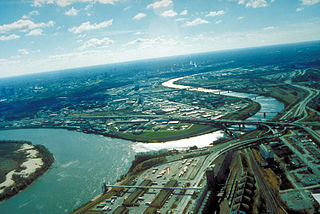
English: Aerial view of Kansas City, Kansas, looking southwest. The Kansas River (right-center) joins the Missouri River (left). A small piece of Kansas City, Missouri is visible on the left of the Missouri River. |
| Location | City of Kansas City, State of Kansas, United States of America 39°6′54.64″N 94°36′36.34″W / 39.1151778°N 94.6100944°W |
| తేదీ | Taken on 6 ఏప్రిల్ 1999 |
| మూలం |
U.S. Army Corp of Engineers Digital Visual Library Image page Image description page Digital Visual Library home page |
| కర్త | U.S. Army Corps of Engineers, photographer unknown |
లైసెన్సింగ్
This image or file is a work of a U.S. Army Corps of Engineers soldier or employee, taken or made as part of that person's official duties. As a work of the U.S. federal government, the image is in the public domain.
|
ఫైలు చరితం
తేదీ/సమయం ను నొక్కి ఆ సమయాన ఫైలు ఎలా ఉండేదో చూడవచ్చు.
| తేదీ/సమయం | నఖచిత్రం | కొలతలు | వాడుకరి | వ్యాఖ్య | |
|---|---|---|---|---|---|
| ప్రస్తుత | 01:48, 17 మార్చి 2007 | | 1,500 × 1,001 (579 KB) | DanMS | {{Information | Description = Aerial view of Kansas City, Kansas, looking southwest. The Kansas River (right-center) joins the Missouri River (left). A small piece of Kansas City, Missouri is visible on the left of the Missouri River. | Source = U.S. |
లింకులు
ఈ ఫైలును వాడుతున్న పేజీలు లేవు.
సార్వత్రిక ఫైలు వాడుక
ఈ దస్త్రాన్ని ఈ క్రింది ఇతర వికీలు ఉపయోగిస్తున్నాయి:
- bo.wikipedia.org లో వాడుక
- br.wikipedia.org లో వాడుక
- cs.wikipedia.org లో వాడుక
- da.wikipedia.org లో వాడుక
- de.wikipedia.org లో వాడుక
- en.wikipedia.org లో వాడుక
- eo.wikipedia.org లో వాడుక
- es.wikipedia.org లో వాడుక
- fr.wikipedia.org లో వాడుక
- gd.wikipedia.org లో వాడుక
- gu.wikipedia.org లో వాడుక
- gv.wikipedia.org లో వాడుక
- hsb.wikipedia.org లో వాడుక
- hu.wikipedia.org లో వాడుక
- hy.wikipedia.org లో వాడుక
- id.wikipedia.org లో వాడుక
- ja.wikipedia.org లో వాడుక
- kn.wikipedia.org లో వాడుక
- ko.wikipedia.org లో వాడుక
- kw.wikipedia.org లో వాడుక
- ky.wikipedia.org లో వాడుక
- la.wikipedia.org లో వాడుక
- mr.wikipedia.org లో వాడుక
- mt.wikipedia.org లో వాడుక
- sc.wikipedia.org లో వాడుక
- simple.wikipedia.org లో వాడుక
- sk.wikipedia.org లో వాడుక
- sv.wikipedia.org లో వాడుక
- ug.wikipedia.org లో వాడుక
- uk.wikipedia.org లో వాడుక
- zh-min-nan.wikipedia.org లో వాడుక