దస్త్రం:Kashmir Railway JUSBRL Project Map.png
Jump to navigation
Jump to search

ఈ మునుజూపు పరిమాణం: 600 × 600 పిక్సెళ్ళు. ఇతర రిజల్యూషన్లు: 240 × 240 పిక్సెళ్ళు | 480 × 480 పిక్సెళ్ళు | 768 × 768 పిక్సెళ్ళు | 1,024 × 1,024 పిక్సెళ్ళు | 1,500 × 1,500 పిక్సెళ్ళు.
అసలు దస్త్రం (1,500 × 1,500 పిక్సెళ్ళు, ఫైలు పరిమాణం: 1.08 MB, MIME రకం: image/png)
This is a file from the Wikimedia Commons. Information from its description page there is shown below. Commons is a freely licensed media file repository. You can help. |
సారాంశం
| వివరణ |
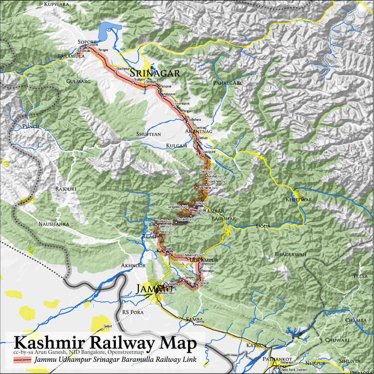
English: Route map of the Jammu Udhampur Srinagar Baramulla Railway Link Project. The section between Udhampur and Qazigund is under construction. |
||
| తేదీ | |||
| మూలం | స్వంత కృతి, borders: naturalearthdata.com, data:openstreetmap, topography:srtm | ||
| కర్త |
|
లైసెన్సింగ్
నేను, ఈ కృతి యొక్క కాపీహక్కుదారుని, దీన్ని ఈ లైసెన్సు క్రింద ఇందుమూలముగా ప్రచురిస్తున్నాను:
ఈ దస్త్రం క్రియేటివ్ కామన్స్ Attribution-Share Alike 3.0 Unported లైసెన్సు క్రింద లభ్యం.
- ఇలా చేసేందుకు మీకు స్వేచ్ఛ ఉంది:
- పంచుకోడానికి – ఈ కృతిని కాపీ చేసుకోవచ్చు, పంపిణీ చేయవచ్చు, ప్రసారమూ చేయవచ్చు
- రీమిక్స్ చేయడానికి – కృతిని అనుకరించడానికి
- క్రింది షరతులకు లోబడి:
- ఆపాదింపు – సముచితమైన శ్రేయస్సును ఇవ్వాలి, లైసెన్సుకు లింకు ఇవ్వాలి, మార్పులేమైనా చేస్తే వాటిని సూచించాలి. అందుకు సముచితమైన పద్ధతి దేన్నైనా అవలంబించవచ్చు. కానీ మీకూ మీ వాడుకకూ హక్కుదారు అనుమతించారు అనే అర్థం వచ్చేటట్లుగా మాత్రం కాదు.
- share alike – మీరు ఈ కృతిని అనుకరిస్తే, మారిస్తే, లేదా మెరుగుపరిస్తే తత్ఫలిత కృతిని ఇదే లైసెన్సు లేదా దీనికి అనుగుణ్యమైన లైసెన్సు క్రింద మాత్రమే పంపిణీ చేయాలి.
ఫైలు చరితం
తేదీ/సమయం ను నొక్కి ఆ సమయాన ఫైలు ఎలా ఉండేదో చూడవచ్చు.
| తేదీ/సమయం | నఖచిత్రం | కొలతలు | వాడుకరి | వ్యాఖ్య | |
|---|---|---|---|---|---|
| ప్రస్తుత | 07:55, 24 జూలై 2014 | | 1,500 × 1,500 (1.08 MB) | Cited third page | enhance contrast |
| 10:19, 17 ఆగస్టు 2011 |  | 1,500 × 1,500 (660 KB) | Planemad |
లింకులు
కింది పేజీలలో ఈ ఫైలుకు లింకులు ఉన్నాయి:
సార్వత్రిక ఫైలు వాడుక
ఈ దస్త్రాన్ని ఈ క్రింది ఇతర వికీలు ఉపయోగిస్తున్నాయి:
- ar.wikipedia.org లో వాడుక
- bn.wikipedia.org లో వాడుక
- de.wikipedia.org లో వాడుక
- de.wikinews.org లో వాడుక
- en.wikipedia.org లో వాడుక
- fa.wikipedia.org లో వాడుక
- fr.wikipedia.org లో వాడుక
- hu.wikipedia.org లో వాడుక
- ks.wikipedia.org లో వాడుక
- ml.wikipedia.org లో వాడుక
- mr.wikipedia.org లో వాడుక
- ru.wikipedia.org లో వాడుక
- ta.wikipedia.org లో వాడుక
- tr.wikipedia.org లో వాడుక
- www.wikidata.org లో వాడుక
- yi.wikipedia.org లో వాడుక