దస్త్రం:Mackinac Island topographic map-en.svg
Jump to navigation
Jump to search

ఈ ఫైలు SVG కు చెందిన ఈ మునుజూపు PNG పరిమాణం: 545 × 600 పిక్సెళ్ళు. ఇతర రిజల్యూషన్లు: 218 × 240 పిక్సెళ్ళు | 436 × 480 పిక్సెళ్ళు | 698 × 768 పిక్సెళ్ళు | 931 × 1,024 పిక్సెళ్ళు | 1,862 × 2,048 పిక్సెళ్ళు | 1,200 × 1,320 పిక్సెళ్ళు.
అసలు దస్త్రం (SVG ఫైలు, నామమాత్రంగా 1,200 × 1,320 పిక్సెళ్ళు, ఫైలు పరిమాణం: 457 KB)
This is a file from the Wikimedia Commons. Information from its description page there is shown below. Commons is a freely licensed media file repository. You can help. |
సారాంశం
| Camera location | | View this and other nearby images on: OpenStreetMap |
|---|
| వివరణ |
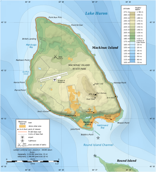
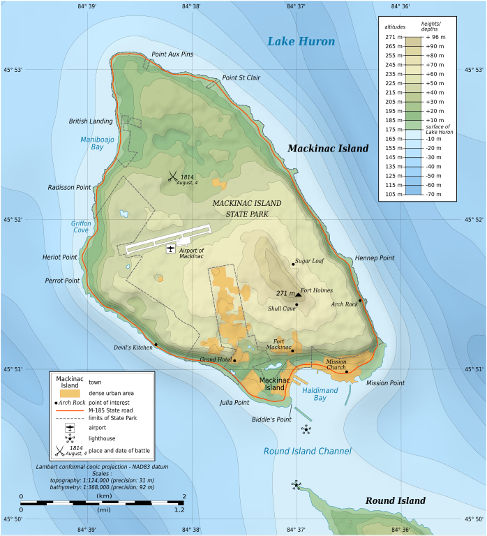
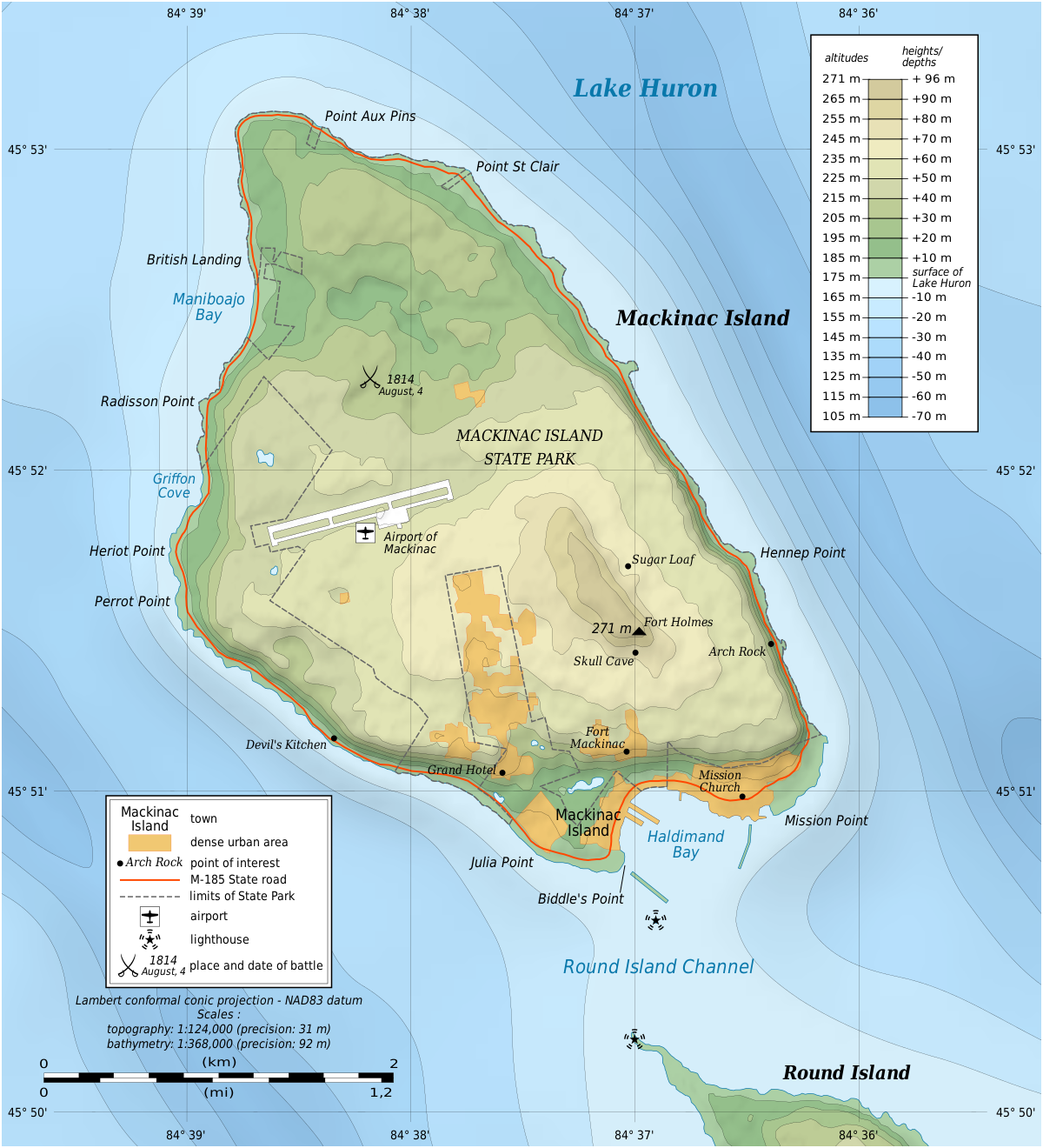
English: Topographic map in English of Mackinac Island, Lake Huron, Michigan, USA.
Note: The shaded relief is a raster image embedded in the SVG file. Français : Carte topographique en anglais de l'Île Mackinac, Lac Huron, Michigan, États-Unis. Note : Les ombres du relief sont une image bitmap embarquée dans le fichier SVG. Lambert conformal conic projection – NAD83 datum
|
||
| తేదీ | |||
| మూలం |
స్వంత కృతి
|
||
| కర్త | Eric Gaba (Sting - fr:Sting) | ||
| అనుమతి (ఈ దస్త్రాన్ని పునర్వినియోగించుకోవడం) |
|
||
| ఇతర కూర్పులు |
|


|
This SVG file contains embedded text that can be translated into your language, using any capable SVG editor, text editor or the SVG Translate tool. For more information see: About translating SVG files. |
లైసెన్సింగ్
నేను, ఈ కృతి యొక్క కాపీహక్కుదారుని, దీన్ని ఇందుమూలముగా ఈ లైసెన్సుల క్రింద ప్రచురిస్తున్నాను:

|
ఈ కృతి యొక్క కర్తనైన నేను, ఇక నుండీ ఈ కృతిని కాపీ చేసుకోవడానికి, పంచి పెట్టడానికి మరియు/లేదా మార్పులు-చేర్పులు చేసుకోవడానికి GFDL, లైసెన్సు వెర్షను 1.2 లేదా దాని తరువాత స్వేచ్చా సాఫ్టువేరు ఫౌండేషను విడుదలచేసే ఏ GFDL లైసెన్సు ద్వారా నయినా అనుమతి ఇస్తున్నాను; ఈ కృతిలో మార్చకూడని బాగాలు లేవు, Front-Cover పాఠం లేదు, Back-Cover పాఠం లేదు. ఈ లైసెన్సు యొక్క పత్రం నకలును "జిఎన్యూ ఉచిత డాక్యుమెంటేషను లైసెన్సు" అని పిలుస్తున్న విభాగంలో ఉంది. |
ఈ దస్త్రం క్రియేటివ్ కామన్స్ Attribution-Share Alike 3.0 Unported లైసెన్సు క్రింద లభ్యం.
- ఇలా చేసేందుకు మీకు స్వేచ్ఛ ఉంది:
- పంచుకోడానికి – ఈ కృతిని కాపీ చేసుకోవచ్చు, పంపిణీ చేయవచ్చు, ప్రసారమూ చేయవచ్చు
- రీమిక్స్ చేయడానికి – కృతిని అనుకరించడానికి
- క్రింది షరతులకు లోబడి:
- ఆపాదింపు – సముచితమైన శ్రేయస్సును ఇవ్వాలి, లైసెన్సుకు లింకు ఇవ్వాలి, మార్పులేమైనా చేస్తే వాటిని సూచించాలి. అందుకు సముచితమైన పద్ధతి దేన్నైనా అవలంబించవచ్చు. కానీ మీకూ మీ వాడుకకూ హక్కుదారు అనుమతించారు అనే అర్థం వచ్చేటట్లుగా మాత్రం కాదు.
- share alike – మీరు ఈ కృతిని అనుకరిస్తే, మారిస్తే, లేదా మెరుగుపరిస్తే తత్ఫలిత కృతిని ఇదే లైసెన్సు లేదా దీనికి అనుగుణ్యమైన లైసెన్సు క్రింద మాత్రమే పంపిణీ చేయాలి.
పైవాటిలో మీకు నచ్చిన లైసెన్సునును ఎంచుకోవచ్చు.
ఫైలు చరితం
తేదీ/సమయం ను నొక్కి ఆ సమయాన ఫైలు ఎలా ఉండేదో చూడవచ్చు.
| తేదీ/సమయం | నఖచిత్రం | కొలతలు | వాడుకరి | వ్యాఖ్య | |
|---|---|---|---|---|---|
| ప్రస్తుత | 17:43, 7 జూలై 2010 | | 1,200 × 1,320 (457 KB) | Liandrei | fix |
| 17:39, 7 జూలై 2010 |  | 1,196 × 1,316 (133 KB) | Liandrei | fix | |
| 17:35, 7 జూలై 2010 |  | 1,196 × 1,316 (133 KB) | Liandrei | Removed border | |
| 01:37, 9 జూన్ 2009 |  | 1,200 × 1,320 (462 KB) | Sting | == Summary == {{Location|45|51|53|N|84|37|30|W|scale:30000}} {{Information| |Description={{en|Topographic map in English of Mackinac Island, Lake Huron, Michigan, USA.<br/>''Note: The shaded relief is a raster image embedded in th |
లింకులు
ఈ ఫైలును వాడుతున్న పేజీలు లేవు.
సార్వత్రిక ఫైలు వాడుక
ఈ దస్త్రాన్ని ఈ క్రింది ఇతర వికీలు ఉపయోగిస్తున్నాయి:
- ca.wikipedia.org లో వాడుక
- de.wikipedia.org లో వాడుక
- en.wikipedia.org లో వాడుక
- Mackinac Island
- Fort Mackinac
- Fort Holmes
- Mackinac Island State Park
- Andrew Holmes (army officer)
- Battle of Mackinac Island (1814)
- Mission House (Mackinac Island)
- Arch Rock (Mackinac Island)
- Round Island Light, Michigan
- Marquette Park (Mackinac Island)
- Round Island Passage Light
- Wikipedia:Graphics Lab/Photography workshop/Archive/Jul 2010
- Portal:Islands/Selected article
- Portal:Islands/Selected article/55
- en.wikivoyage.org లో వాడుక
- es.wikipedia.org లో వాడుక
- fr.wikipedia.org లో వాడుక
- ja.wikipedia.org లో వాడుక
- kk.wikipedia.org లో వాడుక
- nl.wikipedia.org లో వాడుక
- pl.wikipedia.org లో వాడుక
- ru.wikipedia.org లో వాడుక
- www.wikidata.org లో వాడుక
- xmf.wikipedia.org లో వాడుక
- zh.wikipedia.org లో వాడుక