దస్త్రం:Maharashtra Divisions Eng.svg
Jump to navigation
Jump to search

ఈ ఫైలు SVG కు చెందిన ఈ మునుజూపు PNG పరిమాణం: 759 × 599 పిక్సెళ్ళు. ఇతర రిజల్యూషన్లు: 304 × 240 పిక్సెళ్ళు | 608 × 480 పిక్సెళ్ళు | 973 × 768 పిక్సెళ్ళు | 1,280 × 1,011 పిక్సెళ్ళు | 2,560 × 2,022 పిక్సెళ్ళు | 3,106 × 2,453 పిక్సెళ్ళు.
అసలు దస్త్రం (SVG ఫైలు, నామమాత్రంగా 3,106 × 2,453 పిక్సెళ్ళు, ఫైలు పరిమాణం: 289 KB)
This is a file from the Wikimedia Commons. Information from its description page there is shown below. Commons is a freely licensed media file repository. You can help. |
సారాంశం
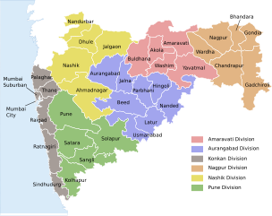
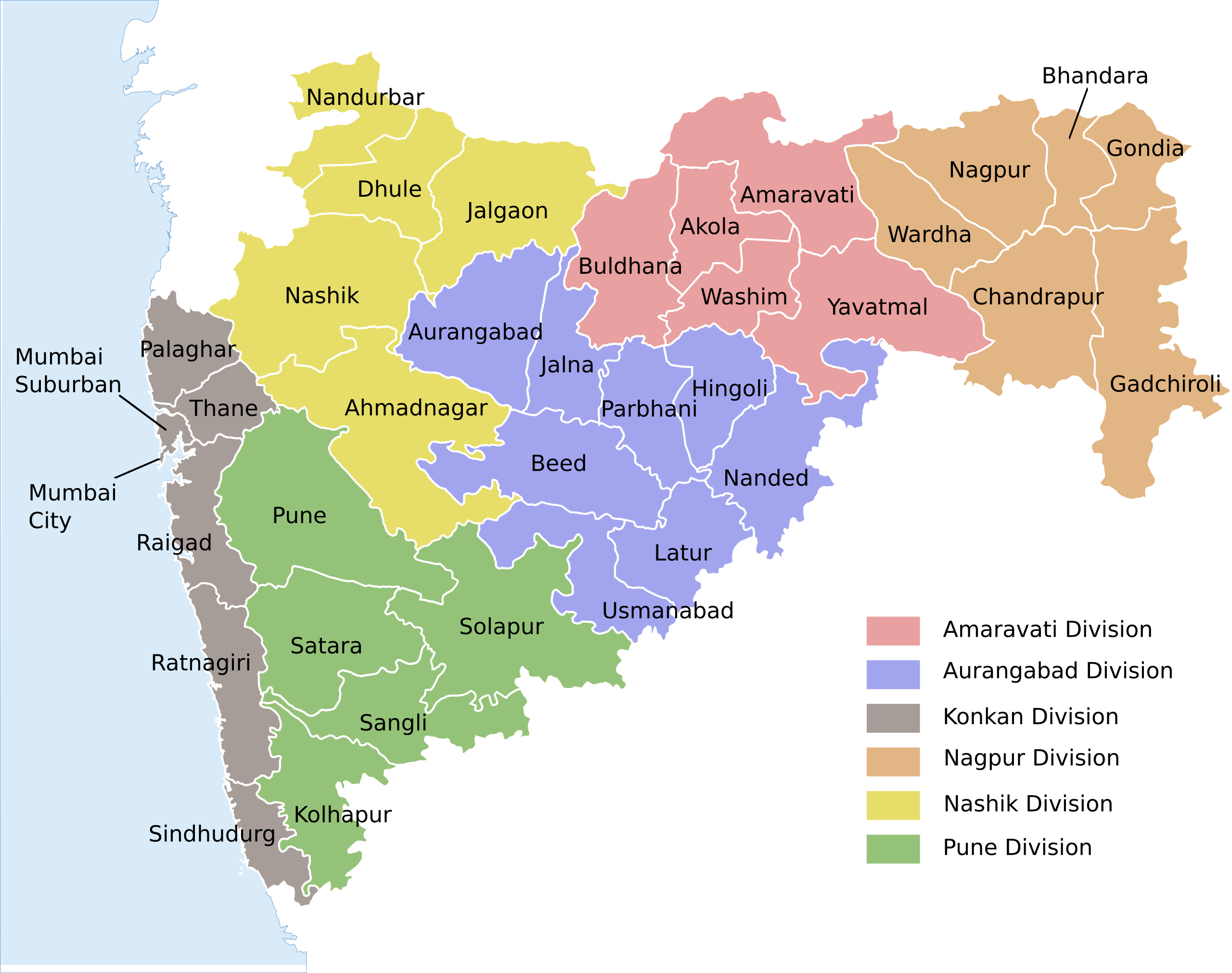
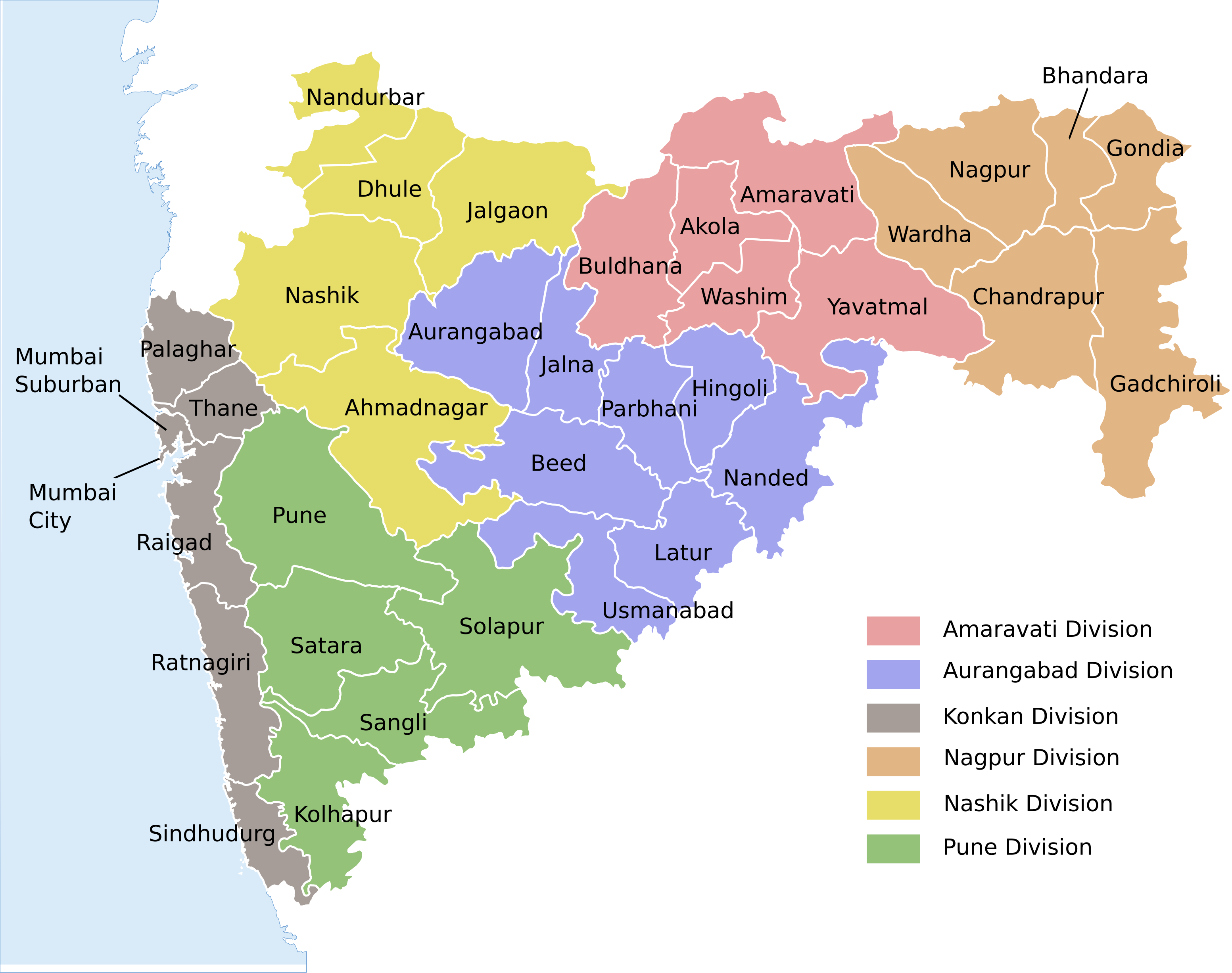
| వివరణ | Locator map of the state of en:Maharashtra, India with district boundaries and Admin. divisions |
| తేదీ | (UTC) |
| మూలం | |
| కర్త |
|
| ఇతర కూర్పులు |
[]
|


| This is a retouched picture, which means that it has been digitally altered from its original version. Modifications: Added colour coding & divisions. The original can be viewed here: Maharashtra locator map.svg:
|
ఈ దస్త్రం క్రియేటివ్ కామన్స్ Attribution-Share Alike 3.0 Unported లైసెన్సు క్రింద లభ్యం.
- ఇలా చేసేందుకు మీకు స్వేచ్ఛ ఉంది:
- పంచుకోడానికి – ఈ కృతిని కాపీ చేసుకోవచ్చు, పంపిణీ చేయవచ్చు, ప్రసారమూ చేయవచ్చు
- రీమిక్స్ చేయడానికి – కృతిని అనుకరించడానికి
- క్రింది షరతులకు లోబడి:
- ఆపాదింపు – సముచితమైన శ్రేయస్సును ఇవ్వాలి, లైసెన్సుకు లింకు ఇవ్వాలి, మార్పులేమైనా చేస్తే వాటిని సూచించాలి. అందుకు సముచితమైన పద్ధతి దేన్నైనా అవలంబించవచ్చు. కానీ మీకూ మీ వాడుకకూ హక్కుదారు అనుమతించారు అనే అర్థం వచ్చేటట్లుగా మాత్రం కాదు.
- share alike – మీరు ఈ కృతిని అనుకరిస్తే, మారిస్తే, లేదా మెరుగుపరిస్తే తత్ఫలిత కృతిని ఇదే లైసెన్సు లేదా దీనికి అనుగుణ్యమైన లైసెన్సు క్రింద మాత్రమే పంపిణీ చేయాలి.
అసలు ఎక్కింపుల చిట్టా
This image is a derivative work of the following images:
- File:Maharashtra_locator_map.svg licensed with Cc-by-sa-3.0
- 2008-12-21T12:08:04Z Planemad 2789x2232 (365091 Bytes) {{Information |Description={{en|1=map}} |Source=Own work by uploader |Author=[[User:PlaneMad|PlaneMad]] |Date= |Permission= |other_versions= }}
Uploaded with derivativeFX
ఫైలు చరితం
తేదీ/సమయం ను నొక్కి ఆ సమయాన ఫైలు ఎలా ఉండేదో చూడవచ్చు.
| తేదీ/సమయం | నఖచిత్రం | కొలతలు | వాడుకరి | వ్యాఖ్య | |
|---|---|---|---|---|---|
| ప్రస్తుత | 04:54, 15 ఆగస్టు 2020 | | 3,106 × 2,453 (289 KB) | শরদিন্দু ভট্টাচার্য্য | File uploaded using svgtranslate tool (https://svgtranslate.toolforge.org/). Added translation for bn. |
| 02:40, 3 ఆగస్టు 2020 |  | 3,106 × 2,453 (262 KB) | C1MM | Added Palaghar | |
| 16:09, 18 ఆగస్టు 2011 |  | 3,106 × 2,453 (248 KB) | Kaajawa | {{Information |Description=Locator map of the state of en:Maharashtra, India with district boundaries and Admin. divisions |Source=*File:Maharashtra_locator_map.svg |Date=2011-08-18 16:06 (UTC) |Author=*[[:File:Maharashtra_locator_m |
లింకులు
కింది పేజీలలో ఈ ఫైలుకు లింకులు ఉన్నాయి:
సార్వత్రిక ఫైలు వాడుక
ఈ దస్త్రాన్ని ఈ క్రింది ఇతర వికీలు ఉపయోగిస్తున్నాయి:
- awa.wikipedia.org లో వాడుక
- bh.wikipedia.org లో వాడుక
- bn.wikipedia.org లో వాడుక
- de.wikipedia.org లో వాడుక
- dty.wikipedia.org లో వాడుక
- en.wikipedia.org లో వాడుక
- eu.wikipedia.org లో వాడుక
- fi.wikipedia.org లో వాడుక
- fr.wikipedia.org లో వాడుక
- ha.wikipedia.org లో వాడుక
- hi.wikipedia.org లో వాడుక
- मुम्बई
- महाराष्ट्र
- पुणे
- नागपुर
- माथेरान
- मराठी भाषा
- विदर्भ
- अकोला
- नाशिक
- वर्धा
- अमरावती
- ठाणे
- जुन्नर तालुका
- जलगाँव
- अहमदनगर जिला
- अकोला जिला
- औरंगाबाद जिला, महाराष्ट्र
- अमरावती जिला
- बीड जिला
- भंडारा जिला
- बुलढाणा जिला
- चंद्रपुर जिला
- जालना जिला
- हिंगोली जिला
- गोंदिया जिला
- गढ़चिरौली जिला
- धुले जिला
- रायगढ़ जिला, महाराष्ट्र
- पुणे जिला
- परभणी जिला
- उस्मानाबाद जिला
- नाशिक जिला
- नंदुरबार जिला
ఈ దస్త్రపు మరింత సార్వత్రిక వాడుకను చూడండి.