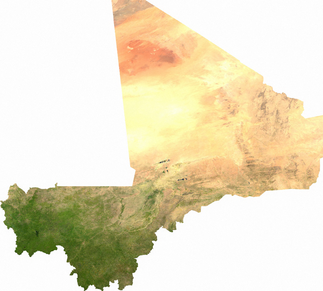
దస్త్రం:Mali sat.png
Jump to navigation
Jump to search

ఈ మునుజూపు పరిమాణం: 665 × 599 పిక్సెళ్ళు. ఇతర రిజల్యూషన్లు: 266 × 240 పిక్సెళ్ళు | 533 × 480 పిక్సెళ్ళు | 852 × 768 పిక్సెళ్ళు | 1,137 × 1,024 పిక్సెళ్ళు | 1,979 × 1,783 పిక్సెళ్ళు.
అసలు దస్త్రం (1,979 × 1,783 పిక్సెళ్ళు, ఫైలు పరిమాణం: 3.58 MB, MIME రకం: image/png)
This is a file from the Wikimedia Commons. Information from its description page there is shown below. Commons is a freely licensed media file repository. You can help. |
ECW to TIFF to PNG (compression level 9).
| This file is in the public domain, because it was generated by a user, using free sources available at The Map Library.
Note that this does not include the maps in the Global Administrative Areas section of the homepage. |
ఫైలు చరితం
తేదీ/సమయం ను నొక్కి ఆ సమయాన ఫైలు ఎలా ఉండేదో చూడవచ్చు.
| తేదీ/సమయం | నఖచిత్రం | కొలతలు | వాడుకరి | వ్యాఖ్య | |
|---|---|---|---|---|---|
| ప్రస్తుత | 02:32, 14 జూలై 2006 | | 1,979 × 1,783 (3.58 MB) | Unquietwiki | ECW to TIFF to PNG (compression level 9). {{PD-MapLibrary}} |
లింకులు
కింది పేజీలలో ఈ ఫైలుకు లింకులు ఉన్నాయి:
సార్వత్రిక ఫైలు వాడుక
ఈ దస్త్రాన్ని ఈ క్రింది ఇతర వికీలు ఉపయోగిస్తున్నాయి:
- af.wikipedia.org లో వాడుక
- als.wikipedia.org లో వాడుక
- ar.wikipedia.org లో వాడుక
- bs.wikipedia.org లో వాడుక
- ca.wikipedia.org లో వాడుక
- de.wikipedia.org లో వాడుక
- de.wikivoyage.org లో వాడుక
- en.wikipedia.org లో వాడుక
- es.wikipedia.org లో వాడుక
- fi.wikipedia.org లో వాడుక
- fr.wikipedia.org లో వాడుక
- hu.wikipedia.org లో వాడుక
- hy.wikipedia.org లో వాడుక
- id.wikipedia.org లో వాడుక
- incubator.wikimedia.org లో వాడుక
- io.wikipedia.org లో వాడుక
- it.wikipedia.org లో వాడుక
- ka.wikipedia.org లో వాడుక
- ky.wikipedia.org లో వాడుక
- mdf.wikipedia.org లో వాడుక
- mn.wikipedia.org లో వాడుక
- pl.wikipedia.org లో వాడుక
- pt.wikipedia.org లో వాడుక
- ru.wikipedia.org లో వాడుక
- si.wikipedia.org లో వాడుక
- trv.wikipedia.org లో వాడుక
- uk.wikipedia.org లో వాడుక
- ur.wikipedia.org లో వాడుక
- vi.wikipedia.org లో వాడుక
- zh.wikipedia.org లో వాడుక