దస్త్రం:Map Europe 1923-en.svg
Jump to navigation
Jump to search

ఈ ఫైలు SVG కు చెందిన ఈ మునుజూపు PNG పరిమాణం: 800 × 543 పిక్సెళ్ళు. ఇతర రిజల్యూషన్లు: 320 × 217 పిక్సెళ్ళు | 640 × 434 పిక్సెళ్ళు | 1,024 × 695 పిక్సెళ్ళు | 1,280 × 869 పిక్సెళ్ళు | 2,560 × 1,738 పిక్సెళ్ళు | 1,037 × 704 పిక్సెళ్ళు.
అసలు దస్త్రం (SVG ఫైలు, నామమాత్రంగా 1,037 × 704 పిక్సెళ్ళు, ఫైలు పరిమాణం: 188 KB)
This is a file from the Wikimedia Commons. Information from its description page there is shown below. Commons is a freely licensed media file repository. You can help. |
| వివరణ |
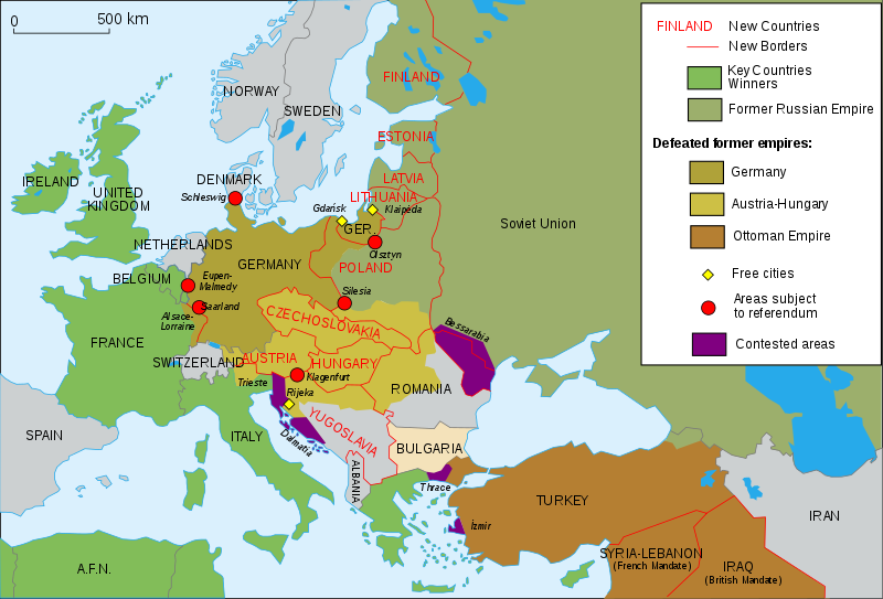
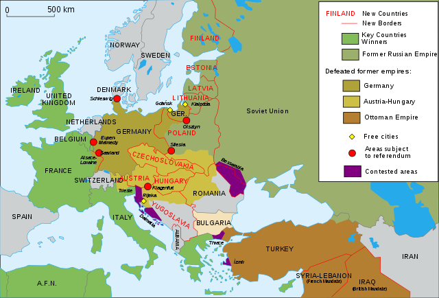
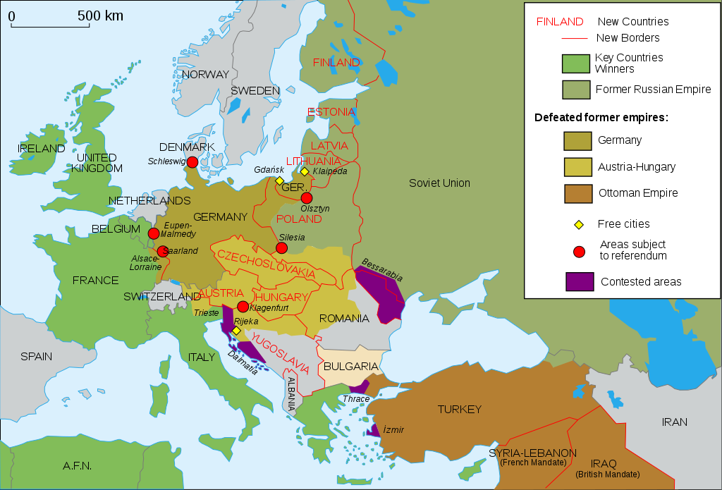
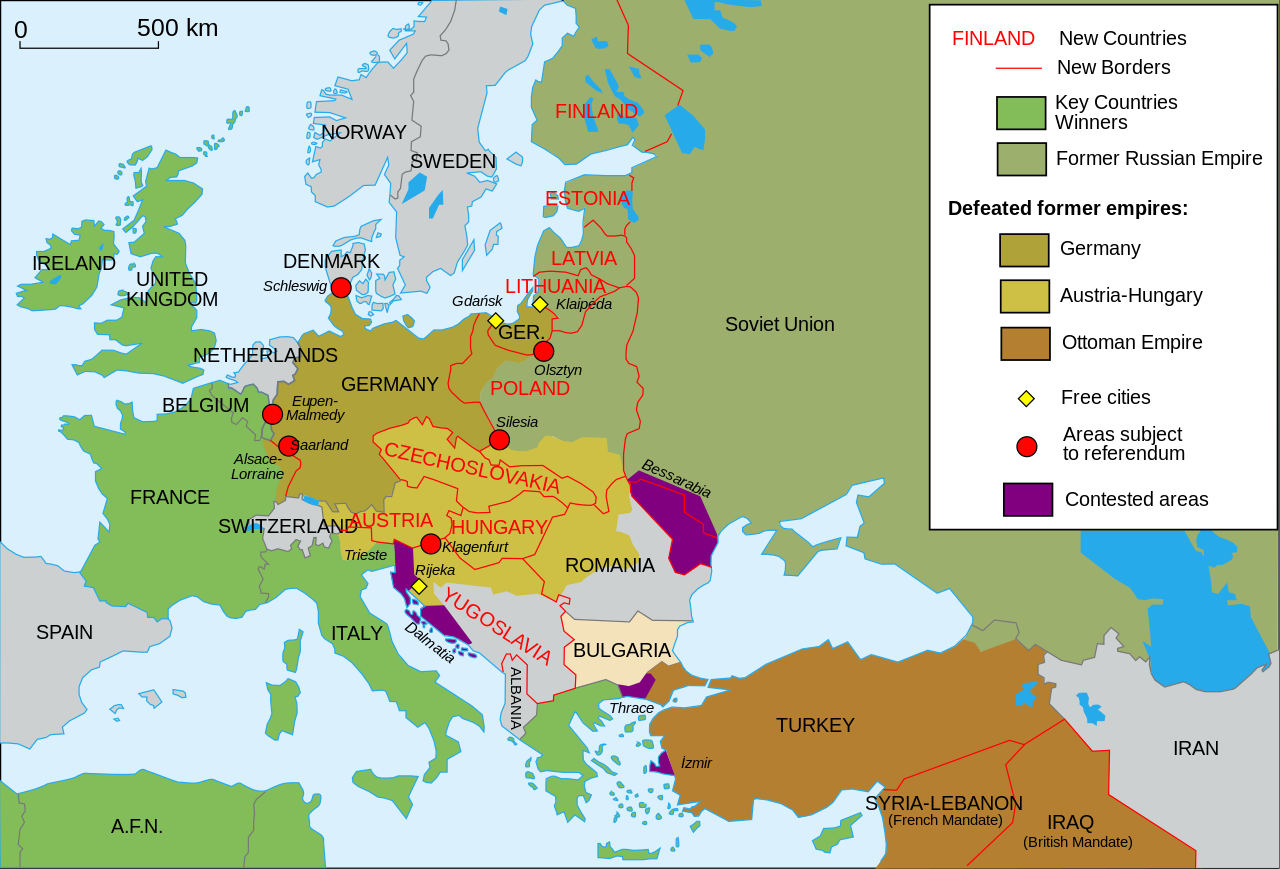
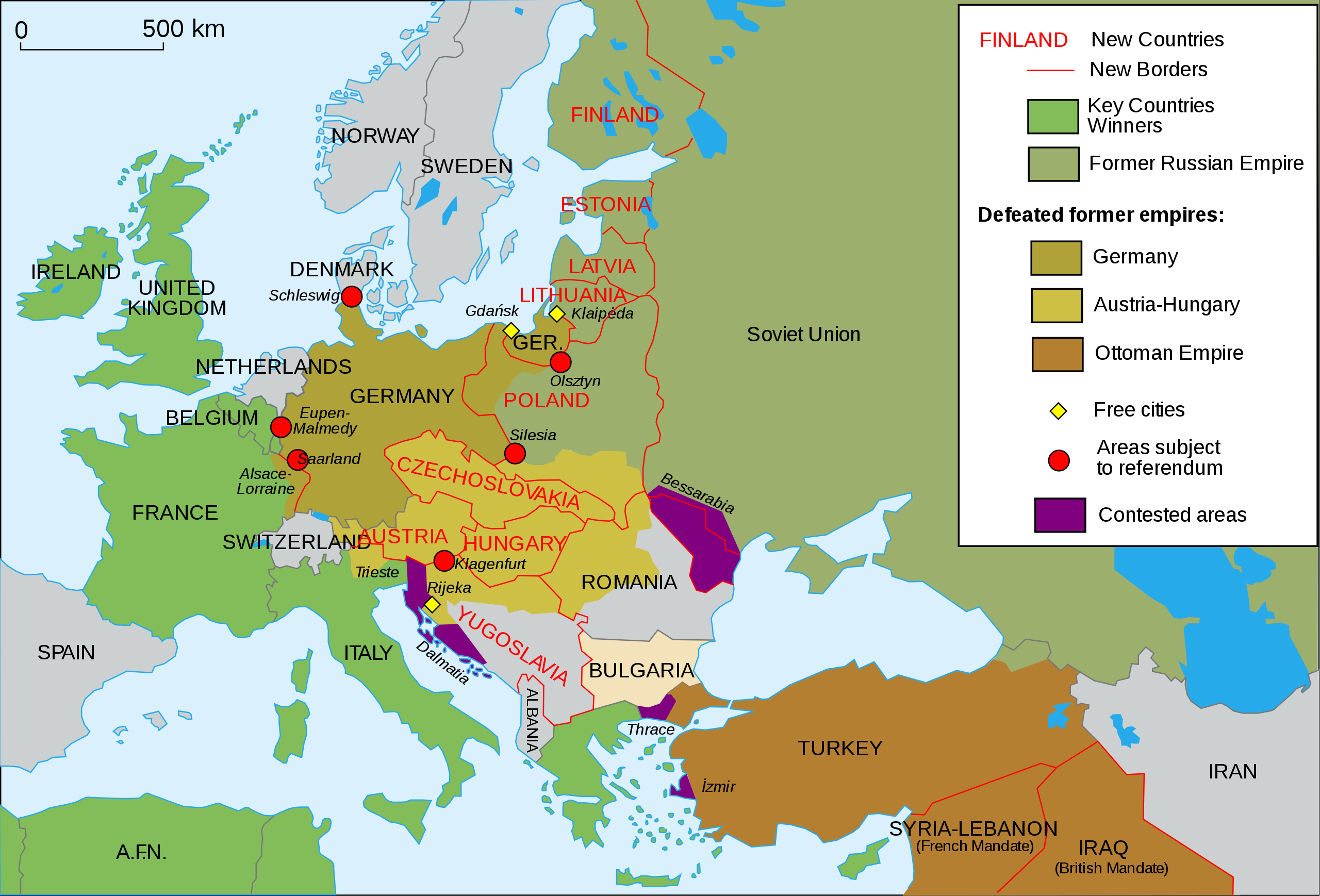
English: Map of Europe and Western Asia in 1923 after World War I Español: Mapa de Europa y Asia en 1923 Français : Carte de l'Europe en 1923. Português: Mapa da Europa e da Ásia em 1923 অসমীয়া: প্ৰথম বিশ্বযুদ্ধৰ পিছত ১৯২৩ চনত ইউৰোপ আৰু পশ্চিম এছিয়াৰ মানচিত্ৰ বাংলা : প্রথম বিশ্বযুদ্ধের পর ১৯২৩ সালে ইউরোপ ও পশ্চিম এশিয়ার মানচিত্র |
| తేదీ | (UTC) |
| మూలం | |
| కర్త |
|
| ఇతర కూర్పులు |
Derivative works of this file: []
|
| SVG పెరుగుదల | This vector image was created with Inkscape, or with something else. This file uses embedded text that can be easily translated using a text editor. |


నేను, ఈ కృతి యొక్క కాపీహక్కుదారుని, దీన్ని ఈ లైసెన్సు క్రింద ఇందుమూలముగా ప్రచురిస్తున్నాను:
ఈ దస్త్రం క్రియేటివ్ కామన్స్ ఆపాదింపు-యథాతథ పంచుకోలు 2.5 సాధారణం, 2.0 సాధారణం మరియు 1.0 సాధారణం లైసెన్సుల క్రింద లభ్యం.
- ఇలా చేసేందుకు మీకు స్వేచ్ఛ ఉంది:
- పంచుకోడానికి – ఈ కృతిని కాపీ చేసుకోవచ్చు, పంపిణీ చేయవచ్చు, ప్రసారమూ చేయవచ్చు
- రీమిక్స్ చేయడానికి – కృతిని అనుకరించడానికి
- క్రింది షరతులకు లోబడి:
- ఆపాదింపు – సముచితమైన శ్రేయస్సును ఇవ్వాలి, లైసెన్సుకు లింకు ఇవ్వాలి, మార్పులేమైనా చేస్తే వాటిని సూచించాలి. అందుకు సముచితమైన పద్ధతి దేన్నైనా అవలంబించవచ్చు. కానీ మీకూ మీ వాడుకకూ హక్కుదారు అనుమతించారు అనే అర్థం వచ్చేటట్లుగా మాత్రం కాదు.
- share alike – మీరు ఈ కృతిని అనుకరిస్తే, మారిస్తే, లేదా మెరుగుపరిస్తే తత్ఫలిత కృతిని ఇదే లైసెన్సు లేదా దీనికి అనుగుణ్యమైన లైసెన్సు క్రింద మాత్రమే పంపిణీ చేయాలి.
అసలు ఎక్కింపుల చిట్టా
This image is a derivative work of the following images:
- File:Map_Europe_1923-fr.svg licensed with Cc-by-sa-2.5,2.0,1.0, Cc-by-sa-2.5,2.0,1.0/en
- 2007-04-19T18:31:16Z Bibi Saint-Pol 1037x704 (191242 Bytes) {{Information |Description= {{en|Map of Europe in 1923.}} {{fr|Carte de l'Europe en 1923.}} |Source=Own work |Date=2007-02-16 |Author=[[User:Historicair|Historicair]] |Permission={{self2|GFDL|cc-by-sa-2.5,2.0,1.0}} |other_ver
Uploaded with derivativeFX

|
This SVG file contains embedded text that can be translated into your language, using any capable SVG editor, text editor or the SVG Translate tool. For more information see: About translating SVG files. |
ఫైలు చరితం
తేదీ/సమయం ను నొక్కి ఆ సమయాన ఫైలు ఎలా ఉండేదో చూడవచ్చు.
| తేదీ/సమయం | నఖచిత్రం | కొలతలు | వాడుకరి | వ్యాఖ్య | |
|---|---|---|---|---|---|
| ప్రస్తుత | 13:42, 11 నవంబరు 2015 | | 1,037 × 704 (188 KB) | Oosterhagen | The Netherlands as neutral |
| 14:24, 15 ఆగస్టు 2015 |  | 1,037 × 704 (177 KB) | Fluteflute | Correct misspelling. Sweeden -> Sweden | |
| 16:21, 13 జనవరి 2009 |  | 1,037 × 704 (187 KB) | Fluteflute | small text changes | |
| 16:17, 13 జనవరి 2009 |  | 1,037 × 704 (187 KB) | Fluteflute | {{Information |Description={{en|Map of Europe in 1923.}} {{fr|Carte de l'Europe en 1923.}} |Source=*File:Map_Europe_1923-fr.svg |Date=2009-01-13 16:16 (UTC) |Author=*derivative work: ~~~ *File:Map_Europe_1923-fr.svg: [[User:Historicair|Histori |
లింకులు
కింది పేజీలలో ఈ ఫైలుకు లింకులు ఉన్నాయి:
సార్వత్రిక ఫైలు వాడుక
ఈ దస్త్రాన్ని ఈ క్రింది ఇతర వికీలు ఉపయోగిస్తున్నాయి:
- af.wikipedia.org లో వాడుక
- ar.wikipedia.org లో వాడుక
- azb.wikipedia.org లో వాడుక
- az.wikipedia.org లో వాడుక
- be-tarask.wikipedia.org లో వాడుక
- ca.wikipedia.org లో వాడుక
- ckb.wikipedia.org లో వాడుక
- cy.wikipedia.org లో వాడుక
- en.wikipedia.org లో వాడుక
- Molotov–Ribbentrop Pact
- Nation state
- Self-determination
- Treaty of Versailles
- Woodrow Wilson
- 20th century
- Flight and expulsion of Germans (1944–1950)
- Balkanization
- Aftermath of World War I
- Revanchism
- Causes of World War II
- Territorial evolution of Russia
- History of Western civilization
- List of irredentist claims or disputes
- World War I
- List of national border changes (1914–present)
- Presidency of Woodrow Wilson
- Presidency of Warren G. Harding
- January 1920
- Wikipedia:Graphics Lab/Map workshop/Archive/2016
- Portal:Modern history
- Wikipedia:WikiProject Military history/News/June 2019/Op-ed
- History of U.S. foreign policy, 1913–1933
- User:Sm8900/harding
- en.wikibooks.org లో వాడుక
- eo.wikipedia.org లో వాడుక
- eu.wikipedia.org లో వాడుక
- fa.wikipedia.org లో వాడుక
- fi.wikipedia.org లో వాడుక
- fi.wikibooks.org లో వాడుక
- ga.wikipedia.org లో వాడుక
- hy.wikipedia.org లో వాడుక
- hyw.wikipedia.org లో వాడుక
- id.wikipedia.org లో వాడుక
- it.wikipedia.org లో వాడుక
ఈ దస్త్రపు మరింత సార్వత్రిక వాడుకను చూడండి.