దస్త్రం:Map of Ajanta Caves.svg
Jump to navigation
Jump to search

ఈ ఫైలు SVG కు చెందిన ఈ మునుజూపు PNG పరిమాణం: 553 × 600 పిక్సెళ్ళు. ఇతర రిజల్యూషన్లు: 221 × 240 పిక్సెళ్ళు | 443 × 480 పిక్సెళ్ళు | 708 × 768 పిక్సెళ్ళు | 944 × 1,024 పిక్సెళ్ళు | 1,889 × 2,048 పిక్సెళ్ళు | 1,081 × 1,172 పిక్సెళ్ళు.
అసలు దస్త్రం (SVG ఫైలు, నామమాత్రంగా 1,081 × 1,172 పిక్సెళ్ళు, ఫైలు పరిమాణం: 144 KB)
This is a file from the Wikimedia Commons. Information from its description page there is shown below. Commons is a freely licensed media file repository. You can help. |
సారాంశం
| వివరణ |
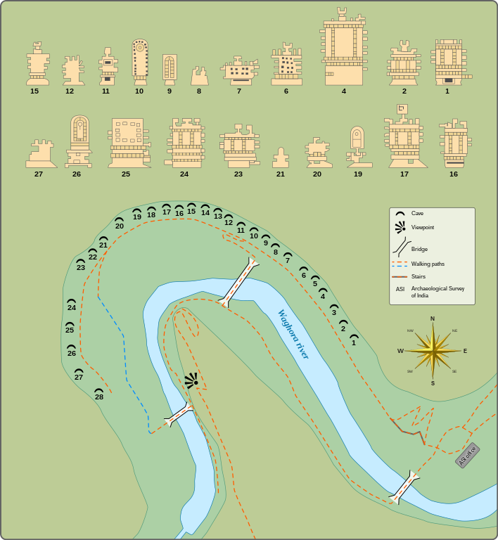
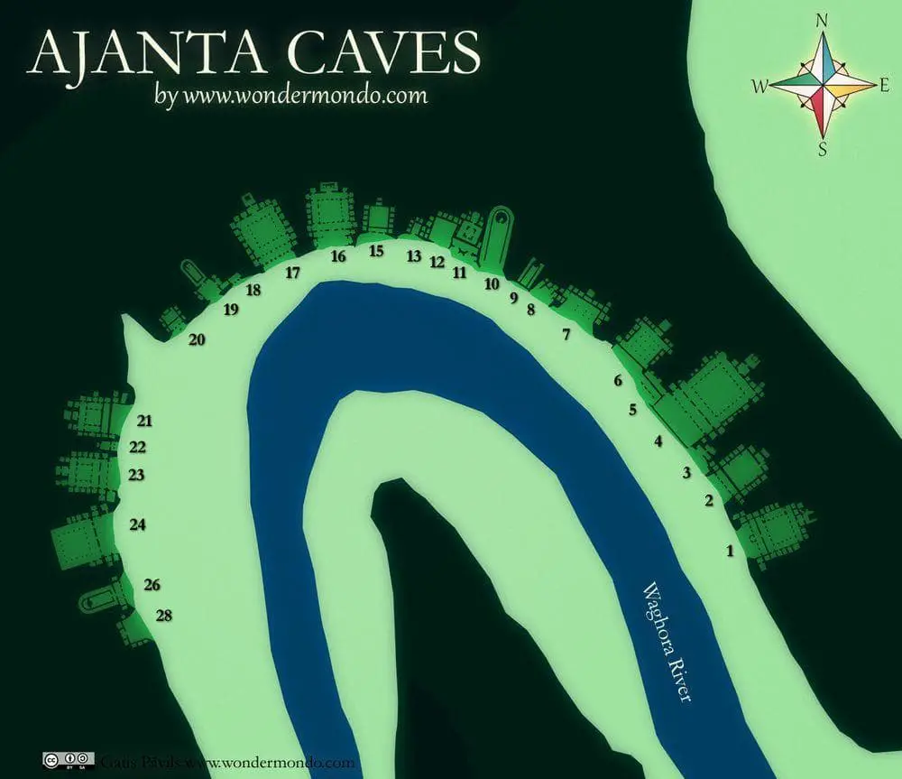
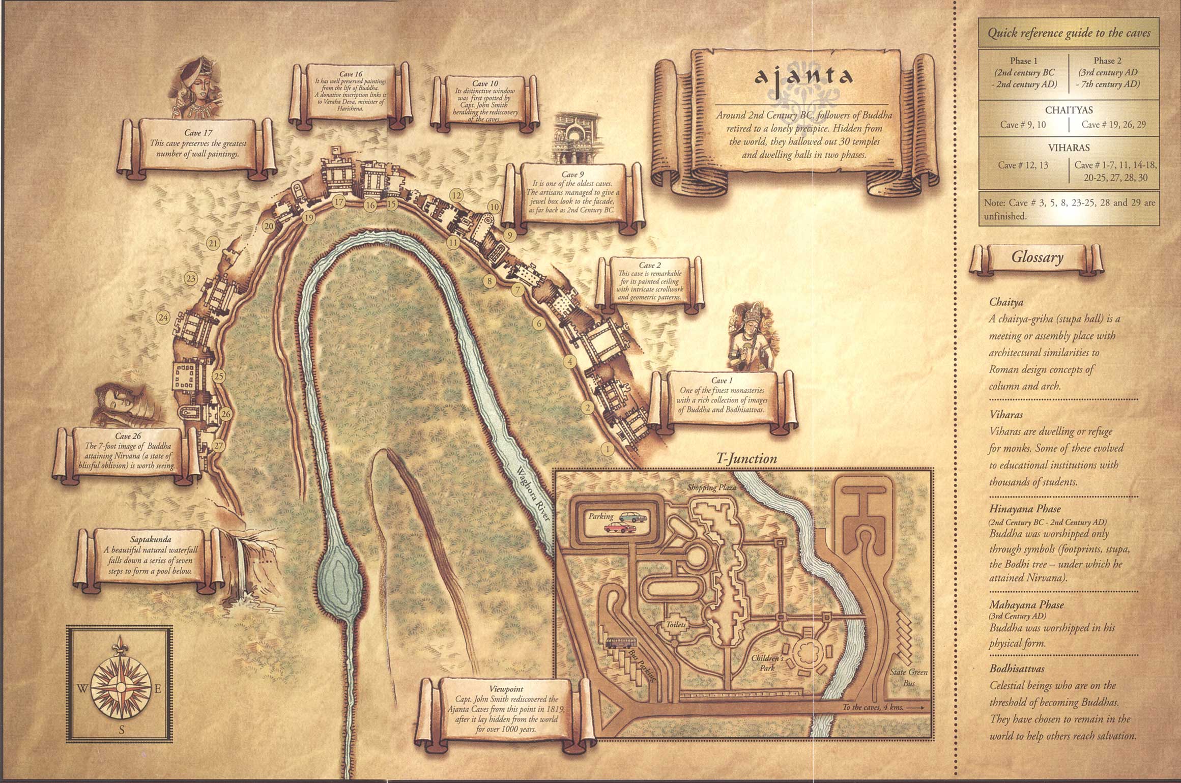
English: Maps and plans of the Ajanta Caves
|
|||
| తేదీ | ||||
| మూలం |
స్వంత కృతి
Information from:
|
|||
| కర్త | Goran_tek-en | |||
| అనుమతి (ఈ దస్త్రాన్ని పునర్వినియోగించుకోవడం) |
This file is licensed under the Creative Commons Attribution-Share Alike 4.0 International license. ఆపాదింపు: Goran tek-en
|
|||
| SVG పెరుగుదల | This vector image was created with Inkscape. |
.jpg)
| Object location | | View this and other nearby images on: OpenStreetMap |
|---|


ఫైలు చరితం
తేదీ/సమయం ను నొక్కి ఆ సమయాన ఫైలు ఎలా ఉండేదో చూడవచ్చు.
| తేదీ/సమయం | నఖచిత్రం | కొలతలు | వాడుకరి | వ్యాఖ్య | |
|---|---|---|---|---|---|
| ప్రస్తుత | 15:52, 6 డిసెంబరు 2021 | | 1,081 × 1,172 (144 KB) | Goran tek-en | ppi to 96, optimized |
| 17:46, 5 ఏప్రిల్ 2015 |  | 1,081 × 1,172 (367 KB) | Goran tek-en | User created page with UploadWizard |
లింకులు
కింది పేజీలలో ఈ ఫైలుకు లింకులు ఉన్నాయి:
సార్వత్రిక ఫైలు వాడుక
ఈ దస్త్రాన్ని ఈ క్రింది ఇతర వికీలు ఉపయోగిస్తున్నాయి:
- ca.wikipedia.org లో వాడుక
- en.wikipedia.org లో వాడుక
- gom.wikipedia.org లో వాడుక
- ml.wikipedia.org లో వాడుక
- mnw.wikipedia.org లో వాడుక
- mr.wikipedia.org లో వాడుక
- mt.wikipedia.org లో వాడుక
- or.wikipedia.org లో వాడుక
- sl.wikipedia.org లో వాడుక
- sq.wikipedia.org లో వాడుక
- uk.wikipedia.org లో వాడుక