దస్త్రం:Map of Malta 2.png
Jump to navigation
Jump to search
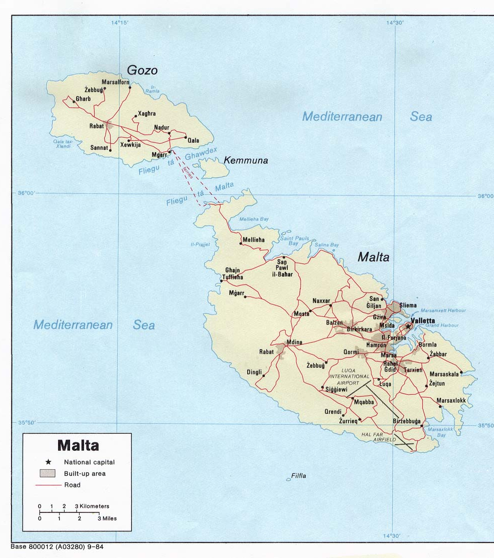
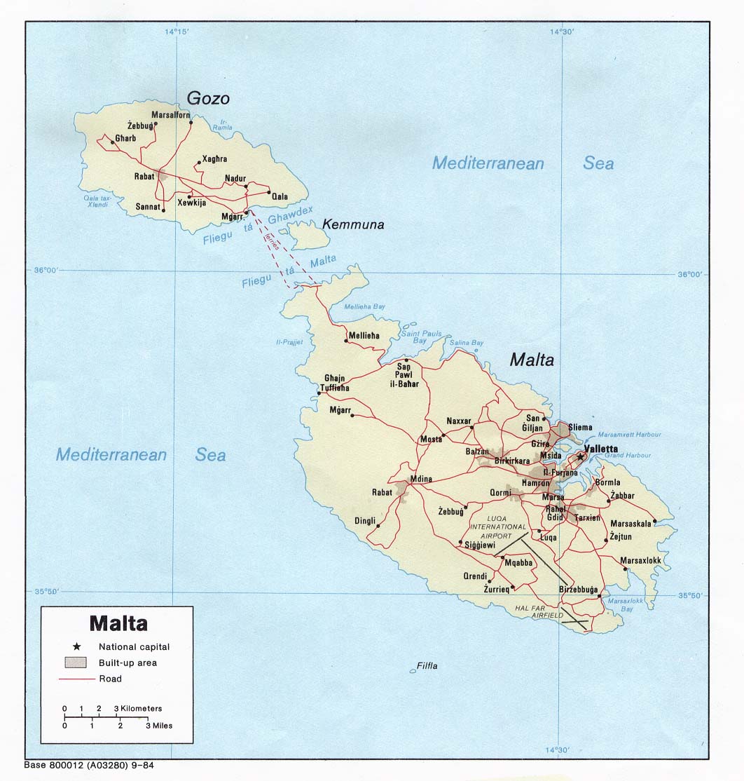
ఈ మునుజూపు పరిమాణం: 531 × 599 పిక్సెళ్ళు. ఇతర రిజల్యూషన్లు: 213 × 240 పిక్సెళ్ళు | 425 × 480 పిక్సెళ్ళు | 987 × 1,114 పిక్సెళ్ళు.
అసలు దస్త్రం (987 × 1,114 పిక్సెళ్ళు, ఫైలు పరిమాణం: 1.34 MB, MIME రకం: image/png)
This is a file from the Wikimedia Commons. Information from its description page there is shown below. Commons is a freely licensed media file repository. You can help. |

|
This map has been uploaded by Electionworld from en.wikipedia.org to enable the |
Political map of Malta. Created in 1984 by the Central Intelligence Agency.
This image is in the public domain because it contains materials that originally came from the United States Central Intelligence Agency's World Factbook.
|
 |
http://www.lib.utexas.edu/maps/europe.html
http://www.lib.utexas.edu/maps/europe/malta_pol84.jpg
ఫైలు చరితం
తేదీ/సమయం ను నొక్కి ఆ సమయాన ఫైలు ఎలా ఉండేదో చూడవచ్చు.
| తేదీ/సమయం | నఖచిత్రం | కొలతలు | వాడుకరి | వ్యాఖ్య | |
|---|---|---|---|---|---|
| ప్రస్తుత | 18:40, 27 డిసెంబరు 2006 | | 987 × 1,114 (1.34 MB) | Electionworld | {{ew|en|Neutrality}} Political map of Malta. Created in 1984 by the Central Intelligence Agency. {{PD-USGov-CIA-WF}} http://www.lib.utexas.edu/maps/europe.html http://www.lib.utexas.edu/maps/europe/malta_pol84.jpg |
లింకులు
కింది పేజీలలో ఈ ఫైలుకు లింకులు ఉన్నాయి:
సార్వత్రిక ఫైలు వాడుక
ఈ దస్త్రాన్ని ఈ క్రింది ఇతర వికీలు ఉపయోగిస్తున్నాయి:
- af.wikipedia.org లో వాడుక
- bs.wikipedia.org లో వాడుక
- ca.wikipedia.org లో వాడుక
- de.wikipedia.org లో వాడుక
- el.wikipedia.org లో వాడుక
- en.wikipedia.org లో వాడుక
- fa.wikipedia.org లో వాడుక
- fr.wikipedia.org లో వాడుక
- hr.wikipedia.org లో వాడుక
- hr.wiktionary.org లో వాడుక
- hu.wikipedia.org లో వాడుక
- io.wikipedia.org లో వాడుక
- ja.wikipedia.org లో వాడుక
- mk.wikipedia.org లో వాడుక
- nn.wikipedia.org లో వాడుక
- pl.wiktionary.org లో వాడుక
- ps.wikipedia.org లో వాడుక
- ro.wikipedia.org లో వాడుక
- sco.wikipedia.org లో వాడుక
- sh.wikipedia.org లో వాడుక
- sl.wikipedia.org లో వాడుక
- sr.wikipedia.org లో వాడుక
- sv.wikivoyage.org లో వాడుక
- trv.wikipedia.org లో వాడుక
- tr.wikipedia.org లో వాడుక
- uk.wikipedia.org లో వాడుక
- zh.wikipedia.org లో వాడుక