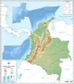
దస్త్రం:Mapa de Colombia (relieve).svg
Jump to navigation
Jump to search

ఈ ఫైలు SVG కు చెందిన ఈ మునుజూపు PNG పరిమాణం: 531 × 599 పిక్సెళ్ళు. ఇతర రిజల్యూషన్లు: 213 × 240 పిక్సెళ్ళు | 425 × 480 పిక్సెళ్ళు | 680 × 768 పిక్సెళ్ళు | 907 × 1,024 పిక్సెళ్ళు | 1,814 × 2,048 పిక్సెళ్ళు | 2,072 × 2,339 పిక్సెళ్ళు.
అసలు దస్త్రం (SVG ఫైలు, నామమాత్రంగా 2,072 × 2,339 పిక్సెళ్ళు, ఫైలు పరిమాణం: 1.79 MB)
ఫైలు చరితం
తేదీ/సమయం ను నొక్కి ఆ సమయాన ఫైలు ఎలా ఉండేదో చూడవచ్చు.
| తేదీ/సమయం | నఖచిత్రం | కొలతలు | వాడుకరి | వ్యాఖ్య | |
|---|---|---|---|---|---|
| ప్రస్తుత | 19:30, 1 ఫిబ్రవరి 2014 |  | 2,072 × 2,339 (1.79 MB) | Milenioscuro | corregido la batimetria |
| 17:57, 1 ఫిబ్రవరి 2014 |  | 2,072 × 2,339 (1.79 MB) | Milenioscuro | archivo correcto | |
| 17:54, 1 ఫిబ్రవరి 2014 |  | 2,072 × 2,339 (1.79 MB) | Milenioscuro | algunas alturas no visibles, arreglado | |
| 16:57, 1 ఫిబ్రవరి 2014 |  | 2,072 × 2,339 (1.79 MB) | Milenioscuro | corregido error en los textos, no visibles antes | |
| 16:31, 1 ఫిబ్రవరి 2014 |  | 2,072 × 2,339 (1.8 MB) | Milenioscuro | colores según las convenciones del taller de cartografía, traducible | |
| 08:41, 25 మే 2012 |  | 2,083 × 2,350 (6.99 MB) | Milenioscuro | pequeño error | |
| 07:04, 25 మే 2012 |  | 2,083 × 2,350 (6.99 MB) | Milenioscuro | mejoras, correcciones y estilo | |
| 23:19, 28 మే 2011 |  | 2,268 × 2,676 (8.29 MB) | Milenioscuro | mejores colores | |
| 07:16, 29 డిసెంబరు 2009 |  | 2,268 × 2,676 (8.33 MB) | Milenioscuro | batimetry | |
| 07:02, 29 డిసెంబరు 2009 |  | 2,268 × 2,676 (8.33 MB) | Milenioscuro | relieve marino |
లింకులు
ఈ ఫైలును వాడుతున్న పేజీలు లేవు.
సార్వత్రిక ఫైలు వాడుక
ఈ దస్త్రాన్ని ఈ క్రింది ఇతర వికీలు ఉపయోగిస్తున్నాయి:
- bg.wikipedia.org లో వాడుక
- cs.wikipedia.org లో వాడుక
- en.wikipedia.org లో వాడుక
- es.wikipedia.org లో వాడుక
- fi.wikipedia.org లో వాడుక
- fr.wikipedia.org లో వాడుక
- hi.wiktionary.org లో వాడుక
- id.wikipedia.org లో వాడుక
- it.wikipedia.org లో వాడుక
- mzn.wikipedia.org లో వాడుక
- nl.wikipedia.org లో వాడుక
- sl.wikipedia.org లో వాడుక
- uk.wikipedia.org లో వాడుక
- www.wikidata.org లో వాడుక


