దస్త్రం:Minnesota Lock and Dam 1 006-062-02-1994.jpg
Jump to navigation
Jump to search
ఈ మునుజూపు పరిమాణం: 605 × 600 పిక్సెళ్ళు. ఇతర రిజల్యూషన్లు: 242 × 240 పిక్సెళ్ళు | 484 × 480 పిక్సెళ్ళు | 929 × 921 పిక్సెళ్ళు.
అసలు దస్త్రం (929 × 921 పిక్సెళ్ళు, ఫైలు పరిమాణం: 246 KB, MIME రకం: image/jpeg)
This is a file from the Wikimedia Commons. Information from its description page there is shown below. Commons is a freely licensed media file repository. You can help. |
సారాంశం
| వివరణ |
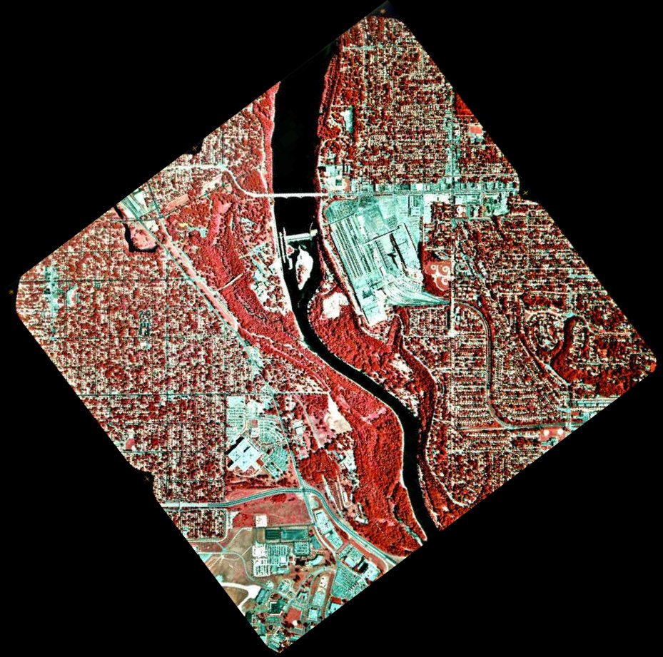
English: 1994 infrared photo of the Mississippi River between Minneapolis and Saint Paul.
Related images
|
| మూలం |
Transferred from en.wikipedia to Commons by Deep silence. (original:ftp://ftp.umesc.er.usgs.gov/pub/gis_data/aerial_photos/1994_upper_mississippi_72dpi/pool_02/006-062-02-1994.jpg) |
| కర్త |
.jpg)

లైసెన్సింగ్
This image is in the public domain in the United States because it only contains materials that originally came from the United States Geological Survey, an agency of the United States Department of the Interior. For more information, see the official USGS copyright policy.
|
అసలు ఎక్కింపుల చిట్టా
The original description page was here. All following user names refer to en.wikipedia.
- 2005-08-20 04:55 SEWilco 929×921× (252387 bytes) 1994 infrared photo of the [[Mississippi River]] between [[Minneapolis, Minnesota|Minneapolis]] and [[Saint Paul, Minnesota|Saint Paul]]. Ford Bridge is just north of Lock and Dam 1, between the Saint Paul Ford Assembly Plant on the right, and Minnehaha
ఫైలు చరితం
తేదీ/సమయం ను నొక్కి ఆ సమయాన ఫైలు ఎలా ఉండేదో చూడవచ్చు.
| తేదీ/సమయం | నఖచిత్రం | కొలతలు | వాడుకరి | వ్యాఖ్య | |
|---|---|---|---|---|---|
| ప్రస్తుత | 13:39, 6 జూలై 2010 | | 929 × 921 (246 KB) | Deep silence | {{Information |Description={{en|1994 infrared photo of the en:Mississippi River between Minneapolis and Saint Paul. * North is up. * Dark red is vegetation while bluish-green is roads, as |
లింకులు
కింది పేజీలలో ఈ ఫైలుకు లింకులు ఉన్నాయి:
సార్వత్రిక ఫైలు వాడుక
ఈ దస్త్రాన్ని ఈ క్రింది ఇతర వికీలు ఉపయోగిస్తున్నాయి:
- en.wikipedia.org లో వాడుక
- fa.wikipedia.org లో వాడుక
- fr.wikipedia.org లో వాడుక
- hy.wikipedia.org లో వాడుక