దస్త్రం:Mr-map.png
Jump to navigation
Jump to search
మరింత స్పష్టమైన బొమ్మ లేదు.
Mr-map.png (326 × 349 పిక్సెళ్ళు, ఫైలు పరిమాణం: 10 KB, MIME రకం: image/png)
This is a file from the Wikimedia Commons. Information from its description page there is shown below. Commons is a freely licensed media file repository. You can help. |

|
This locator map image could be re-created using vector graphics as an SVG file. This has several advantages; see Commons:Media for cleanup for more information. If an SVG form of this image is available, please upload it and afterwards replace this template with
{{vector version available|new image name}}.
It is recommended to name the SVG file “Mr-map.svg”—then the template Vector version available (or Vva) does not need the new image name parameter. |
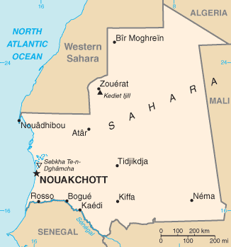
CIA map of Mauritania ([1] archive copy at the Wayback Machine)
This image is in the public domain because it contains materials that originally came from the United States Central Intelligence Agency's World Factbook.
|
 |
derivative works
Derivative works of this file: Mr-map-sv.png
ఫైలు చరితం
తేదీ/సమయం ను నొక్కి ఆ సమయాన ఫైలు ఎలా ఉండేదో చూడవచ్చు.
| తేదీ/సమయం | నఖచిత్రం | కొలతలు | వాడుకరి | వ్యాఖ్య | |
|---|---|---|---|---|---|
| ప్రస్తుత | 18:13, 30 అక్టోబరు 2021 | | 326 × 349 (10 KB) | Lojwe | Cropped 1 % horizontally, 1 % vertically using CropTool with precise mode. |
| 22:55, 9 డిసెంబరు 2007 |  | 328 × 353 (11 KB) | Mahahahaneapneap | pngcrushed | |
| 20:43, 4 మార్చి 2005 |  | 328 × 353 (11 KB) | Alfio | CIA map of Mauritania |
లింకులు
కింది పేజీలలో ఈ ఫైలుకు లింకులు ఉన్నాయి:
సార్వత్రిక ఫైలు వాడుక
ఈ దస్త్రాన్ని ఈ క్రింది ఇతర వికీలు ఉపయోగిస్తున్నాయి:
- als.wikipedia.org లో వాడుక
- ar.wikipedia.org లో వాడుక
- be-tarask.wikipedia.org లో వాడుక
- bs.wikipedia.org లో వాడుక
- cv.wikipedia.org లో వాడుక
- cy.wikipedia.org లో వాడుక
- da.wikipedia.org లో వాడుక
- de.wikinews.org లో వాడుక
- dsb.wikipedia.org లో వాడుక
- en.wikipedia.org లో వాడుక
- en.wikinews.org లో వాడుక
- eo.wikipedia.org లో వాడుక
- es.wikipedia.org లో వాడుక
- fa.wikipedia.org లో వాడుక
- ff.wikipedia.org లో వాడుక
- fi.wikipedia.org లో వాడుక
- fi.wikivoyage.org లో వాడుక
- fr.wikinews.org లో వాడుక
- gd.wikipedia.org లో వాడుక
- gl.wikipedia.org లో వాడుక
- hu.wikipedia.org లో వాడుక
- hu.wiktionary.org లో వాడుక
- ig.wikipedia.org లో వాడుక
- io.wikipedia.org లో వాడుక
- it.wikipedia.org లో వాడుక
- ja.wikipedia.org లో వాడుక
- ka.wikipedia.org లో వాడుక
- lb.wikipedia.org లో వాడుక
- lez.wikipedia.org లో వాడుక
- mdf.wikipedia.org లో వాడుక
- mr.wikipedia.org లో వాడుక
- ms.wikipedia.org లో వాడుక
ఈ దస్త్రపు మరింత సార్వత్రిక వాడుకను చూడండి.