దస్త్రం:Mt Vesuvius 79 AD eruption.svg
Jump to navigation
Jump to search

ఈ ఫైలు SVG కు చెందిన ఈ మునుజూపు PNG పరిమాణం: 800 × 482 పిక్సెళ్ళు. ఇతర రిజల్యూషన్లు: 320 × 193 పిక్సెళ్ళు | 640 × 386 పిక్సెళ్ళు | 1,024 × 617 పిక్సెళ్ళు | 1,280 × 771 పిక్సెళ్ళు | 2,560 × 1,542 పిక్సెళ్ళు.
అసలు దస్త్రం (SVG ఫైలు, నామమాత్రంగా 800 × 482 పిక్సెళ్ళు, ఫైలు పరిమాణం: 87 KB)
This is a file from the Wikimedia Commons. Information from its description page there is shown below. Commons is a freely licensed media file repository. You can help. |
సారాంశం
| వివరణ |
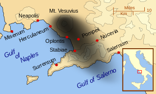
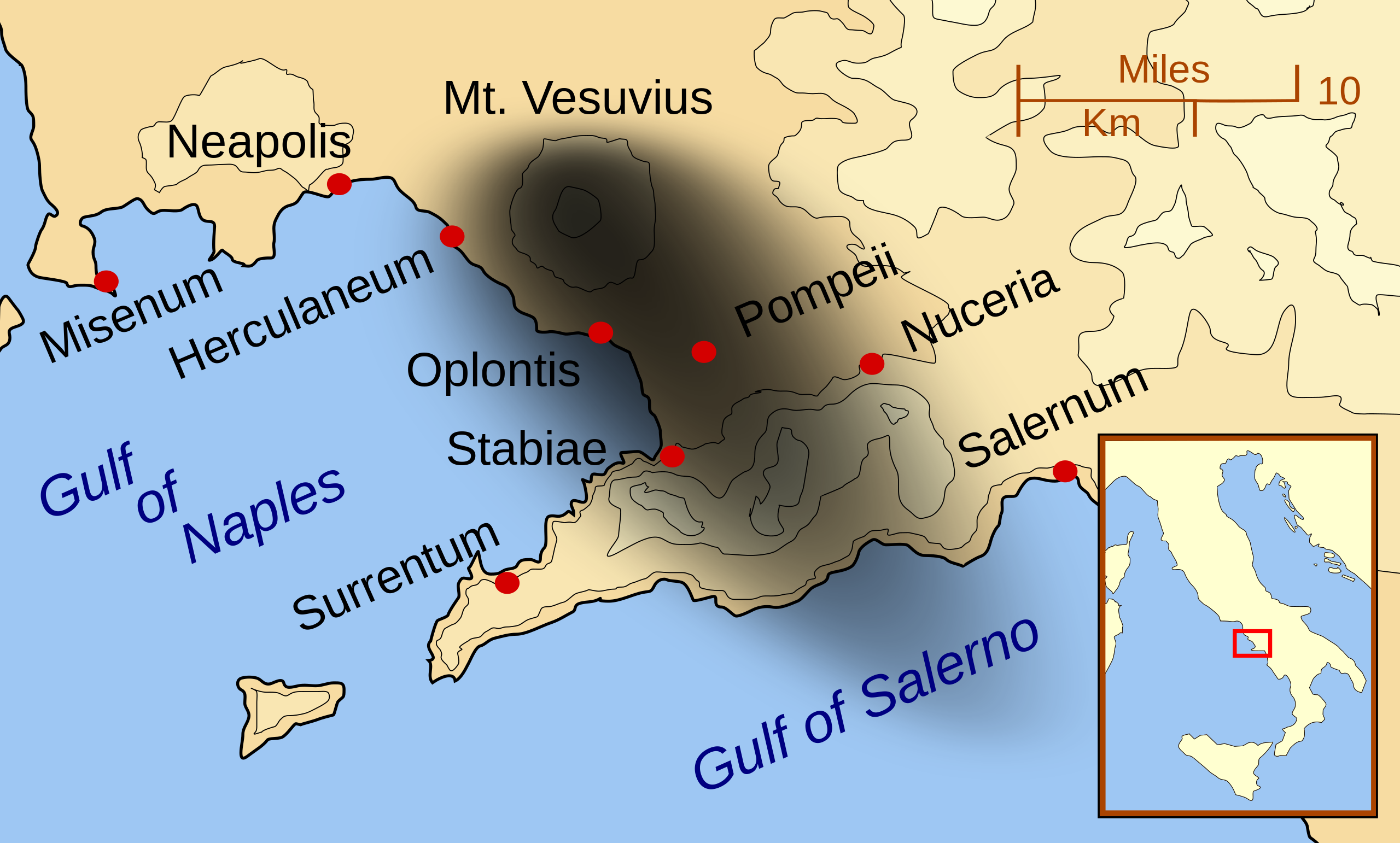
English: A map showing the cities and towns affected by the eruption of Mount Vesuvius in 79 AD. The general shape of the ash and cinder fall (see w:en:pyroclast) is shown by the dark area to the southeast of Mt Vesuvius. (P.S. It seems strange to show the modern day English names for the two bodies of water - I am open to suggestions).
This map shows lines and uses the Mercator projection (although that is not important on a map of this scale). North is, as usual, at the top of the map. |
| తేదీ | |
| మూలం | స్వంత కృతి |
| కర్త | MapMaster |
| ఇతర కూర్పులు |
[]
|


|
This SVG file contains embedded text that can be translated into your language, using any capable SVG editor, text editor or the SVG Translate tool. For more information see: About translating SVG files. |
లైసెన్సింగ్
నేను, ఈ కృతి యొక్క కాపీహక్కుదారుని, దీన్ని ఇందుమూలముగా ఈ లైసెన్సుల క్రింద ప్రచురిస్తున్నాను:

|
ఈ కృతి యొక్క కర్తనైన నేను, ఇక నుండీ ఈ కృతిని కాపీ చేసుకోవడానికి, పంచి పెట్టడానికి మరియు/లేదా మార్పులు-చేర్పులు చేసుకోవడానికి GFDL, లైసెన్సు వెర్షను 1.2 లేదా దాని తరువాత స్వేచ్చా సాఫ్టువేరు ఫౌండేషను విడుదలచేసే ఏ GFDL లైసెన్సు ద్వారా నయినా అనుమతి ఇస్తున్నాను; ఈ కృతిలో మార్చకూడని బాగాలు లేవు, Front-Cover పాఠం లేదు, Back-Cover పాఠం లేదు. ఈ లైసెన్సు యొక్క పత్రం నకలును "జిఎన్యూ ఉచిత డాక్యుమెంటేషను లైసెన్సు" అని పిలుస్తున్న విభాగంలో ఉంది. |
ఈ దస్త్రం క్రియేటివ్ కామన్స్ ఆపాదింపు-యథాతథ పంచుకోలు 3.0 అన్పోర్టెడ్, 2.5 సాధారణం, 2.0 సాధారణం, 1.0 సాధారణం లైసెన్సుల క్రింద లభ్యం.
- ఇలా చేసేందుకు మీకు స్వేచ్ఛ ఉంది:
- పంచుకోడానికి – ఈ కృతిని కాపీ చేసుకోవచ్చు, పంపిణీ చేయవచ్చు, ప్రసారమూ చేయవచ్చు
- రీమిక్స్ చేయడానికి – కృతిని అనుకరించడానికి
- క్రింది షరతులకు లోబడి:
- ఆపాదింపు – సముచితమైన శ్రేయస్సును ఇవ్వాలి, లైసెన్సుకు లింకు ఇవ్వాలి, మార్పులేమైనా చేస్తే వాటిని సూచించాలి. అందుకు సముచితమైన పద్ధతి దేన్నైనా అవలంబించవచ్చు. కానీ మీకూ మీ వాడుకకూ హక్కుదారు అనుమతించారు అనే అర్థం వచ్చేటట్లుగా మాత్రం కాదు.
- share alike – మీరు ఈ కృతిని అనుకరిస్తే, మారిస్తే, లేదా మెరుగుపరిస్తే తత్ఫలిత కృతిని ఇదే లైసెన్సు లేదా దీనికి అనుగుణ్యమైన లైసెన్సు క్రింద మాత్రమే పంపిణీ చేయాలి.
పైవాటిలో మీకు నచ్చిన లైసెన్సునును ఎంచుకోవచ్చు.
| Annotations | This image is annotated: View the annotations at Commons |
ఫైలు చరితం
తేదీ/సమయం ను నొక్కి ఆ సమయాన ఫైలు ఎలా ఉండేదో చూడవచ్చు.
| తేదీ/సమయం | నఖచిత్రం | కొలతలు | వాడుకరి | వ్యాఖ్య | |
|---|---|---|---|---|---|
| ప్రస్తుత | 01:55, 24 ఫిబ్రవరి 2014 | | 800 × 482 (87 KB) | Ras67 | ditto |
| 01:42, 24 ఫిబ్రవరి 2014 |  | 644 × 388 (88 KB) | Ras67 | frame removed | |
| 01:07, 16 అక్టోబరు 2007 |  | 652 × 396 (113 KB) | MapMaster | corrected mis-named Gulf of Salerno | |
| 04:02, 15 అక్టోబరు 2007 |  | 652 × 396 (112 KB) | MapMaster | Dropped Title sqaure, and added towns and names of the 2 bays. | |
| 05:16, 14 అక్టోబరు 2007 |  | 652 × 454 (126 KB) | MapMaster | Minor changes made after seeing how it's rendered by Wikimedia | |
| 05:11, 14 అక్టోబరు 2007 |  | 355 × 247 (125 KB) | MapMaster | {{Information |Description=A map showing the cities and town affected by the eruption of Mount Vesuvius in 79 AD. The general shape of the ash and cinder fall is shown by the dark area to the southeast of Mt Vesuvious. |Source=self-made |Date=October 200 |
లింకులు
కింది పేజీలలో ఈ ఫైలుకు లింకులు ఉన్నాయి:
సార్వత్రిక ఫైలు వాడుక
ఈ దస్త్రాన్ని ఈ క్రింది ఇతర వికీలు ఉపయోగిస్తున్నాయి:
- ar.wikipedia.org లో వాడుక
- bn.wikipedia.org లో వాడుక
- ca.wikipedia.org లో వాడుక
- cs.wikipedia.org లో వాడుక
- da.wikipedia.org లో వాడుక
- de.wikipedia.org లో వాడుక
- el.wikipedia.org లో వాడుక
- en.wikipedia.org లో వాడుక
- eo.wikipedia.org లో వాడుక
- es.wikipedia.org లో వాడుక
- eu.wikipedia.org లో వాడుక
- fa.wikipedia.org లో వాడుక
- fi.wikipedia.org లో వాడుక
- fr.wikipedia.org లో వాడుక
- ga.wikipedia.org లో వాడుక
- gl.wikipedia.org లో వాడుక
- he.wikipedia.org లో వాడుక
- hr.wikipedia.org లో వాడుక
- hu.wikipedia.org లో వాడుక
- hyw.wikipedia.org లో వాడుక
- id.wikipedia.org లో వాడుక
- is.wikipedia.org లో వాడుక
ఈ దస్త్రపు మరింత సార్వత్రిక వాడుకను చూడండి.