దస్త్రం:Niger saharan medieval trade routes.PNG
Jump to navigation
Jump to search
ఈ మునుజూపు పరిమాణం: 800 × 319 పిక్సెళ్ళు. ఇతర రిజల్యూషన్లు: 320 × 128 పిక్సెళ్ళు | 817 × 326 పిక్సెళ్ళు.
అసలు దస్త్రం (817 × 326 పిక్సెళ్ళు, ఫైలు పరిమాణం: 263 KB, MIME రకం: image/png)
This is a file from the Wikimedia Commons. Information from its description page there is shown below. Commons is a freely licensed media file repository. You can help. |
సారాంశం
| వివరణ |
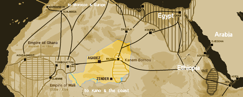
English: Map showing the main trans-Saharan caravan routes circa 1400. Also shown are the Ghana Empire (until the 13th century) and 13th – 15th century Mali Empire. Note the western route running from Djenné via Timbuktu to Sijilmassa. Present day Niger in yellow. Español: Mapa que muestra las principales rutas de caravanas transaharianas alrededor de 1400. También se muestran el Imperio de Ghana (hasta el siglo XIII) y el Imperio de Mali del siglo XIII-XV. Tenga en cuenta la ruta occidental que va desde Djenné a través de Tombuctú a Sijilmassa. En amarillo la extensión del Níger actual. |
| తేదీ | |
| మూలం | self-made using The Gimp and Image:Africa historical traite.JPG |
| కర్త | T L Miles |
| అనుమతి (ఈ దస్త్రాన్ని పునర్వినియోగించుకోవడం) |
Public Domain |

|
This map image could be re-created using vector graphics as an SVG file. This has several advantages; see Commons:Media for cleanup for more information. If an SVG form of this image is available, please upload it and afterwards replace this template with
{{vector version available|new image name}}.
It is recommended to name the SVG file “Niger saharan medieval trade routes.svg”—then the template Vector version available (or Vva) does not need the new image name parameter. |
లైసెన్సింగ్
| నేను, ఈ కృతి యొక్క కాపీహక్కుదారుని, ఈ కృతిని సార్వజనీనం'గా విడుదల చేస్తున్నాను. ఇది ప్రపంచవ్యాప్తంగా వర్తిస్తుంది. కొన్ని దేశాల్లో ఇది చట్టబద్ధంగా సాధ్యంకాకపోవచ్చు; అయితే: ఈ కృతిని ఎటువంటి షరతులు లేకుండా, అట్టి షరతులు చట్టం వల్ల తప్పనిసరి అయితే తప్ప, ఏ ఉద్దేశానికైనా ఉపయోగించుకునే హక్కును ఎవరికైనా నేను ప్రదానం చేస్తున్నాను. |
ఫైలు చరితం
తేదీ/సమయం ను నొక్కి ఆ సమయాన ఫైలు ఎలా ఉండేదో చూడవచ్చు.
| తేదీ/సమయం | నఖచిత్రం | కొలతలు | వాడుకరి | వ్యాఖ్య | |
|---|---|---|---|---|---|
| ప్రస్తుత | 19:09, 18 జనవరి 2008 | 817 × 326 (263 KB) | T L Miles | {{Information |Description=Map of Medieval Saharan Trade routes, centerd on Niger |Source=self-made using The Gimp and Image:Africa historical traite.JPG |Date=2008-01-18 |Author= T L Miles |Permission=Public Domain |other_versions= } |
లింకులు
ఈ ఫైలును వాడుతున్న పేజీలు లేవు.
సార్వత్రిక ఫైలు వాడుక
ఈ దస్త్రాన్ని ఈ క్రింది ఇతర వికీలు ఉపయోగిస్తున్నాయి:
- af.wikipedia.org లో వాడుక
- ar.wikipedia.org లో వాడుక
- arz.wikipedia.org లో వాడుక
- ast.wikipedia.org లో వాడుక
- azb.wikipedia.org లో వాడుక
- az.wikipedia.org లో వాడుక
- ba.wikipedia.org లో వాడుక
- be.wikipedia.org లో వాడుక
- bn.wikipedia.org లో వాడుక
- br.wikipedia.org లో వాడుక
- ca.wikipedia.org లో వాడుక
- cs.wikipedia.org లో వాడుక
- de.wikipedia.org లో వాడుక
- el.wikipedia.org లో వాడుక
- en.wikipedia.org లో వాడుక
- en.wikivoyage.org లో వాడుక
- eo.wikipedia.org లో వాడుక
- es.wikipedia.org లో వాడుక
- eu.wikipedia.org లో వాడుక
- fi.wikipedia.org లో వాడుక
- fr.wikipedia.org లో వాడుక
- ga.wikipedia.org లో వాడుక
- gl.wikipedia.org లో వాడుక
- gu.wikipedia.org లో వాడుక
- ha.wikipedia.org లో వాడుక
- he.wikipedia.org లో వాడుక
- hr.wikipedia.org లో వాడుక
- hu.wikipedia.org లో వాడుక
ఈ దస్త్రపు మరింత సార్వత్రిక వాడుకను చూడండి.