దస్త్రం:Regions and Prefectures of Japan.png
Jump to navigation
Jump to search
ఈ మునుజూపు పరిమాణం: 441 × 600 పిక్సెళ్ళు. ఇతర రిజల్యూషన్లు: 176 × 240 పిక్సెళ్ళు | 353 × 480 పిక్సెళ్ళు | 565 × 768 పిక్సెళ్ళు | 753 × 1,024 పిక్సెళ్ళు | 2,480 × 3,372 పిక్సెళ్ళు.
అసలు దస్త్రం (2,480 × 3,372 పిక్సెళ్ళు, ఫైలు పరిమాణం: 667 KB, MIME రకం: image/png)
This is a file from the Wikimedia Commons. Information from its description page there is shown below. Commons is a freely licensed media file repository. You can help. |

|
File:Regions and Prefectures of Japan.svg is a vector version of this file. It should be used in place of this PNG file when not inferior.
File:Regions and Prefectures of Japan.png → File:Regions and Prefectures of Japan.svg
For more information, see Help:SVG. |
 |
సారాంశం
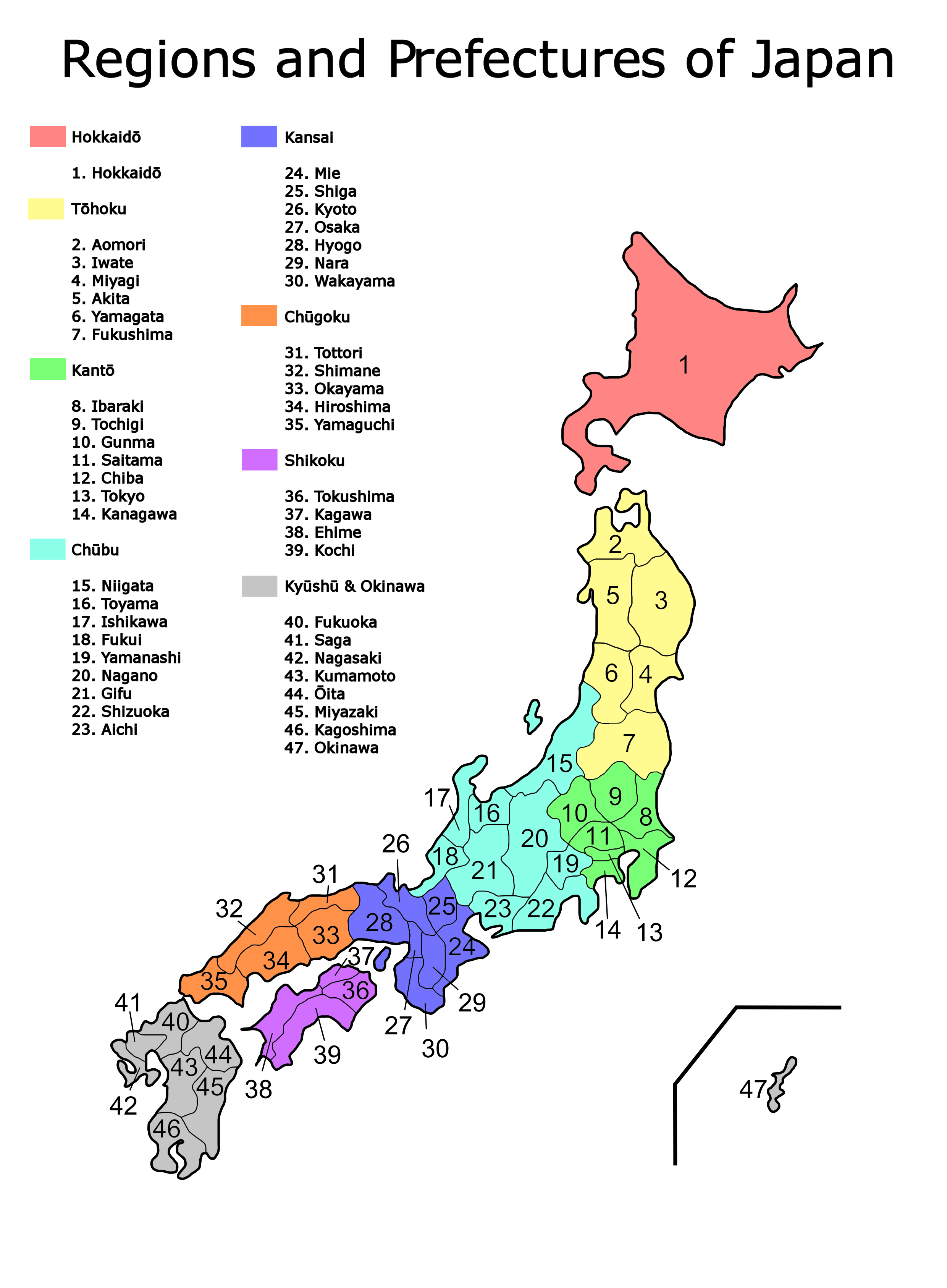
| వివరణ | Map of the regions and prefectures of Japan in ISO 3166-2:JP order. |
| తేదీ | |
| మూలం | Created from Image:Region system8.png |
| కర్త | Bobo12345 |
| ఇతర కూర్పులు |
Derivative works of this file: |
లైసెన్సింగ్
| నేను, ఈ కృతి యొక్క కాపీహక్కుదారుని, ఈ కృతిని సార్వజనీనం'గా విడుదల చేస్తున్నాను. ఇది ప్రపంచవ్యాప్తంగా వర్తిస్తుంది. కొన్ని దేశాల్లో ఇది చట్టబద్ధంగా సాధ్యంకాకపోవచ్చు; అయితే: ఈ కృతిని ఎటువంటి షరతులు లేకుండా, అట్టి షరతులు చట్టం వల్ల తప్పనిసరి అయితే తప్ప, ఏ ఉద్దేశానికైనా ఉపయోగించుకునే హక్కును ఎవరికైనా నేను ప్రదానం చేస్తున్నాను. |
ఫైలు చరితం
తేదీ/సమయం ను నొక్కి ఆ సమయాన ఫైలు ఎలా ఉండేదో చూడవచ్చు.
| తేదీ/సమయం | నఖచిత్రం | కొలతలు | వాడుకరి | వ్యాఖ్య | |
|---|---|---|---|---|---|
| ప్రస్తుత | 05:50, 29 మార్చి 2007 | | 2,480 × 3,372 (667 KB) | Bobo12345~commonswiki | {{Information |Description=Map of the regions and prefectures of Japan in ISO 3166-2:JP order. |Source=Created from Image:Region system8.png |Date=29th March 2007 |Author=User:Bobo12345 |Permission= |other_versions=[[Im |
లింకులు
కింది పేజీలలో ఈ ఫైలుకు లింకులు ఉన్నాయి:
సార్వత్రిక ఫైలు వాడుక
ఈ దస్త్రాన్ని ఈ క్రింది ఇతర వికీలు ఉపయోగిస్తున్నాయి:
- azb.wikipedia.org లో వాడుక
- bat-smg.wikipedia.org లో వాడుక
- bg.wikipedia.org లో వాడుక
- en.wikipedia.org లో వాడుక
- fr.wikibooks.org లో వాడుక
- hu.wikipedia.org లో వాడుక
- incubator.wikimedia.org లో వాడుక
- lt.wikipedia.org లో వాడుక
- pam.wikipedia.org లో వాడుక
- ro.wikipedia.org లో వాడుక
- sa.wikipedia.org లో వాడుక
- sq.wikipedia.org లో వాడుక
- su.wikipedia.org లో వాడుక
- www.wikidata.org లో వాడుక
- zh-min-nan.wikipedia.org లో వాడుక