దస్త్రం:Satellite view of fog over the Golden Gate.jpg
Jump to navigation
Jump to search

ఈ మునుజూపు పరిమాణం: 400 × 600 పిక్సెళ్ళు. ఇతర రిజల్యూషన్లు: 160 × 240 పిక్సెళ్ళు | 320 × 480 పిక్సెళ్ళు | 512 × 768 పిక్సెళ్ళు | 683 × 1,024 పిక్సెళ్ళు | 1,365 × 2,048 పిక్సెళ్ళు | 2,721 × 4,081 పిక్సెళ్ళు.
అసలు దస్త్రం (2,721 × 4,081 పిక్సెళ్ళు, ఫైలు పరిమాణం: 10.21 MB, MIME రకం: image/jpeg)
This is a file from the Wikimedia Commons. Information from its description page there is shown below. Commons is a freely licensed media file repository. You can help. |
సారాంశం
| వివరణ |
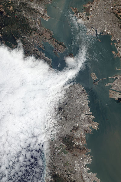
English: The Advanced Land Imager (ALI) on NASA’s Earth Observing-1 (EO-1) satellite acquired this view of fog encroaching on the city on August 16, 2012. The fog is part of the marine layer, a mass of cool, dense air from the sea that was sandwiched beneath a layer of warmer air as part of a temperature inversion. Fog is often present in the lower part of the marine layer, whereas wispy stratus clouds form in the upper part. |
| తేదీ | |
| మూలం | http://earthobservatory.nasa.gov/IOTD/view.php?id=79119 |
| కర్త | NASA Earth Observatory image by Jesse Allen and Robert Simmon, using EO-1 ALI data from the NASA EO-1 team. |
| Camera location | | View this and other nearby images on: OpenStreetMap |
|---|
లైసెన్సింగ్
| This file is in the public domain in the United States because it was solely created by NASA. NASA copyright policy states that "NASA material is not protected by copyright unless noted". (See Template:PD-USGov, NASA copyright policy page or JPL Image Use Policy.) | ||
 |
Warnings:
|
ఫైలు చరితం
తేదీ/సమయం ను నొక్కి ఆ సమయాన ఫైలు ఎలా ఉండేదో చూడవచ్చు.
| తేదీ/సమయం | నఖచిత్రం | కొలతలు | వాడుకరి | వ్యాఖ్య | |
|---|---|---|---|---|---|
| ప్రస్తుత | 18:43, 4 జనవరి 2014 | | 2,721 × 4,081 (10.21 MB) | Minesweeper | User created page with UploadWizard |
లింకులు
కింది పేజీలలో ఈ ఫైలుకు లింకులు ఉన్నాయి:
సార్వత్రిక ఫైలు వాడుక
ఈ దస్త్రాన్ని ఈ క్రింది ఇతర వికీలు ఉపయోగిస్తున్నాయి:
- en.wikipedia.org లో వాడుక
- pt.wikipedia.org లో వాడుక
- www.wikidata.org లో వాడుక