దస్త్రం:Solomon Islands 1989.jpg
Jump to navigation
Jump to search
ఈ మునుజూపు పరిమాణం: 750 × 600 పిక్సెళ్ళు. ఇతర రిజల్యూషన్లు: 300 × 240 పిక్సెళ్ళు | 600 × 480 పిక్సెళ్ళు | 961 × 768 పిక్సెళ్ళు | 1,203 × 962 పిక్సెళ్ళు.
అసలు దస్త్రం (1,203 × 962 పిక్సెళ్ళు, ఫైలు పరిమాణం: 131 KB, MIME రకం: image/jpeg)
This is a file from the Wikimedia Commons. Information from its description page there is shown below. Commons is a freely licensed media file repository. You can help. |
సారాంశం
| వివరణ |
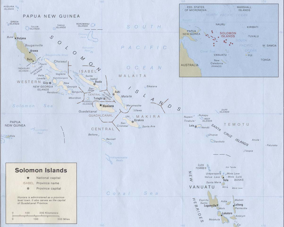
English: Map of the Solomon Islands as of 1989. Province names are included, except for two new provinces as of 1995: the Rennell and Bellona Province (formerly part of Central Province) and the Choiseul Province (formerly part of Western Province). |
| తేదీ | |
| మూలం | Solomon Islands (Political) 1989 from Perry-Castañeda Library Map Collection: Solomon Islands Maps. Cropped to remove white space from edges of map. |
| కర్త | U.S. Central Intelligence Agency |
| అనుమతి (ఈ దస్త్రాన్ని పునర్వినియోగించుకోవడం) |
Public domain |
లైసెన్సింగ్
| This image is a work of a Central Intelligence Agency employee, taken or made as part of that person's official duties. As a Work of the United States Government, this image or media is in the public domain in the United States.
|

|
ఫైలు చరితం
తేదీ/సమయం ను నొక్కి ఆ సమయాన ఫైలు ఎలా ఉండేదో చూడవచ్చు.
| తేదీ/సమయం | నఖచిత్రం | కొలతలు | వాడుకరి | వ్యాఖ్య | |
|---|---|---|---|---|---|
| ప్రస్తుత | 19:27, 25 ఆగస్టు 2009 | | 1,203 × 962 (131 KB) | Zyxw | == {{int:filedesc}} == {{Information | description = {{en|Map of the Solomon Islands as of 1989. Province names are included, except for two new provinces as of 1995: the [[:en:Rennell and B |
లింకులు
ఈ ఫైలును వాడుతున్న పేజీలు లేవు.
సార్వత్రిక ఫైలు వాడుక
ఈ దస్త్రాన్ని ఈ క్రింది ఇతర వికీలు ఉపయోగిస్తున్నాయి:
- af.wikipedia.org లో వాడుక
- ar.wikipedia.org లో వాడుక
- az.wiktionary.org లో వాడుక
- bg.wikipedia.org లో వాడుక
- br.wikipedia.org లో వాడుక
- ca.wikipedia.org లో వాడుక
- cs.wikipedia.org లో వాడుక
- en.wikipedia.org లో వాడుక
- es.wikipedia.org లో వాడుక
- eu.wikipedia.org లో వాడుక
- fr.wikipedia.org లో వాడుక
- gl.wikipedia.org లో వాడుక
- hr.wikipedia.org లో వాడుక
- hu.wikipedia.org లో వాడుక
- hy.wikipedia.org లో వాడుక
- id.wikipedia.org లో వాడుక
- pa.wikipedia.org లో వాడుక
- pl.wikipedia.org లో వాడుక
- pl.wiktionary.org లో వాడుక
- pt.wikipedia.org లో వాడుక
- ro.wikipedia.org లో వాడుక
- ru.wikipedia.org లో వాడుక
- sco.wikipedia.org లో వాడుక
- simple.wikipedia.org లో వాడుక
- su.wikipedia.org లో వాడుక
- tpi.wikipedia.org లో వాడుక
- tr.wikipedia.org లో వాడుక
- uk.wikipedia.org లో వాడుక
ఈ దస్త్రపు మరింత సార్వత్రిక వాడుకను చూడండి.