దస్త్రం:Tibetan empire greatest extent 780s-790s CE.png
Jump to navigation
Jump to search

ఈ మునుజూపు పరిమాణం: 790 × 600 పిక్సెళ్ళు. ఇతర రిజల్యూషన్లు: 316 × 240 పిక్సెళ్ళు | 632 × 480 పిక్సెళ్ళు | 1,011 × 768 పిక్సెళ్ళు | 1,280 × 972 పిక్సెళ్ళు | 1,792 × 1,361 పిక్సెళ్ళు.
అసలు దస్త్రం (1,792 × 1,361 పిక్సెళ్ళు, ఫైలు పరిమాణం: 4.55 MB, MIME రకం: image/png)
This is a file from the Wikimedia Commons. Information from its description page there is shown below. Commons is a freely licensed media file repository. You can help. |
సారాంశం

|
This historical map image could be re-created using vector graphics as an SVG file. This has several advantages; see Commons:Media for cleanup for more information. If an SVG form of this image is available, please upload it and afterwards replace this template with
{{vector version available|new image name}}.
It is recommended to name the SVG file “Tibetan empire greatest extent 780s-790s CE.svg”—then the template Vector version available (or Vva) does not need the new image name parameter. |
| వివరణ |
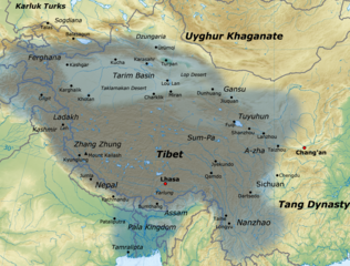
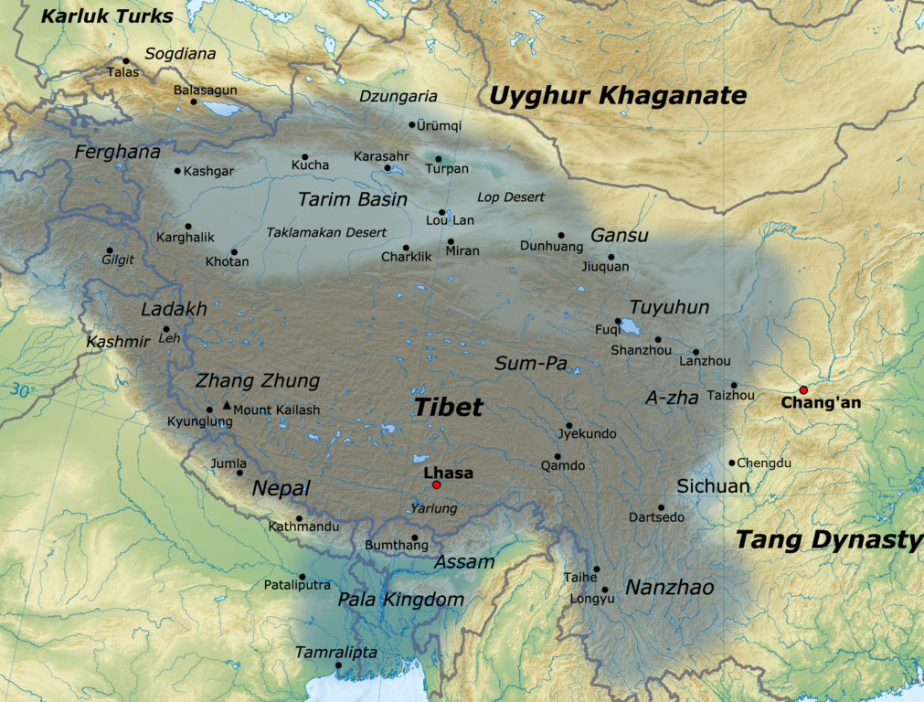
English: Map of the Tibetan Empire at its greatest extent between the 780s and the 790s CE
sources:
|
| తేదీ | |
| మూలం | స్వంత కృతి |
| కర్త | Javierfv1212 |
లైసెన్సింగ్
నేను, ఈ కృతి యొక్క కాపీహక్కుదారుని, దీన్ని ఈ లైసెన్సు క్రింద ఇందుమూలముగా ప్రచురిస్తున్నాను:
ఈ ఫైలు అనుమతి సాధారణ సృజనాత్మకము అపాదింపు ౩.౦ ఆన్-పోర్టెడ్ యందు అనుమతించబడినది.
- ఇలా చేసేందుకు మీకు స్వేచ్ఛ ఉంది:
- పంచుకోడానికి – ఈ కృతిని కాపీ చేసుకోవచ్చు, పంపిణీ చేయవచ్చు, ప్రసారమూ చేయవచ్చు
- రీమిక్స్ చేయడానికి – కృతిని అనుకరించడానికి
- క్రింది షరతులకు లోబడి:
- ఆపాదింపు – సముచితమైన శ్రేయస్సును ఇవ్వాలి, లైసెన్సుకు లింకు ఇవ్వాలి, మార్పులేమైనా చేస్తే వాటిని సూచించాలి. అందుకు సముచితమైన పద్ధతి దేన్నైనా అవలంబించవచ్చు. కానీ మీకూ మీ వాడుకకూ హక్కుదారు అనుమతించారు అనే అర్థం వచ్చేటట్లుగా మాత్రం కాదు.
ఫైలు చరితం
తేదీ/సమయం ను నొక్కి ఆ సమయాన ఫైలు ఎలా ఉండేదో చూడవచ్చు.
| తేదీ/సమయం | నఖచిత్రం | కొలతలు | వాడుకరి | వ్యాఖ్య | |
|---|---|---|---|---|---|
| ప్రస్తుత | 16:11, 16 జనవరి 2021 | | 1,792 × 1,361 (4.55 MB) | Liandrei | Cropped black border |
| 16:00, 29 మార్చి 2011 |  | 1,800 × 1,361 (4.56 MB) | Javierfv1212 | {{Information |Description ={{en|1=Map of the Tibetan empire at it's Greatest extent between the 780s and the 790s CE sources: http://academic.reed.edu/anthro/364/maps.html http://unitednations4freetibet.com/unfft/wp-content/uploads/2010/11/The-Nation |
లింకులు
కింది పేజీలలో ఈ ఫైలుకు లింకులు ఉన్నాయి:
సార్వత్రిక ఫైలు వాడుక
ఈ దస్త్రాన్ని ఈ క్రింది ఇతర వికీలు ఉపయోగిస్తున్నాయి:
- af.wikipedia.org లో వాడుక
- ar.wikipedia.org లో వాడుక
- azb.wikipedia.org లో వాడుక
- az.wikipedia.org లో వాడుక
- ba.wikipedia.org లో వాడుక
- bg.wikipedia.org లో వాడుక
- bn.wikipedia.org లో వాడుక
- bo.wikipedia.org లో వాడుక
- bs.wikipedia.org లో వాడుక
- ca.wikipedia.org లో వాడుక
- cs.wikipedia.org లో వాడుక
- da.wikipedia.org లో వాడుక
- de.wikipedia.org లో వాడుక
- en.wikipedia.org లో వాడుక
- es.wikipedia.org లో వాడుక
- eu.wikipedia.org లో వాడుక
- fa.wikipedia.org లో వాడుక
- fi.wikipedia.org లో వాడుక
- fr.wikipedia.org లో వాడుక
ఈ దస్త్రపు మరింత సార్వత్రిక వాడుకను చూడండి.