దస్త్రం:Toronto map.png
Jump to navigation
Jump to search

ఈ మునుజూపు పరిమాణం: 800 × 595 పిక్సెళ్ళు. ఇతర రిజల్యూషన్లు: 320 × 238 పిక్సెళ్ళు | 640 × 476 పిక్సెళ్ళు | 1,024 × 761 పిక్సెళ్ళు | 1,280 × 951 పిక్సెళ్ళు | 1,500 × 1,115 పిక్సెళ్ళు.
అసలు దస్త్రం (1,500 × 1,115 పిక్సెళ్ళు, ఫైలు పరిమాణం: 703 KB, MIME రకం: image/png)
This is a file from the Wikimedia Commons. Information from its description page there is shown below. Commons is a freely licensed media file repository. You can help. |
|
| వివరణ |
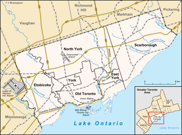
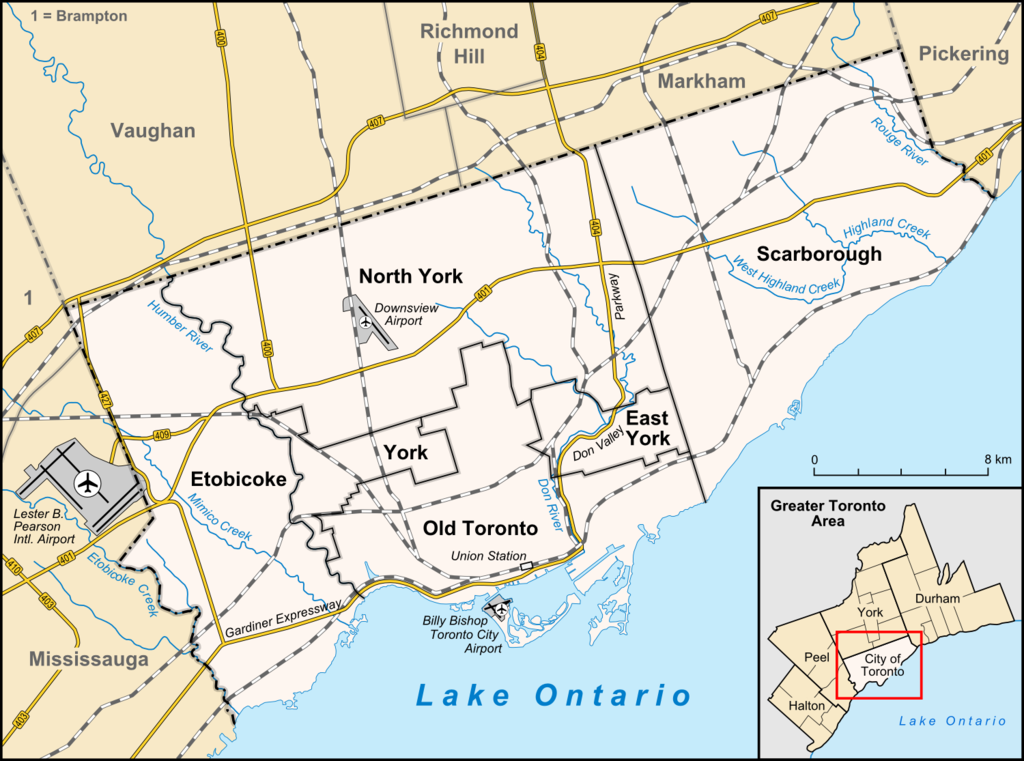
English: Map of Toronto
Français : Carte de Toronto
Deutsch: Karte von Toronto
Bahasa Indonesia: Peta kota Toronto |
| తేదీ | |
| మూలం |
own work, used:
|
| కర్త | Lencer |

|
This map has been made or improved in the German Kartenwerkstatt (Map Lab). You can propose maps to improve as well.
|
ఈ దస్త్రం క్రియేటివ్ కామన్స్ Attribution-Share Alike 3.0 Unported లైసెన్సు క్రింద లభ్యం.
- ఇలా చేసేందుకు మీకు స్వేచ్ఛ ఉంది:
- పంచుకోడానికి – ఈ కృతిని కాపీ చేసుకోవచ్చు, పంపిణీ చేయవచ్చు, ప్రసారమూ చేయవచ్చు
- రీమిక్స్ చేయడానికి – కృతిని అనుకరించడానికి
- క్రింది షరతులకు లోబడి:
- ఆపాదింపు – సముచితమైన శ్రేయస్సును ఇవ్వాలి, లైసెన్సుకు లింకు ఇవ్వాలి, మార్పులేమైనా చేస్తే వాటిని సూచించాలి. అందుకు సముచితమైన పద్ధతి దేన్నైనా అవలంబించవచ్చు. కానీ మీకూ మీ వాడుకకూ హక్కుదారు అనుమతించారు అనే అర్థం వచ్చేటట్లుగా మాత్రం కాదు.
- share alike – మీరు ఈ కృతిని అనుకరిస్తే, మారిస్తే, లేదా మెరుగుపరిస్తే తత్ఫలిత కృతిని ఇదే లైసెన్సు లేదా దీనికి అనుగుణ్యమైన లైసెన్సు క్రింద మాత్రమే పంపిణీ చేయాలి.
ఫైలు చరితం
తేదీ/సమయం ను నొక్కి ఆ సమయాన ఫైలు ఎలా ఉండేదో చూడవచ్చు.
| తేదీ/సమయం | నఖచిత్రం | కొలతలు | వాడుకరి | వ్యాఖ్య | |
|---|---|---|---|---|---|
| ప్రస్తుత | 14:33, 3 ఏప్రిల్ 2012 | | 1,500 × 1,115 (703 KB) | Lencer | + don river, minor adds of river names |
| 15:59, 29 జూన్ 2009 |  | 1,500 × 1,115 (585 KB) | SimonP | correct minor error | |
| 15:18, 29 జూన్ 2009 |  | 1,500 × 1,115 (585 KB) | SimonP | Corect East York border | |
| 10:56, 18 జూన్ 2009 |  | 1,500 × 1,115 (677 KB) | Lencer | + don valley parkway | |
| 18:56, 25 మార్చి 2009 |  | 1,500 × 1,115 (673 KB) | Lencer | Int. => Intl. | |
| 12:19, 18 మార్చి 2009 |  | 1,500 × 1,115 (672 KB) | Lencer | Vaugahn -> Vaughan | |
| 06:54, 10 మార్చి 2009 |  | 1,500 × 1,115 (673 KB) | Lencer | fix Greater Toronto Area | |
| 12:29, 9 మార్చి 2009 |  | 1,500 × 1,115 (672 KB) | Lencer | + Minimap, some fixes | |
| 19:10, 8 మార్చి 2009 |  | 1,500 × 1,116 (628 KB) | Lencer | weitere Kartenelemente erg., Farben geändert | |
| 20:02, 2 మార్చి 2009 |  | 1,500 × 1,116 (475 KB) | Lencer | Fehlerhafte Grenze bei York |
లింకులు
కింది పేజీలలో ఈ ఫైలుకు లింకులు ఉన్నాయి:
సార్వత్రిక ఫైలు వాడుక
ఈ దస్త్రాన్ని ఈ క్రింది ఇతర వికీలు ఉపయోగిస్తున్నాయి:
- ar.wikipedia.org లో వాడుక
- ban.wikipedia.org లో వాడుక
- ceb.wikipedia.org లో వాడుక
- ckb.wikipedia.org లో వాడుక
- de.wikipedia.org లో వాడుక
- Toronto
- Benutzer:Lencer
- Wikipedia:Exzellente Bilder/Karten und Satellitenbilder
- Liste der Ortsteile von Toronto
- Wikipedia:Kartenwerkstatt/Archiv/2009-03
- Wikipedia:Kandidaten für exzellente Bilder/Archiv2009/6
- Datei:Toronto map.png
- Toronto Fire Services
- Taber Hill
- Wikipedia:Kartenwerkstatt/Schaufenster
- Wikipedia:Exzellente Bilder/Kleine Bilder
- en.wikipedia.org లో వాడుక
- Toronto
- Rogers Centre
- Yonge–Dundas Square
- Billy Bishop Toronto City Airport
- Don River (Ontario)
- Forest Hill, Toronto
- Humber River (Ontario)
- The Annex
- Royal Ontario Museum
- Cabbagetown, Toronto
- Rosedale, Toronto
- The Beaches, Toronto
- High Park
- The Kingsway, Toronto
- Baby Point
- Bendale
- The Junction
- Little Italy, Toronto
- New Toronto
- Leslieville
- Kensington Market
- Scotiabank Arena
- Riverdale, Toronto
- Metropolitan Toronto
- Union Station (Toronto)
- Swansea, Toronto
- Parkdale, Toronto
- Rouge River (Ontario)
- Ontario Science Centre
- Black Creek Pioneer Village
- Agincourt, Toronto
ఈ దస్త్రపు మరింత సార్వత్రిక వాడుకను చూడండి.